
Page 156 - (DK Eyewitness) Travel Guide - India
P. 156
154 DELHI & THE NOR TH
w Rangdum the grandeur of its
landscapes, the
Kargil district. 110 km (68 miles) SE of
Kargil. @ n Kargil Tourist Office, simplicity of life in
(01985) 232 721. its villages, and the
serene ambience in its
The village of Rangdum serves gompas, often built
as a night halt between Kargil around ancient cliff
(see p151) and Zanskar. Though top meditation caves.
geographically part of the Suru Zanskar contains
Valley, its largely Buddhist popu the valleys of two
lation and its monastery orient rivers, the Stod and
it culturally towards Zanskar. the Lungnak which,
Situated on a wide flat plateau at flowing towards
3,800 m (12,467 ft), criss crossed each other along
by water courses, and framed by the northern flank of
snow peaks and hills of curiously the Greater Himalayas,
striated rock, Rangdum has a wild, join to become the
desolate beauty. The fortresslike Zanskar river. This
18thcentury Gelugpa Monastery continues north
is built on a hillock, and a small through a gorge in
temple in the complex has a the Zanskar Range,
fine wall painting of a battle to join the Indus.
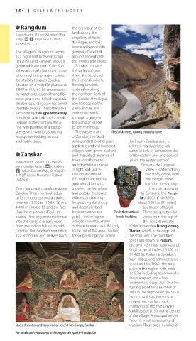
scene, with warriors sporting The western arm The Zanskar river, running through a gorge
Mongolianlooking armour of Zanskar, the Stod
and battle dress. Valley, and its central plain the frozen Zanskar river, to
are fertile and well watered – sell their highly prized yak
villages form green pockets, butter in Leh. In contrast to the
e Zanskar and the virtual absence of fertile western arm and central
Kargil district. 230 km (143 miles) SE trees contributes to plain, the eastern arm of
from Kargil to Padum. @ to Padum. an extraordinary sense Zanskar – the Lungnak
n Padum Tourist Office, (01983) 254 of light and space. Valley – is a forbidding
017. _ Karsha Monastery Festival The inhabitants of and stony gorge, with
(Jul/Aug). this region are mostly few villages to be
agricultural farmers, found in the vicinity.
There is a certain mystique about growing barley, wheat The main gateway
Zanskar. This is no doubt due and peas in the lower to Zanskar is the Pensi-
to its remoteness and altitude, villages, and raising la (4,400 m/14,436 ft),
between 3,350 m (10,991 ft) and livestock – yaks, sheep about 130 km (81 miles)
4,400 m (14,436 ft), and the fact and dzos (a hybrid southeast of Kargil.
that the region is difficult to between cows and Perak, the traditional There are spectacular
access – the only motorable road yaks) – in the higher female headdress views from the top of
into the valley is usually open villages. In winter, many this pass, especially
from around early June to mid of these farmers take the only of the impressive Drang-drung
October. But Zanskar’s reputation route out of the area, trekking Glacier, which is the origin of
as a Shangrila also derives from for six gruelling days across the Stod river. The road then
continues down to Padum,
230 km (143 miles) southeast of
Kargil, at an altitude of 3,500 m
(11,483 ft). Padum is Zanskar’s
main village and administrative
headquarters. This is the only
place in the region with basic
facilities including accom moda
tion, transport and a few
rudimentary shops. It is also the
starting point for a number of
treks in the region (see pp156–7).
Padum itself has few sites of
interest, except for a rock
engraving of the Five Dhyani
Buddhas (see p150) in the centre
of the village. A mosque serves
Padum’s small community of
Stucco decoration and images in bas-relief at Sani Gompa, Zanskar Muslims. There are a number of
For hotels and restaurants in this region see pp695–6 and p708
154-155_EW_India.indd 154 26/04/17 11:43 am
Eyewitness Travel LAYERS PRINTED:
Catalogue template “UK” LAYER
(Source v2.6)
Date 12th July 2013
Size 125mm x 217mm