
Page 462 - NEWGEN21-Proceedings-Full
P. 462
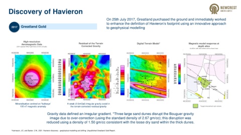
Discovery of Havieron


                                                                                      On 25th July 2017, Greatland purchased the ground and immediately worked
                                                                                      to enhance the definition of Havieron’s footprint using an innovative approach
          2017    Greatland Gold                                                      to geophysical modelling


                    High-resolution
                  Aeromagnetic Data                             Residual of the Terrain                       Digital Terrain Model*                   Magnetic model response at
              (50m spaced NNE flight lines at 40m altitude)       Corrected Gravity                                                                            depth slice
                                                                                                                                                        d=420m with drill collars and surface trace


             Mineralisation centred on “bullseye’      A weak (0.5mGal) irregular gravity ovoid in
                 100 nT magnetic anomaly                 the terrain corrected residual gravity                                                                  Target mineralized rock volume

                                       Gravity data defined an irregular gradient. *Three large sand dunes disrupt the Bouguer gravity
                                         image due to over-correction (using the standard density of 2.67 gm/cc); this disruption was
                                      reduced using a density of 1.50 gm/cc consistent with the loose dry sand within the thick dunes.


          1 Hanneson, J.E. and Baxter, C.N., 2021. Havieron discovery - geophysical modelling and drilling. Unpublished Greatland Gold Report.