
Page 52 - Computing Book 7
P. 52
All About Cloud Class 7
Google Translate Text from Photos:
You can translate text in photos you’ve already taken. You can also take a new photo in the Translate
app and translate text on the new photo.
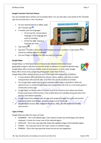
• On your Android phone or tablet, open
the Translate app
• If needed, pick the languages.
o At the top left, choose Detect
language or the language you
want to translate.
o At the top right, choose a
language you read.
• Tap Camera .
• Tap Scan to take a new photo and translate any text it contains, or tap Import to
choose an existing photo to translate.
• Use your finger to highlight the text you want to translate.
Google Maps:
Google Maps is a Web-based service that provides detailed information about
geographical regions and sites around the world. In addition to conventional road maps,
Google Maps offers aerial and satellite views of many places. In some cities, Google
Maps offers street views comprising photographs taken from vehicles.
Google Maps offers several services as part of the larger Web application, as follows.
• A route planner offers directions for drivers, bikers, walkers, and users of public
transportation who want to take a trip from one specific location to another.
• The Google Maps application program interface (API) makes it possible for Web site
administrators to embed Google Maps into a proprietary site such as a real estate guide or
community service page.
• Google Maps for Mobile offers a location service for motorists that utilizes the Global
Positioning System (GPS) location of the mobile device (if available) along with data from
wireless and cellular networks.
• Google Street View enables users to view and navigate through horizontal and vertical
panoramic street-level images of various cities around the world.
• Supplemental services offer images of the moon, Mars, and the heavens for hobby
astronomers.
Types of Maps
Google Maps provides four types of maps:
• ROADMAP − This is the default type. If you haven't chosen any of the types, this will be
displayed. It shows the street view of the selected region.
• SATELLITE − This is the map type that shows the satellite images of the selected region.
• HYBRID − This map type shows the major streets on satellite images.
• TERRAIN − This is the map type that shows the terrain and vegetation.
The City School/Academics/Computing Curriculum/Class7/2020-2021 Page 51 of 95