
Page 187 - NAVAL SCIENCE 3 TEXTBOOK
P. 187
l\IARINE NAV I GATION 193
Meridians The starting point for numbering the parallels is the equator.
the 0° parallel. Parallels are numbered from 0° at the equator to 90°
There are an infinite number of meridians running from pole to
north (N) at the north pole, and from 0' to 90' south (5) at the
pole, but rarely are they drawn more often than one for each degree
south pole. A place in the Northern Hemisphere. for example, might
around the Earth. On the average globe. map or chart, meridians
be located at 35°N, while one in the Southern Hemisphere might be
are usually drawn every 5 or 10 degrees. ~'lore will sometimes 0
at 50 S. In navigation. the parallels are called latitl/de lines.
be drawn all enlarged navigation charts. The starting point for
numbering these meridians is the meridian on which the Royal
Observatory at Greenwich, England, is located. The Greenwich Latitude and Longitude
meridian, therefore, is numbered 0, or 0°, and is called the prime
\'Ve have seen that there is a network of meridians and parallels
11lcridialJ.
all the wa), around the globe. Thus, ever), spot on Earth ma)' be
located at the intersection of a meridian and a parallel. The navi-
gator describes every location on the Earth in terms of its corre-
sponding latitude and longitude. Latitude is the distance of arc
north (N) or south (5) of the equator. It is expressed in degrees,
minutes, and seconds, measured along the meridian of the place.
longitude is the distance in degrees. minutes, and seconds of arc
east (E) or west (\V) of the prime meridian. measured along the
parallel of latitude. Let's state it again: latitude is always measured
north or south from 0° through 90°, and longitude is always mea-
sured east or west from 0° through 180°.
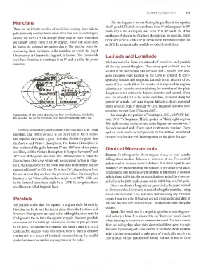
A projection of the globe showing the four hemispheres, divided by For example, the position of Washington, D.C., is 38'58'N lati-
the equator, the prime meridian, and the International Date Line. tude, 7rOJ'\V longitude. This is spoken as "thirty-eight degrees,
fifty-eight minutes north; seventy-seven degrees, one minute west."
Seconds are used only if very exact locations are required. Eveq'
Halfway around the globe from the prime meridian is the 180th
spot on Earth can be located precisel), b)' this method. You should
meridian. The 180th meridian is the other half of the 0 merid-
become vcr}' familiar with locating places on the globe this way.
ian; together they make a great circle that divides the globe into
the Emtem and ''''estem Hemispheres. The Eastern Hemisphere is
that portion of the globe between 0° and 180° east of the prime
Nautical Measurements
meridian, and the \-"estern Hemisphere is that part between 0° and
Distance. In talking earlier about degrees of arc, we were actually
180° west of the prime meridian. The 180th meridian is called the
talking about nautical distance, or distances at sea. The nautical
illte/'IJatio/wl Date LillC, which will be discussed further in chap-
mile is used to measure nautical distance. It is about equal to one
ter 4. Meridians between the prime meridian and the date line are
minute of arc measured along the equator, or any other great circle.
numbered from 0° to 180° east (E) or west (\V ). depending on how
That is about one and one-seventh statute or land miles. A nautical
far east or west they are from the prime meridian. For example, a
mile is about 6.076 feet; for most applications in the Navy, we con-
location in the \Vestern Hemisphere might be at 700\V, while one
sider this to be 2,000 ),ards. A land mile is 5,280 feet, or 1,760 yards.
in the Eastern Hemisphere might be at 1200E. In navigation these
Since meridians oflongitude are great circles, they may be used
meridians are called IOl/gitl/de lines.
as distance scales. Distance is measured along the meridian, using
a tool called dividers. One minute of latitude along an)' meridian
Parallels equals 1 nautical mile. (Distances are not measured on parallels of
latitude, because one minute equals 1 nautical mile only along the
\'Vc learned earlier that the equator is a great circle formed b)'
equator.)
bisecting the Earth on a horizontal plane. Since the Northern and
Speed. The word kllot is a seagoing speed term meaning nau-
Southern Hemispheres are equal hi.llves of the globe, there must be
tical miles per hour. It is incorrect to say "knots per hour," except
90 degrees in the arc from the equator to a pole. However, parallels
when referring to increases or decreases in speed. The term comes
drawn around the Earth get smaller and smaUer as you get closer
from old sailing days. when ships deterrnined their speed through
to the poles. 13lH remember, no matter how small a circle it is, it still
the water by funning out a line knotted at fractions of one nautical
contains 360 degrees. \Vhat this means, then, is that the distance
mile. The line was attached to a flat piece of wood called a chip log.
represented by a degree of longitude measured along the parallel
The amount of line (numbers of knots) run out in two or three
circles becomes ever smaller as you get nearer the poles.