
Page 189 - NAVAL SCIENCE 3 TEXTBOOK
P. 189
~!AR! N E NAV !GAT!O N 195
TRUE NORTH To go from a relative to a true bearing, just add the ship's true
course to the relative bearing of the object sighted. If the sum is
less than 360°, that sum is the true bearing of the object. If the sum
is more than 360°, subtract 360° from the sum, and that difference
will be the true bearing of the object.
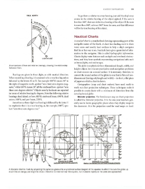
Nautical Charts
A /l(lIIticnl chart is a standardized drawing representing part of the
navigable waters of the Earth. A chart has shading on it to show
water areas and nearby land outlines to help a ship's navigator
find his or her wa}' at sea. Nautical charts give a great deal of infor-
mation to the navigator. This is called hyrlrographic ill/ormation.
'0 Charts display water features such as depth and overhead obstruc-
LIGHTHOUSE
tions, and they have symbols representing navigational aids such
as buoys, lights, and anchorages.
A comparison of true and relative bearings, showing the relationship The globe is a spherical, three-dimCI1sional (length, width, and
between them.
height) object, but it is not practical to work navigation problems
or chart courses on a round surface. It is necessaq', therefore, to
Bearings are given in three digits, as with nautical direction. convert the round surface of the globe to one that is flat and two-
\"'hen recording a bearing, it is assumed to be a true bearing unless dimensional (having only length and width) - in short, a flat piece
followed by the letters lvl or R. For example 030°1\,1 means 30° to of paper on which a chart is drawn.
the right of magnetic north, spoken "zero three zero degrees mag- Cartographers (map and chart makers) have used math to
0
netic:' while 030 R means 30° off the starboard bow. spoken "zero work out chart projection techniques. These techniques make it
three zero degrees relative," Objects seen by lookouts arc reported possible to create charts with a minimum of distortion from the
in terms of relative bearing by degrees. Note the following relative actual spherical globe.
o
bearings: dead ahead, or bow, OOooR; starboard beam, 090 R; dead Mercator projection. The best-known map or chart projection
o
astern, 180 R; and port beam, 2700R. is called the klermtor projectioll. It is the one your teachers gen-
Sometimes a three-digit true bearing is followed by the letter T erally use to locate geographic places when they display maps in
to emphasize that it is a true bearing, as, for example, 030<>'[, spo- the classroom. It is the projection used for road maps on land.
ken "zero three zero degrees true."
.---.---.-~~~~--~~--,.~
'\)0 ~;r (;
J.~J.:.
C ~..;~~. \S.~~:~ff
ftA:i.&~~'ro {l)~ ",
THE GLOBE UNfOlO£O
60' ~~ "\ii~~~jrl>~
H P.
I h 1Yi '.',:'.,.:;D.' ~ ~~ \I,} , "\ '''''f
v/ rj) '"'l. )T\1 \'\ 30° ~:~ K6:.t .'::'
:"i3:t::
'~
II V'\1;K~ ~~~ I ~h
IBOO
1+-4--JI)' .",,,
" 1\ fj~~ H'········ 4501'· .... ~ ~@, :~
Wi.;:r-"-i<'---'''---iL-:r-,,,-Ji, '-I--.,'L+~:==l""-t-=;fia'l-~'-1'" .§:~ f.--+---+----t--#...jll"bW=-+---~ lO"
fIl V
~i~
~'
I~l\
...
}I
\l,' y--_.1 ~ __ -1 \~ ·-h.z:'E; !II'
i~
V SQ M 9q' ,-...... 60t ... , ·'-;l'W"'--',"'"20",--;!;,,--.l60,,-lO lii"" 60° ....L 1600 I~O. 120· 90. bO° 30· o~
S. P.
UNR.OLLED AS A CH"'RT •.
" WIlt.," HCmispMl'!j (,om 60°5 lo80"tl MtrcatOl"lTojtdicrl
q,.
A Mercator chart is made by projecting the spherical globe onto a cylindrical surface tangent at the equator. In effect this cuts the globe up
much like an orange peel might be sliced. Distortion is minimal near the equator, but increases rapidly as the poles are approached.