
Page 188 - NAVAL SCIENCE 3 TEXTBOOK
P. 188
194 NAVAL SKILLS
minutes gave an estimate of the ship's speed, from which the num-
ber of nautical miles covered per hour could be figured.
Nowadays ship speed through the water is determined by use
of a speed log (like a speedometer), either mechanical or electronic.
Mechanical speed logs have a small propeller that extends down
beneath a vessel's hulL The water streaming past the hull rotates
the propeller, and the vessel's speed is proportional to the speed
of rotation. Others have a pitot Wbe that measures the speed of the
water stream by pressure difterences. Electronic speed logs mea-
sure vessel speed electronically by projecting sound beams down
into the ,vater.
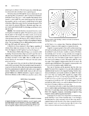
Direction. True llautical direction is measured from true north
(north pole) as located on a globe. This used to be given in olden
days by poillts on the compass rose, such as north, north by east,
north-northeast, and so on.lvlodern navigators use a system of cir-
cular measurement using 360 degrees of are, which is more accu-
Relative bearing card showing numerical and descriptive relative
rate and convenient. A compass card shO\vs the readings of degrees bearings from a ship.
of arc. The true bearings of the so-called cardinal points are north,
000'; east, 090'; south, 180'; and west, 270'. or Girl Scout or in a science class. Directions referenced to the
A direction is always expressed in three figures, regardless of magnetic compass are called magnetic or compass directions.
whether three digits are necessary. In other words, it is not 45° Magnetic compasses point to the Earth's northernmost mag-
(forty-five degrees), but 045' (spoken "zero four five degrees"). netic pole, presently positioned at about 80 degrees north latitude
The direction in which a ship is facing at any moment is called in northern Canada. Its location wanders as nmch as 80 kilome-
its heading. The direction that a ship is steered through the water is ters each day, and it has been moving northerly at an average rate
called its course. Because they are directions, headings and courses of about 10 kilometers per year. Because it is at a distance from the
are always expressed in three digits. There is usually some dif- true north pole, there is usually an angle between magnetic and
ference between the two because of wind and wave and current true north at all locations on Earth. This angle is called the varia-
action and the like, tion (mgle, If the magnetic compass points east of true north, the
ivIost larger naval ships and aircraft are fitted with an instru- variation angle is labeled east. If the magnetic compass points west
ment caned a gyrocompass that always points toward true north. It of true north, the variation angle is labeled west.
is used as the basis for all true direction and course measurements. One type of direction can be converted into the other very
However, a gyrocompass is expensive and needs a power supply to simply. To convert from magnetic to true, just add or subtract the
operate. Therefore, most smaller vessels, boats, aircraft, and many variation at your location to the magnetic bearing. 'Vesterly varia-
ground vehicles use a relatively inexpensive magnetic compass as a tions are subtracted, and easterly variations are added. For exam-
directional reference, similar to those you may have used as a Boy ple, if your ship were heading 090° magnetic in a region where
the variation was 10° east, the true heading would be 090° + 10°,
or 100° true. If you wanted to proceed on course 270° true in the
NORTH POLE (TRUE NORTH)
same region, you would steer 270° - 10° or 260° magnetic. The size
and direction of the variation can easily be obtained from the nau-
tical chart of the area in which you are operating.
It is important to be able to make these kinds of conversions
because nautical charts and land maps are drawn up based on true
directions, but small ships, boats, and land vehicles are most often
fitted with magnetic compasses, necessitating navigation using
magnetic courses and bearings described below.
A bearing is the direction of an object from an observer, mea-
sured clockwise in one of three standard ways. A true bearing is
OBSERVER'S MAGNETIC COMPASS
the direction of an object measured clockwise from true north. A
A diagram showing the relationship between true and magnetic north. magnetic bearing is the direction of an object measured clockwise
The angle between the two directions is called the variation angle. from magnetic north, and a relative bearing is the direction of an
Here, the variation angle is westerly, because at the observer's loca-
tion the magnetic compass needle paints to the west of true north, object measured clockwise from the ship's head (bow).