
Page 192 - NAVAL SCIENCE 3 TEXTBOOK
P. 192
198 NAVA L SKI LLS
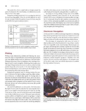
The s)'mbol for a fix is a small circle or triangle around the by 4,800, is the distance in feet to the bottom. The depth is nor-
point of intersection. For identification, it is labeled horizontally mally displayed both digitally and graphically on a small screCll.
with the time in four digits. Increasing use during piloting is being made of the satellile-
Navigation plotting symbols and their meanings are shown in b<lsed global positioning system described ill the Ilext section.
the accompanying graphic. When the symbols depicted are used, Modern GPS recei\'ers <lnd plotters incorpor;.lting them are capa-
it is not necessary to label the position (except for time), since the ble of continuously fixing the ship's position to '1Ccuracies of 10
symbol tells what type of position is shown. meters or better, and projecting highly accurate ekctronic plots of
the ship's future tJ'ilck. Such displays may in the future completely
replace the traditional manual plot kept on paper charts as the pri-
DESCRIPTIVE
SYI.IBOL MEANING mary navigation plot during piloting.
LABEL
0 '" AN ACCURAl E POSITION DETER'.'IIIED WITH·
OUT REFERENCE TOANY PREVIOUS POSlTIo.'I
6. CELESTIAL OBSERv~no:~s Electronic Navigation
ESTABUSHEOBY flEC1Ro,·'IIC. VISUAL OR
~ DR OEAORECKm.M~Gf'OSITiON AO':~t.'CEO As discllssed abO\'e, tradition<ll piJoting is dependent on obtaining
FAOI.IA PREVlQUS Kt~OMj f'OSITIO."1 OR FIX
COURSE ANDSPEEDAAE AECKO:,EOWITHOUT lines of bearillg and ranges from objects seen visually for the most
ALLO ... ·,),NCE FORWl:-':O OR CURRENT
part. Electronic lI(llligntiOl/, on the other hand, uses lines of position
0 " Esm.!ATED POSlTIQr-j IS THE MOST PROOABLE obtained b)' the use of mdio waves to determine a ship's position.
POSHlO~j OF A VESSEL. OETER'.'INED FAO.'.I
DATA OF OUEsn Q.'lABLE ACCUR~Y. SUCII AS The advantages of navigating by radio waves are several. A
APPLYING Esm.'AlED CURAEIIT AND I'.IND
CORRECTlONS TO A OR POSt TlQ:oI ship's position may be fixed electronically in fog or heavy weather
when it is impossible to take visual bearings. Electronic gear can
Standard plotting symbols are used by navigators, quartermasters, get ranges and bearings from stations or points fur beyond what
and CIC personnel to mark the ship's position along its track.
people can see from on board ship. Uut as marvelous as modern
electronics equipment is, it can still malfunction, or its power sup-
plies may fail. It is subject to jamming or destruction in wartime.
Piloting And even in today's environment of continually decreasing cost for
Piloting means determining position and directing the move- most electronic gear, sllch equipment is more expensive than Illost
ments of a ship by using landmarks, constructed navigational aids, traditional Illanual navigation equipment. Therefore, even " 'ith
and water depth readings made by a !athometer, described below. excellent electronic reception and equipment, the navigator must
Piloting is the primary means of navigation when entering or leav- still be able to make visual and celestial observations to establish
ing port and in coastal navigation. In piloting, the navigator gives the ship's position if necessary.
warnings of danger (rocks, shoal water, wrecks, etc.), fixes the ship's
position frequentl), and accuratel), on the basis of sightings taken
of aids and land features, and recommends what course to take to
the commanding officer and conning officer.
Navigational equipment used in piloting includes the com~
pass, to determine the ship's heading; a speed log, either mechan-
ical or electronic, to indicate ship's speed; the bearing circle, to
determine the di rection ofland features, buoys, and so on; charts,
which show the outlines of the shore, as well as the position of land
and seamarks, aids to navigation and the depths of W<lter; various
electronic devices; and various plotting instruments like parallel
rulers and dividers.
Also used is the !atllOmeter, or echo sOIlIIrier, which determines
the depth of water under the ship's keel by measuring the time it
takes a sOllnd signal to reach the bottom and return to the ship.
These operate on the basis of the fact that sound travels through
water at about 4,800 feet per second. (This speed varies with tem-
perature, salinity, and depth but is a good average figure.) A depth
finder sends out a sound signal, which bounces otT the ocean noor
A quartermaster on the aircraft carrier USS John F. Kennedy (eV 67)
and returns to the ship much like an echo. Then, half the time in
uses a bearing circle to obtain a true bearing to an object. (Anthony
seconds required for the sound to make the round trip, multiplied Riddle)