
Page 200 - NAVAL SCIENCE 3 TEXTBOOK
P. 200
206 NAVA L SKILLS
Buoy Numbering and Lights
Red buoys marking the right side of a channel bear even num-
bers, starting with the first buoy from seaward. Green channel
buoys, to the left of the channel coming from seaward, have odd
numbers. Banded or striped buoys are not l1umbered, but some
have letters identifying the name of the buoy, such as Governors
Island West End Shoal Bell Buo)' (GI) and East Rockawa), Inlet Bell
Buo)' (ER).
Red lights are used onl), on red channel buo)'s. Green lights
are onl), for green channel buo)'s. White lighls are Ihe onl), lighls
lIsed on preferred-channel (junction) or safe-water (mid-chan-
nel) buo)'s.
Characteristics of lights on lighted buo),s are as follows:
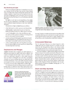
Daybeacon ranges in the Gaillard (Culebra) Cut of Ihe Panama Canal.
A fixed light may be 011 either a green or a red channel buoy.
Pilots conning ships transiting the canal do much of their steering
A flashing light. at regular intervals, not more than thirty Ihrough the canal on these daybeacon ranges.
flashes per minute, may also be on either a green or red buo),.
A quick-flashing light, no fewer than sLxt)' flashes per min-
the range." Ranges are valuable for pilots and conning officers who
ute, may be on either a green or red buoy at a turning point or
must guide ships along narrow channels. For example. much steer-
junction where special caution is required.
ing through the Panama Canal is done on ranges. Similarly, ranges
An inlerrupted quick-flashing light (repeated series of quick are used often on the Columbia RiveT in the Pacific Northwest.
flashes, separated by four-second dark intervals) may be on a
red and green horizontally banded preferred-channel buoy.
Intracoastal Waterway
A Morse A flashing light (short and a long flash, recurring al
the rate of about eight per minute) may be on a red and white The U.S. Intracoastal \,Vatcrway is an inland channel in which
vertically striped safe-water buoy. a light-draft vessel can navigate along the U.S. Atlantic and Gulf
coasts from the Chesapeake Bay almost to the Mexican border
without going into the ocean. The vessel can remain inside natural
Daybeacons and Ranges or artificial breakwaters for almost the entire length of the trip.
Unlighted structural aids to navigation are called dllybeacolls. A Every buoy, dayI1wrk, or light structure along the Intracoastal
da}'be<lcon may consist of a single wooden pile, or dolphin, with \,Vaterway has part of its surface painted yellow. Buoys have a yel-
a square or triangular daYlI/ark shape on top of it, a metal or con- low band at the top. Daymarks and other structures have a band
crete tower supporting a daymark, or other similar structures. or border of ),ellow. Red buo)'s and dal'l11arks arc 10 the right, and
They are colored to distinguish them from their surroundings. green to the left, as one proceeds from the Chesapeake Bay toward
Daymarks on beacons mnrking channels are colored and num- Mexico. Standard colors, numbers, and lights are used with navi-
bered like channel buoys. Those on the right coming from seaward gation aids in the waterway. Because the numbers would become
nrc triangular, and those on the left are square. ;vlallY have reflec- large in such a long line of buoys and daymarks, the)r are num-
tors that show the same colors as lighted buoys would at night. bered in groups of about two hundred, starting again at "1" at
'1\\'0 daybeacons.located some distance apart on a specific true natural dividing points.
bearing, make up a daybeacon mllge. \Vhen a ship reaches a posi-
tion where the two beacons are seen exactly in line. the ship is "on
Chart and Map Symbols
The publication Nautiml Chart SYIIlbols, Abbreviatiolls, alld 1erllls,
Drawings of daymarks that mark a
channel. Red triangular day marks with Chart No.1, available at most marine supply stores. contains expla-
sequential even numbers mark the right nations of the Ilumerous s}'l1lbols used on charts to identif)' prom-
side coming from seaward, and green inent features of coastlines. buildings and structures, bottom fea-
squares with sequential odd numbers tures, hazards to navigation. and depth contours. It also gh'es
mark the lett side.
information on the identification of danger signals, buo}'s, day-
beacons, lights, and radio and radar stations. NjROTC units have a
supply of Cllart No.1 for practical work in charting and piloting.