
Page 204 - NAVAL SCIENCE 3 TEXTBOOK
P. 204
210 NAVAL SKILLS
solar time at any moment is called the equation of time, It is tab- Zone time. Zone time (ZT) = standard time. Since local mean
ulated in navigational publications called almanacs, and must be time is based on the relationship between one's own meridian and
taken into account for certain tasks in celestial navigation at sea, the mean Sun, a slight difference in longitude between two places
Atomic time. Besides the above kinds of time that are based on would result in a slight difference in time kept. Though not very
the relationship of the Earth and the Sun, there is one other more significant in days of old, this difference would be very impractical
modern base for time that is coming into ever wider use because in our modern world. For exarnple, if we set our watches to local
of its extreme accuracy, This is atomic time, called universal coor- mean time (LMT), we would have to reset them every few blocks
dillated time, abbreviated as UTe. This time is based on the fre- along an east-west street. In New York City, for instance, a difter-
quency of vibrations of the radioactive cesium atom. Because ence of about nine seconds LMT occurs between one end of 42nd
cesium is a fairly common element, it is readily available to be Street and the other end.
used in atomic clocks as a time standard everywhere on Earth. Since To eliminate this problem, standard time zones have been
GMT is based on the changing relative motion of the Earth and established around the world. All clocks and watches within a stan-
the Sun, and UTe is based on the unchanging cesium frequency, dard time zone are set to the same time, and there is a difference
GJ\'fT and UTe can difter at certain times by as much as nine- of one hour between one time zone and the next. Because there
0
tenths of a second. But the difterence is usually smaller, and can are twenty-four hours in a complete day, and 360 of longitude
be disregarded for most navigational purposes. For more precise around the Earth, each standard time zone is 15 degrees of longi-
needs, the amount of difference at any time is readily available; so tude wide (360 + 24 = IS). The standard time zone system is fixed
the user can easily correct UTC to GMT, or vice versa, by international agreement and by law in each country.
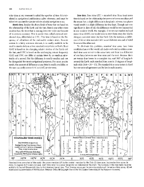
LI\1i Y X W V U c,n E H I K L ,y
~''''''Ii'-V
'.
M
Y'
:\V
• '.' >.
I
W' u s
M
M
STANDARD TIME ZONES M
0 h m h m h m h m h m
Z 0 E' +530 K +10 N -1 T ·7
Zone boundaries are appro:dmate +1
A F +6 K' +1030 P ., U -8
0
-2
Daylight Saving Time (Summer Time), B +2 F' +630 L +l! U' - 8 30
usually one hour in advance of Standard C +, 0 +7 L' +11 30 P' ·330 Y -9
Time, is kept in some places C' + 3 30 H +8 M +12 Q ·4 Y' -930
D +4 1 +9 M' +13 R ·5 W -10
Map outline © Mountain High Maps D' +430 I' + 9 30 Mt +14 S ·6 X -l!
Compiled by HM Nautical Almanac Office E +5 t No S!a.Ildard Time legally &dopt«! y -12 I
180' 150'W 120'W 90'W 60'W 30'W 0' 30'E 60'E 90'E 12 'E 150'E 180'
Standard time zone chart of the world, The prime meridian (00) is the centra! meridian for the Zulu (Z) time zone. Successive time zones lie
every 15 degrees to the east and west. Each time zone has a letter designator as indicated on the chart. The numbers in the inset table must be
added to Universal (Greenwich) time to find standard (zone) time. Their inverse values are the zone descriptions of the various time zones, (Chart
reproduced by permission of HM Nautical Almanac Office @ Copyright Council for the Central Laboratory of the Research Councils)