
Page 222 - NS-2 Textbook
P. 222
OCEANOGRAPHY 217
ward motion. The waves align themselves with the bot- ing parallel to the beach in a definite flow and speed.
tom contours as well as conform to the general slope of Such cmrents carry scoming sediments to and from the
the coastline. When one part of the line develops drag beach out to deeper water. In the process, they may de-
and changes direction or bends because of shallower stroy the beach and make real estate along that area
water, this response is called refraction. Such information nearly worthless. They also sometimes create bars that
is very important when an amphibious assault is being become navigational hazards. Groins serve as dams to
planned. stop the movement of sediments by these cmrents. They
Engineers must also know the "\,\Tay water waves are may protect a given beach, but such interference with
bent so they can take advantage of natural phenomena natural processes may also result in more erosion farther
when designing structures to protect shorelines and har- down the beach from waves. Careful surveys must be
bors. They must know where the natural energy is con- made before such structures are built.
centrated and where it is weaker so they can build for Rip Currents. Rip currents are strong, seavvard-
greatest effect and economy. moving cmrents that occur along some shores. They re-
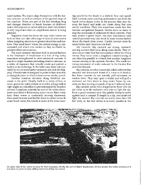
The most common structme built to protect harbors turn excess water that has been pushed ashore by strong
is the breakwater. A breakwater is a line of big rocks, waves. They occur when a longshore cunent moving in
sometimes strengthened by steel-reinforced concrete. It one direction parallel to a beach hits another longshore
may be a single structme protecting a harbor entrance, or cmrent moving in the opposite direction. The result is a
a series of segments that actually create and protect a strong movement of water outward to the breaker line
harbor or an anchorage. In the latter case, there will nor- and even beyond.
mally be two or more harbor entrances and exits for ship- Rip cmrents are often incorrectly called undertow (the
ping. A breakwater is designed to protect ships at anchor seaward and downward thrust of a wave as it breaks).
or alongside piers in a harbor from waves, swells, or sluf. But these currents do not actually pull swimmers or
Another common structure along inhabited sea- waders dowll. They may upset a wader and will pull a
coasts is the groin. Usually built in a series of two or swinuner out from shore to deep 'vater. Some rip cur-
more, groins are walls of stone or wooden pilings built at rents are fast, moving at speeds of up to 2 miles an hom.
right angles to a shoreline to prevent erosion by longshore Rip cmrents can be very dangerous to those who do
Clirrents. Longshore currents are part of the water move- not swim or to the swimmer who tries to fight the rip.
ment associated with incoming ocean waves. Since -water Even a good swimmer may tire quickly trying to swim
from these waves is continually moving shoreward, against such a cmrent. If caught in a rip, you must not
there must be some way for this water to return to sea. In fight the cmrent. Rip cmrents are rarely more than 100
many beach areas, this results in some of the water mov- feet wide, so the best advice is to swim parallel to the
An aerial view of the harbor entrance for Port Everglades, Florida, the port of Miami. Breakwaters of rocks protect the harbor entrance and
also serve as groins to keep shifting sands from filling the channeL