
Page 226 - NS-2 Textbook
P. 226
OCEANOGRAPHY 221
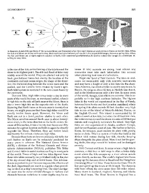
A ~JEAP TIDE
() \\
FjrltOuart~r
\ \
Full r,~oon 6- -()----
SPRING TIDE SPRING TIDE
()
New Moon
NEAP TIDE
()
L~1t QU"tH
In diagrams A and B the positions of the Sun and Moon are illustrated when they exert maximum and minimum forces on Earth's tides. When
the Sun and Moon are in line with each other, their combined gravitational pull results in the largest tidal ranges, known as spring tides. When
the Sun and Moon are at right angles in relation to Earth, their combined gravitational pulls tend to reduce tidal ranges to a minimum, re-
sulting in neap tides.
is the rise of the tide, or the flowing of the tide toward the treme. If tidal currents are strong, boat officers and
shore to its highest point. The ebb and flood of tides vary coxswains lunst take such information into accolmt
widely around the world. They are affected not only by when planning boat runs and schedules.
basic gravitational forces but also by the location of the Height a11d Speed of Tidal Curreilts. The tides in mid-
continents and mid-ocean ridges, the shape of the shore- ocean are nleasurable only with scientific instruments
line, the frictional drag between the water mass and the and may have a height of only a few feet. On the shore-
seabed, and the Coriolis force created by Earth's spin. lines, howevel~ the effect of tides is usually easy to see. In
Each tidal system is restricted to its own ocean basin by Boston, the range is about 12 feet, in Norfolk less than 6,
the continents. and in the Mediterranean only a few feet. In some areas
Time a11d Tides. High tides occur twice a day in most of the world, though, tidal effects are extreme. This is es-
parts of the """arld because, as mentioned earliel~ -when it pecially so in the high northern latitudes. TIle highest
is high tide on the side of Earth nearest the Moon, there is tides in the world are experienced in the Bay of Fundy,
also a lower high tide on the opposite side of the Earth. between Nova Scotia and the Canadian mainland, ·where
Knowing that Earth turns on its axis once in twenty-four the spring tide often exceeds 50 feet. Another very high
hours, we might presume that these high tides would be tide occurs at the island of Mont-St.-Michel, France, all
exactly tvvelve hours apart. However, the Moon and the English Channel. TIlis island is surroLmded by 10
Earth are not in a fixed position relative to each other. miles of sands at low tide, but when the 41-foot tide rises,
The Moon revolves around Earth once in about twenty- the water moves toward the shore at a rate of 210 feet per
seven days, in the same direction as the Earth rotates. Be- minute and completely surrounds the island. VelY high
cause of this motion, it takes twenty-four hours and fifty tides are also experienced in Alaska, northern Europe,
minutes for a given location on Earth to again be directly and the northeastern coast of Asia. The harbor at Inchon,
opposite the Moon. Therefore, there are twelve hours Korea, for instance, must enclose its piers "with gravi1lg
and twenty-five minutes between high tides. basiils or docks. This is a system of locks that hold in the
Because these facts are known precisely, tide tables for 40-foot tidal waters during low tide, thereby keeping
each harbor on Earth can be accurately predicted for ships alongside the piers afloat. Were it not for the grav-
many years in advance. The National Ocean Service ing docks, the ships would hit boltom and be damaged
(NOS), a division of the National Oceanic and Atmo- severely.
spheric Administration (NOAA), publishes Tide Tables Tidal Currellts aild Bores. In areas where a high tide is
and Curreilt Tables to assist mariners sailing in most parts common, a tidal bore or tidal surge is often a twice-daily
of the world. Times of high and low tides figured from event INhere the tide sweeps up a river ,vhose mouth
these tide tables normally are published daily in the plail opens directly on the sea. The world's highest tidal bores
of the day aboard ship and at naval bases. This informa- sweep up the Amazon River in Brazil and the Hangchow
tion is important in port because responsible officers and (Tsientang) River in Clllila. These bores rise from 15 to 25
the deck department can use it as a guide when provid- feet and speed up the rivers at 10-16 mph. The Amazon
ing for slack in a ship's mooring lines. The ship's naviga- tidal bore affects the river more than 300 miles inland.
tor must also be aware of tidal changes in harbors and Many rivers in Scotland, England, Nor-way, and Alaska
channels because variations in ,vater depths may be ex- have tidal bores. The River Severn in England has a