
Page 24 - GeoPRISMS_Newsletter_Spring2018_Neat
P. 24
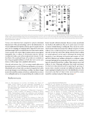
Figure 2. Map showing location of existing Holocene records of coseismic vertical deformation along the Hikurangi margin (Hayward et al., 2016).
        SHIRE Project paleoseismology study sites are located between 3-4, 4-5, and 7-8. Time line shows the estimated ages and accuracy limits for possible
        earthquake events known from existing record. Correlation lines between study sites are also shown on the map to indicate potential lateral extent
        of past earthquake ruptures..

        Terrace cover beds have been sampled for optically stimulated  buried beneath subtidal sediments. Because certain microfossils
        luminescence (OSL) geochronology, and for the identification of  have fidelity to the tidal frame, they can be used to assess how much
        volcanic tephra and loess deposits of known ages. During the next two  a coastline subsided during an earthquake. They can also be used to
        years, terrace mapping and sampling will be expanded to new areas  identify tsunami deposits because they indicate transport of marine
        and drone imagery will be recorded for structure-from-motion studies.  sediment into a coastal setting where such sediment does not occur
        Project students will conduct digital terrain analyses using regional  naturally. In this way, radiocarbon dating and microfossil analysis
        topographic data to evaluate net deformation patterns, calculate  on coastal sediments can be used to understand the timing and
        morphometric indices, and outline morphotectonic domains. Overall,   magnitude of past Hikurangi earthquakes and tsunamis. In 2017
        the efforts of the coastal uplift team will provide new constraints on   and 2018, Pilarczyk and students embarked on a sediment coring
        the timing and spatial distribution of both short-term seismic cycle   campaign that targeted low-energy depositional centers (i.e., marshes,
        events, as well as longer-term cumulative deformation.  lagoons) along the Hawke’s Bay coastline. Their mission was to find
        Pilarczyk and students (Fig. 3 G-I) are using coastal sediments to  evidence for past Hikurangi earthquakes that would supplement
        develop long-term records of Hikurangi earthquakes and tsunamis.  the short-term observational record by expanding the age range of
        Microfossils such as foraminifera are used to recognize both subtle  known events to include centennial and millennial timescales. The
        and abrupt changes in sea level along a coastline. An abrupt change  team’s ongoing investigations have led to the identification of newly
        in sea level, caused by coseismic subsidence, indicates the occurrence  discovered events that will help to better understand the seismic
        of an earthquake and can be recognized along the coastline as a soil  hazard for coastlines facing the Hikurangi margin. ■


            References


        Clark, K.J., B.W. Hayward, U.A. Cochran, L.M. Wallace, W.L. Power, A.T.   org/10.1080/03014220709510536.
            Sabaa,  (2015),  Evidence  for  past  subduction  earthquakes  at  a   Litchfield, N.J., U.A. Cochran, K.R. Berryman, K.J. Clark, B.G. McFadgen, R.
            plate  boundary  with  widespread  upper  plate  faulting:  Southern   Steele, (2016), Gisborne seismic and tsunami hazard: Constraints from
            Hikurangi Margin, New Zealand. Bull. Seismol. Soc. Am., 105. doi:   marine terraces at Puatai Beach GNS Science Report 2016-21, 99
            10.1785/0120140291                                 Morton,  J.,  (2018),  Our  sleeping  Taniwha:  Hikurangi’s  tsunami  threat.
        Cochran, U., K. Berryman, J. Zachariasen, D. Mildenhall, B. Hayward, K.   New Zealand Herald, 10 March 2018, https://www.nzherald.co.nz
            Southall,  C.  Hollis,  P.  Barker,  L.M.  Wallace,  B.  Alloway,  K.  Wilson,   Wallace,  L.M.,  M.  Reyners,  U.  Cochran,  S.  Bannister,  P.M.  Barnes,  K.
            (2006),  Paleoecological  insights  into  subduction  zone  earthquake   Berryman,  G.  Downes,  D.  Eberhart-Phillips,  A.  Fagereng,  S.  Ellis,
            occurrence, eastern North Island, New Zealand. Geol Soc Am Bull,   A.  Nicol,  R.  McCaffrey,  R.J.  Beavan,  S.  Henrys,  R.  Sutherland,
            118, 1051-1074, doi:10.1130/B25761.1                   D.H.N.  Barker,  N.  Litchfield,  J.  Townend,  R.  Robinson,  R.  Bell,
        Hayward, B.W., H.R. Grenfell, A.T. Sabaa, U.A. Cochran, K.J. Clark, L.M.   K.  Wilson,  W.  Power,  (2009),  Characterizing  the  seismogenic
            Wallace, A.S. Palmer, A.S., (2016), Salt-marsh foraminiferal record of   zone  of  a  major  plate  boundary  subduction  thrust:  Hikurangi
            10 large Holocene (last 7500 yr) earthquakes on a subducting plate   Margin,  New  Zealand.  Geochem  Geophys  Geosyst,  10,  Q10006.
            margin, Hawkes Bay, New Zealand: Geological Society of America   doi:10010.11029/12009GC002610
            Bulletin, v.128, p. 896-915, doi:10.1130/B31295.1  Wallace, L.M., U.A. Cochran, W.L. Power, K.J. Clark, (2014), Earthquake
        King,  D.N.T.,  J.  Goff,  A.  Skipper,  (2007),  Māori  environmental   and  tsunami  potential  of  the  Hikurangi  subduction  thrust,  New
            knowledge  and  natural  hazards  in  Aotearoa-New  Zealand.   Zealand insight from paleoseismology, GPS, and tsunami modelling.
            Journal  of  the  Royal  Society  of  New  Zealand,  37,  59-73,  doi.  Oceanography, 27, 104-117. doi:10.5670/oceanog.2014.46

        24  •  GeoPRISMS Newsletter  Issue No. 40  Spring 2018