
Page 10 - GeoPRISMS_Newsletter_Spring2019_42_Neat
P. 10
The Aleutian arc through and through:
How subduction dynamics influence the
generation, storage, and eruption of volatile-
bearing magmas
Daniel Rasmussen (LDEO, Columbia University), Terry Plank (LDEO, Columbia University),
Diana Roman (Carnegie Institution)
oes the volcano know about the slab? Our work in the central-eastern Aleutian arc seeks to address this question. Spanning from
Seguam volcano (west) to Shishaldin volcano (east), our corridor is marked by significant variations in magmatic water contents,
Dseismicity, deformation, and style and frequency of volcanism. By contrast, most subduction parameters, such as slab age and
velocity, remain constant. One significant exception is the depth of the slab below the frontal arc volcanoes, which transitions from a near
global minimum in the west (~65 km BSL) to a more typical depth in the east (~100 km BSL). This makes our corridor an ideal locality to
isolate the role of slab depth in driving magmatic processes. After a one-year-long seismic deployment, forty five-gallon buckets of new rock
samples, and one PhD dissertation, we are arriving at some answers.
The broad strokes of arc magma genesis are well 55°N Shishaldin
established: hydrated sediment and oceanic Rock samples Fisher
lithosphere subduct and release fluids and/ a Westdahl
or solids that drive melting of the overlying Makushin Akutan
mantle wedge, generating hydrous arc magmas 54°N Bogoslof
that ascend to regions of melt coalescence
either within or beneath the crust. However, Okmok
understanding transport and storage of magmas 150 km Vsevidof
in the crust represents a fundamental challenge 53°N 100 km Cleveland 6.9 cm/yr
to the study of evolution and eruption of Seguam
arc magmas. Recent development of several 50 km 7.0
geochemical and geophysical tools enables us to 52°N
closely track the path of magma through the crust, Alaska
particularly in the upper crust. We are employing 7.2 1.6 Kamchatka
2.4
these tools to illuminate the development and Bathymetry (km) 3.2 6.2 cm/a
eruption of upper crustal reservoirs and link these 51°N 7.3 100 km 4.1 7.8 AFZ 7.3 6.9
4.9
processes to arc magma genesis.
172°W 170°W 168°W 166°W 164°W 162°W
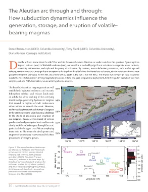
Figure 1. The central-eastern Aleutian arc. 60 40
(a) Map of our field area with historically Seguam 60
active volcanic centers labeled. Dashed 70 Seguam Vsevidof
lines are slab contours from Syracuse Cleveland 80
and Abers (2006). The Amlia Fracture 80 Akutan Shishaldin 100
Zone (AFZ) is shown in the inset map. (b) Okmok
Results of our new slab depth analyses for Slab depth (km) 90 Westdahl Bogoslof 120
volcanoes studied here (colored symbols) Makushin 140 Depth to slab (km)
and other volcanic centers (gray symbols). Bogoslof
(c) Histogram of slab depths beneath arc 100 (132 km) Fisher 160
frontal arc volcanoes worldwide from b Shishaldin 180
Syracuse and Abers (2006). 110
172 170 168 166 164 C 200
Longitude (°W)
220
10 • GeoPRISMS Newsletter Issue No. 42 Spring 2019