
Page 226 - (DK Eyewitness) Travel Guide 2017 - Alaska
P. 226
224 ALASK A AREA B Y AREA
4 Gates of the
Arctic National Park
200 miles (320 km) NW of Fairbanks.
Transport map D1. ~ to Anaktuvuk
Pass, Bettles, Coldfoot, or Kotzebue,
then bush plane. @ tour bus to
Coldfoot, then bush plane. n Bettles
Visitors’ Center, 692-5494. Also
Anaktuvuk Pass Ranger Station &
Arctic Inter agency Visitors’ Center
(Coldfoot). Note: no roads or facili ties
in national park. ∑ nps.gov/gaar
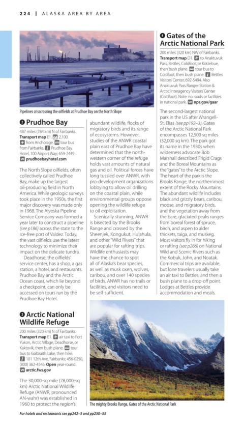
Pipelines crisscrossing the oilfields at Prudhoe Bay on the North Slope The second-largest national
park in the US after Wrangell-
2 Prudhoe Bay abundant wildlife, flocks of St. Elias (see pp192–3), Gates
migratory birds and its range of the Arctic National Park
487 miles (784 km) N of Fairbanks.
Transport map E1. * 2,100. of ecosystems. However, encompasses 12,500 sq miles
~ from Anchorage. @ tour bus studies of the ANWR coastal (32,000 sq km). The park got
from Fairbanks. n Prudhoe Bay plain east of Prudhoe Bay have its name in the 1930s when
Hotel, 100 Airport Way; 659-2449. determined that the north- wilderness advocate Bob
∑ prudhoebayhotel.com western corner of the refuge Marshall described Frigid Crags
holds vast amounts of natural and the Boreal Mountains as
The North Slope oilfields, often gas and oil. Political forces have the “gates” to the Arctic Slope.
collectively called Prudhoe long tussled over ANWR, with The heart of the park is the
Bay, make up the largest pro-development organizations Brooks Range, the northern most
oil-producing field in North lobbying to allow oil drilling extent of the Rocky Mountains.
America. While geo logic surveys on the coastal plain, while The abundant wildlife includes
took place in the 1950s, the first environmental groups oppose black and grizzly bears, caribou,
major discovery was made only opening the wildlife refuge moose, and migratory birds,
in 1968. The Alyeska Pipeline to oil exploitation. and the vege tation away from
Service Company was formed a Scenically stunning, ANWR the bare, glaciated peaks ranges
year later to construct a pipeline is bisected by the Brooks from boreal for est of spruce,
(see p186) across the state to the Range and crossed by the birch, and aspen to alder
ice-free port of Valdez. Today, Sheenjek, Kongukut, Hulahula, thickets, taiga, and muskeg.
the vast oilfields use the latest and other “Wild Rivers” that Most visitors fly in for hiking
tech nology to minimize their are popular for raft ing trips. or rafting (see p266) on National
impact on the delicate tundra. Wildlife enthusiasts may Wild and Scenic Rivers such as
Deadhorse, the oilfields’ have the chance to spot the Kobuk, John, and Noa tak.
service center, has a shop, a gas all of Alaska’s bear species, Commercial trips are avail able,
station, a hotel, and restaurants. as well as musk oxen, wolves, but lone travel ers usually take
Prudhoe Bay and the Arctic caribou, and over 140 species an air taxi to Bettles, and then a
Ocean coast, which lie beyond of birds. ANWR has no trails or bush plane to a drop-off point.
a checkpoint, can only be facilities, and visitors need to Lodges at Bettles provide
accessed on tours run by the be self-sufficient. accommodation and meals.
Prudhoe Bay Hotel.
3 Arctic National
Wildlife Refuge
200 miles (320 km) N of Fairbanks.
Transport map E1. ~ air taxi to Fort
Yukon, Arctic Village, Deadhorse, or
Kaktovik, then bush plane. @ tour
bus to Galbraith Lake, then hike.
n 101 12th Ave, Fairbanks; 456-0250,
(800) 362-4546. Open year-round.
∑ arctic.fws.gov
The 30,000-sq mile (78,000-sq
km) Arctic National Wildlife
Refuge (ANWR, pronounced
AN-wahr) was established in
1960 to protect the region’s The mighty Brooks Range, Gates of the Arctic National Park
For hotels and restaurants see pp242–5 and pp250–55
224-225_EW_Alaska.indd 224 02/05/17 2:32 pm