
Page 432 - (DK) Ocean - The Definitive Visual Guide
P. 432
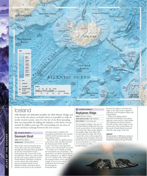
430 A B C D E F
35˚W 30˚W 25˚W 20˚W 15˚W 10˚W 5˚W
Arctic Circle
Greenland–Iceland Kolbeinsey Ridge Iceland Plateau
D e n m a r k S t r a i t Sea
GREENLAND Rise Norwegian Arctic Circle
1 19m 1
Ammassalik (46ft)
Viking Trough
65˚N (187ft) Hunaflói
57m
Akureyri Aegir Ridge 65˚N
Sermilik
Breidhafjördhur
Valley
2,460m
(8,071ft) Faxaflói ICELAND
3,300m
Reykjanes Reykjavik 251m (10,827t)
94m
2 Basin Keflavik Thjórsá (308ft) (824ft) 2
3,070m
(10,073ft) Heimaey Faeroe–Iceland Ridge
22m
(72ft) Surtsey
KEY
e Faeroe
sea level g FAEROE Shelf
d ISLANDS Tórshavn
800 ft
(250 m) R i
1,600 ft 68m
(500 m) s (223ft)
3,300 ft e Faeroe Faeroe–Shetland
3 (1,000 m) n Iceland 174m Bank Trough 3
Faeroe Gap
6,500 ft a (571ft) Bill Baileys
(2,000 m) j Basin Bank
60˚N 1,690m Outer 60˚N
9,800 ft k (5,545ft) Bailey
(3,000 m) y Wyville Thomson Ridge
659m
16,400 ft e (2,162ft)
(5,000 m) R
ATLANTIC OCEAN
Rosemary
Cape
land Bank Wrath
2,933m George Bligh
seamount Bank
(9,623ft) Hebridean Shelf
sea depth SCALE H a t t o n R i d g e 5m Stornoway
4 maximum depth 0 50 100 150 200 250 km 505m (16ft) 4
on map (1,660ft) 101m Outer Hebrides
tectonic plate (331ft)
boundary 0 50 150 200 250 300 miles Hatton–Rockall Rockall
Basin Rockall UNITED
Bank KINGDOM
30˚W 25˚W 20˚W 15˚W 10˚W
A B C D E F
Iceland ATLANTIC OCEAN B3 become less distinct away from the
ridge, as the older crust is draped in
Reykjanes Ridge sediment in the Reykjanes Basin and
THE ISLAND OF ICELAND straddles the Mid-Atlantic Ridge and Iceland Basin.
LENGTH 930 miles (1,500 km) Before this rifting started,
is one of the few places on Earth where it is possible to walk on
HEIGHT ABOVE SEA FLOOR 6,500 ft (2,000 m) Greenland and Britain were almost
newly created oceanic crust. It is the site of sea floor spreading adjacent, connected by a land bridge.
RATE OF SPREAD / 4 in (1.8 cm) per year
3
that was responsible for linking the Atlantic to the Arctic Ocean The Hebrides and Faeroe Islands,
around 36 million years ago. The surrounding seas are areas of The Reykjanes Ridge is the part of Rockall, and the other banks on the
the Mid-Atlantic Ridge that rises up eastern side of the Iceland Basin are
water and heat exchange between the two oceans. to the ocean surface to the southwest the result of basalt floods associated
of Iceland. The ridge clearly displays with the early stages of the rift.
of Iceland until it overflows the the parallel ridges and valleys that
ATLANTIC OCEAN B1 Greenland–Iceland Rise and cascades are left behind on either side of the SURTSEY
ATLAS OF THE OCEANS MINIMUM WIDTH 180 miles (290 km) the deepest parts of the world’s (1–2 cm) per year. The
6,500 ft (2,000 m) down into the
Denmark Strait
central rift as the sea floor spreads at
Surtsey was born in 1963 when a volcano on
a divergent plate boundary. Here, the
main Atlantic basin.
the western flank of the Mid-Atlantic Ridge
LENGTH 300 miles (480 km)
This is the start of a global journey
breached the surface of the sea off Iceland.
North American and Eurasian plates
are moving apart at /2–1 in
as the dense water circulates around
1
oceans—the deep-water leg of the
Most of the water leaving the Arctic
parallel features
“great ocean conveyor belt” (see p.61).
Ocean flows into the north Atlantic
In winter, sea ice builds up along
through the Denmark Strait, propelled
the Greenland coast. Sometimes, cold
by the East Greenland Current.
Icebergs from the eastern side of the
winds blow east off the Greenland Ice
Sheet, pushing sea ice offshore. More
Greenland Ice Sheet are carried south
by this cold current, while the warm
sea ice is created as the wind cools
the exposed surface water, and a
North Atlantic Drift flows northeast
on the eastern side of the island,
tongue of sea ice can extend
between Iceland and the Faeroe
south from the Greenland
Islands. At depth, cold, dense Arctic
Sea through the
bottom water pools to the northeast
Denmark Strait.