Page 434 - (DK) Ocean - The Definitive Visual Guide
P. 434

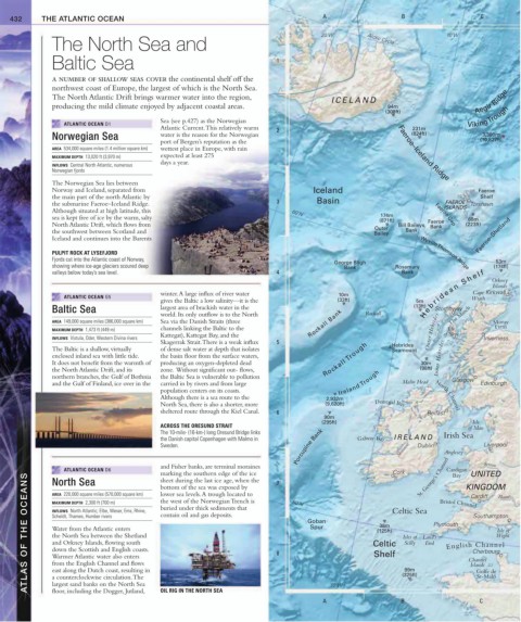
432     THE ATLANTIC OCEAN                                                            A                    B                     C


                                                                                         20˚W         Arctic Circle         10˚W
               The North Sea and

               Baltic Sea                                                    1

               a number of shallow seas cover the continental shelf off the
               northwest coast of Europe, the largest of which is the North Sea.
               The North Atlantic Drift brings warmer water into the region,
                                                                                            ICELAND                                Aegir Ridge
               producing the mild climate enjoyed by adjacent coastal areas.                               94m
                                                                                                           (308ft)               Viking  Trough
                                             Sea (see p.427) as the Norwegian
                  ATLANTIC OCEAN D1
                                             Atlantic Current. This relatively warm   2                           231m
                                                                                                                                     3,300m
               Norwegian Sea                 water is the reason for the Norwegian                                (824ft)            (10,827ft)
                                             port of Bergen’s reputation as the
               AREA  534,000 square miles (1.4 million square km)  wettest place in Europe, with rain         Faeroe–Iceland Ridge
               MAXIMUM DEPTH  13,020 ft (3,970 m)  expected at least 275
                                             days a year.
               INFLOWS  Central North Atlantic, numerous
               Norwegian fjords
               The Norwegian Sea lies between
               Norway and Iceland, separated from                                      Iceland                                      Faeroe
               the main part of the north Atlantic by                                   Basin                                        Shelf
                                                                                                                           FAEROE
               the submarine Faeroe–Iceland Ridge.                           3                                             ISLANDS  Tórshavn
               Although situated at high latitude, this
                                                                                 60˚N                    174m           Faeroe Gap
               sea is kept free of ice by the warm, salty                                                (871ft)                 68m
               North Atlantic Drift, which flows from                                                         Bill Baileys  Faeroe  (223ft)
                                                                                                        Outer          Bank
               the southwest between Scotland and                                                       Bailey  Bank                Faeroe–Shetland
               Iceland and continues into the Barents
               PULPIT ROCK AT LYSEFJORD                                                                             Wyville  Thomson Ridge
               Fjords cut into the Atlantic coast of Norway,                                 George Bligh                                53m
               showing where ice-age glaciers scoured deep                                     Bank          Rosemary                   (174ft)
               valleys below today’s sea level.                              4                                 Bank                     Orkney


                                                                                                                                   Cape Kirkwall
                                             winter. A large influx of river water            10m                  (13ft) b r i d e a n   S h e l f  Islands
                  ATLANTIC OCEAN G5                                                                                               Wrath
                                             gives the Baltic a low salinity—it is the        (33ft)               5m
                                                                                                                             The Minch
               Baltic Sea                    largest area of brackish water in the
                                             world. Its only outflow is to the North                 Rockall         H e Stornoway
               AREA  149,000 square miles (386,000 square km)  Sea via the Danish Straits (three   Rockall Bank                         Moray
               MAXIMUM DEPTH  1,473 ft (449 m)  channels linking the Baltic to the                                     Outer Hebrides  Isle  Firth
                                             Kattegat), Kattegat Bay, and the                                              of Skye
               INFLOWS  Vistula, Oder, Western Divina rivers                                                                          Inverness
                                             Skagerrak Strait. There is a weak influx   5                    Hebrides
               The Baltic is a shallow, virtually   of dense salt water at depth that isolates               Seamount
               enclosed inland sea with little tide.    the basin floor from the surface waters,                         Inner Hebrides
               It does not benefit from the warmth of   producing an oxygen-depleted dead   Rockall Trough          30m
               the North Atlantic Drift, and its   zone.  Without significant out- flows,                           (98ft)
               northern branches, the Gulf of Bothnia   the Baltic Sea is vulnerable to pollution                            Glasgow
               and the Gulf of Finland, ice over in the   carried in by rivers and from large   Ireland Trough  Malin Head           Edinburgh
                                             population centers on its coasts.
                                             Although there is a sea route to the         2,932m                         North Channel
                                             North Sea, there is also a shorter, more     (9,620ft)     Donegal Bay
                                             sheltered route through the Kiel Canal.  6                               Belfast
                                                                                          90m
                                                                                         (295ft)                                   Isle
                                             ACROSS THE ORESUND STRAIT                                                           of Man
                                                                                  Porcupine Bank              Shannon      Anglesey
                                             The 10-mile- (16-km-) long Oresund Bridge links                               Irish Sea
                                             the Danish capital Copenhagen with Malmo in           Galway Bay  IRELAND
                                             Sweden.                                                               Dublin             Liverpool
                                             and Fisher banks, are terminal moraines                                                  Severn
                  ATLANTIC OCEAN D6          marking the southern edge of the ice   7                        Cork   St. George’s Channel  Cardigan KINGDOM
                                                                                                                                  UNITED
        ATLAS OF THE OCEANS  MAXIMUM DEPTH  2,300 ft (700 m)  buried under thick sediments that   8  50˚N  Goban  Celtic  Isles of  Land’s Plymouth  Channel  Wight
                                                                                                                             Bay
               North Sea
                                             sheet during the last ice age, when the
                                             bottom of the sea was exposed by
               AREA  220,000 square miles (570,000 square km)
                                             lower sea levels. A trough located to
                                                                                                                                  Cardiff
                                                                                                                                         Thames
                                             the west of the Norwegian Trench is
                                                                                                                          Bristol Channel
                                                                                                             Celtic Sea
               INFLOWS  North Atlantic; Elbe, Weser, Ems, Rhine,
                                             contain oil and gas deposits.
                                                                                                                                   Southampton
               Scheldt, Thames, Humber rivers
                                                                                                         38m
                                                                                      Spur
               Water from the Atlantic enters
                                                                                                                                         Isle of
                                                                                                        (125ft)
               the North Sea between the Shetland
               and Orkney Islands, flowing south
                                                                                                                Scilly
                                                                                                                      End
                                                                                                                            English Channel
               down the Scottish and English coasts.
                                                                                                                                   Cherbourg
                                                                                                        Shelf
               Warmer Atlantic water also enters
               from the English Channel and flows
                                                                                                                                  Islands
               east along the Dutch coast, resulting in
                                                                                                                99m
                                                                                                                                    St-Malo
               a counterclockwise circulation. The
               largest sand banks on the North Sea
               floor, including the Dogger, Jutland,
                                             OIL RIG IN THE NORTH SEA
                                                                                          A  10˚W              B (325ft)            Golfe de
                                                                                                                                     C
   429   430   431   432   433   434   435   436   437   438   439