Page 433 - (DK) Ocean - The Definitive Visual Guide
P. 433

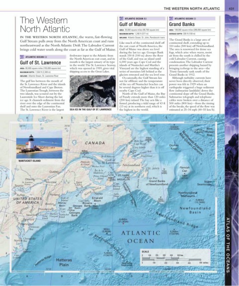
THE WESTERN NORTH ATLANTIC             431


             The Western                                                    ATLANTIC OCEAN B3            ATLANTIC OCEAN E2
                                                                        Gulf of Maine                 Grand Banks
             North Atlantic                                             AREA  35,000 square miles (90,700 square km)  AREA  108,000 square miles (280,000 square km)
                                                                        MAXIMUM DEPTH  1,240 ft (377 m)  AVERAGE DEPTH  330 ft (100 m)
             IN THE WESTERN NORTH ATLANTIC, the warm, fast-flowing      INFLOWS  Atlantic Ocean; St. John, Penobscott rivers
             Gulf Stream pulls away from the North American coast and runs                            The Grand Banks is a large area of
                                                                        Like much of the continental shelf off   continental shelf, extending up to
             northeastward as the North Atlantic Drift. The Labrador Current   the east coast of North America, the   310 miles (500 km) off Newfoundland.
             brings cold water south along the coast as far as the Gulf of Maine.  Gulf of Maine was above sea level   The area is renowned for dense sea
                                                                        during the last ice age. Georges Bank   fogs, which arise when warm, moist
                                           freshwater input to the Atlantic from   stands 330 ft (100 m) above the floor   air from the south is chilled by the
                ATLANTIC OCEAN C2
                                           the North American east coast, and its   of the Gulf, and was an island until   cold Labrador Current, causing
             Gulf of St. Lawrence          mouth is the largest estuary of its type   6,000 years ago. Cape Cod and the   condensation. The Labrador Current
                                           in the world. The St. Lawrence Seaway,  islands of Nantucket and Martha’s   presents another shipping hazard by
             AREA  60,000 square miles (155,000 square km)  which was opened in 1959, gives vital   Vineyard are the highest standing of a   bringing icebergs to the area—the
             MAXIMUM DEPTH  7,550 ft (2,300 m)  shipping access to the Great Lakes.   series of moraines left behind as the   Titanic famously sank south of the
                                                                        glaciers retreated and the sea level rose.  Grand Banks in 1912.
             INFLOWS  Atlantic Ocean, St. Lawrence River
                                                                          Occasionally, the Gulf Stream lies   Although turbidity currents have
             The gulf lies between the mouth of                         not far offshore and the temperature   never been directly observed, their
             the St. Lawrence River and the islands                     of the sea off Nantucket beaches can   power was felt in 1929 when an
             of Newfoundland and Cape Breton.                           be several degrees higher than it is off   earthquake triggered a huge sediment
             The Laurentian Trough, between the                         nearby Cape Cod.              flow (submarine landslide) down the
             two islands, was scoured out by the                          North of the Gulf of Maine, the Bay   continental slope off the Grand Banks.
             Laurentide Ice Sheet during the last                       of Fundy extends more than 120 miles  Submarine telegraph and telephone
             ice age. It channels sediment from the                     (200 km) inland. The bay acts like a   cables were broken over a distance of
             river over the edge of the continental                     funnel, producing a tidal range of 43 ft   500 miles (800 km)—from the timing
             shelf and onto the Laurentian Fan.                         (13 m) at its northern end, which is   of the breaks, the speed of the flow was
             The St. Lawrence River is the largest   SEA ICE IN THE GULF OF ST. LAWRENCE  the highest in the world.   estimated at 25–34 mph (40–55 km/h).


                 A                    B                   C                    D                    E                    F

             80˚W                       70˚W                      60˚W                     50˚W                       40˚W
                                                                                                       3,826m
                                                                                                      (12,553ft)     2,273m  West
                                                                                                                     (7,458ft) Thulean
                                                                                                                             Rise
                                                                                        119m
    1                                                                            Belle Isle  (390ft)          Northwest Atlantic     1
                                                    CANAD A               Strait of   Belle Isle Cape Bauld  Orphan  Mid–Ocean Canyon   50˚N
                                        50˚N                                     Grey Islands          Knoll
                                                  309m                         White
                                                 (1,014ft)                      Bay Notre Dame Bay
                                                             Île d’Anticosti         Fogo Island
                                                                Gulf of
            NANTUCKET ISLAND                      Honguedo Passage St. Lawrence
                                                 Péninsule
                                                 de Gaspé                 Newfoundland
                                                        Rocher Percé
                                                                                         St. John’s         Flemish
                                                         Îles de la  Cabot Strait ST. PIERRE                  Cap
                              Québec                                                              13m
                                                                  Cape
                                                         Madeleine  North                         (43ft)
                                                                                                              126m
    2                        St. Lawrence                Prince Edward  466m  AND        Cape Race           (413ft)                 2
                                                           Island
                Ottawa                                           (1,529ft) MIQUELON
              St. Lawrence  Montréal          Saint                                 Placentia Bay  Grand Banks             Milne
               Seaway                                                Cape               of Newfoundland                Seamounts
         Toronto                              John                  Breton
                                                    Nova Scotia
             Lake                                                    Island  Trough
            Ontario                            Bay of Fundy
                                                                           Laurentian
                                                                     Sable
           Buffalo           Connecticut Portland         Halifax    Island                                 Newfoundland
                                                                                                             Seamounts
         UNITED STATES               Gulf of    Cape Sable  Emerald            Laurentian       63m                   3,883m
                                      Maine
                                                         Basin
           OF AMERICA     Hudson  Boston  Murray  Georges Bank  69m            Fan             (207ft)                (12,740ft)
                                                  Browns
                                    Basin
              Susquehanna  Delaware  Providence  Cape  (10ft)  Basin  (226ft)                                Newfoundland
                                          3m
         40˚N                  Martha’s  Cod  Georges                                                             Basin
    3           New York  Long Vineyard  Nantucket  Bank                                                                       40˚N  3
                                    Island
                          Island
              Baltimore                                                 6,492m                N e w f o u n d l a n d   R i d g e
                                                                        (21,300ft)
         Potomac
             Washington
                   Delaware
                   Bay                                         903m
                                                              (2,963ft)                                5,356m
                                                                          ATLANTIC                    (17,573ft)
               Chesapeake
         Norfolk  Bay                                                        OCEAN
               Cape                                      New England Seamounts                                                           ATLAS OF THE OCEANS
               Hatteras                                                               SCALE
    4                                                          5,464m                                                                4
         Cape                                                  (17,927ft)             0   100  200  300  400  500 km
                      Hatteras Ridge  Hatteras                            Nashville   0     100    200    300    400    500  miles
        Lookout
                                    Plain
                             70˚W                               60˚W     Seamount                   50˚W
                 A                    B                   C                    D                    E                    F
   428   429   430   431   432   433   434   435   436   437   438