Page 439 - (DK) Ocean - The Definitive Visual Guide
P. 439

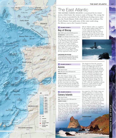
G                     H                     I                                                        THE EAST ATLANTIC         437


              10˚W  IRELAND                 UNITED       0˚
                                 Bristol Channel
     Porcupine Bank        Celtic Sea   Plymouth    Isle of Wight  50˚N  1  The East Atlantic
                        Cork
                                           KINGDOM
                                              English  Channel
                                                                        THE EASTERN NORTH ATLANTIC is renowned for its winter
       Porcupine Seabight  (125ft)  Isles of  Land’s  Channel  Cherbourg Seine  storms, which batter the western coasts of Europe. The energy for
                       38m
                              Scilly
                                  End       Islands                     these storms is provided by the Gulf Stream feeding warm water
                                               Golfe de                 into the North Atlantic Drift, which flows to the northeast. The
                                                St-Malo
         Goban           Celtic Shelf                                   North Atlantic Gyre pulls some of this water south along
          Spur
                                  99m      Brest                        the African coast as the Canaries Current.
                                 (325ft)          FRANCE
                                      Pointe            Loire
                                      du Raz                                                          full-size Atlantic rollers are amplified
                                            Belle Île  Nantes               ATLANTIC OCEAN I3         by the sudden shallow depth. There is
                                                                   2
                                                                        Bay of Biscay                 a weak counterclockwise surface
                                                   Île de Ré                                          current within the bay. The Charcot
                                                   Île d’Oléron         AREA  86,000 square miles (223,000 square km)  Seamounts, Azores–Biscay Rise, and
                                                                        MAXIMUM DEPTH  15,535 ft (4,735 m)  Kings Trough mark an inactive crustal
                         Biscay Plain Bay of                            INFLOWS  Loire, Dordogne, Garonne, Adour rivers  fracture where the sea floor was once
                                       Plateau de Rochebonne
                                                       Bordeaux                                       splitting apart.
                                     Biscay                             The Bay of Biscay lies between Brest,
                             4,870m
                            (15,978ft)                                  on the Brittany Peninsula, and the
        Charcot Seamounts                         Cabo    Biarritz  3   north coast of Spain. The northern
                                                                        half of the bay is quite shallow,
                 Theta Gap   Ortegal     Gijón Costa Verde de Ajo San Sebastián  overlying the continental shelf, but
                              Cabo
                                                                        this steeply drops away to the Biscay
                                                       Donostia–
                                              Santander
                                                                        Plain, which is a small, partially
                                                                        opened ocean basin. Ships crossing
                                La Coruña
                         Cabo                                           the bay experience heavy seas, as
            492m  Galicia  Fisterra  Vigo
           (1,614ft) Bank                      Douro                    LIGHTHOUSE ON THE BAY
                                                                        The Old Lighthouse at La Raz Cap is one of
                                                                        several that mark treacherous rocks off the
                                 Oporto                                 Brittany Peninsula in the Bay of Biscay.
                                                  SPAIN      40˚N  4
                            PORTUGAL
                                                                                                      The islands rise from the extensive
       Iberian Plain
                       Cabo Mondego       Tagus                             ATLANTIC OCEAN D5         Azores Plateau, an area of thickened
                   5,536m                                               Azores                        ocean crust. Although volcanic in
                  (18,164ft)                 Guadiana                                                 origin, the oldest islands also include
                                                                        TYPE  Volcanic islands        substantial accumulations of limestone
                                Lisbon                                                                and clay sediments. A mantle hotspot
                       Cabo de Roca                                     AREA  890 square miles (2,300 square km)  (see p.51) underlies the plateau and
                        Cabo Espichel           Guadalquivir            NUMBER OF ISLANDS  9          seems to be slowly spreading it apart
                          Cabo de Sines
                                                                   5    The Mid-Atlantic Ridge is the   at the Terceira Rift, a fracture that
                   Tagus           Algarve                              dominant seafloor feature in the   links the East Azores Fracture Zone
                   Gorringe Ridge
                   Plain    São Vicente  Gulf of  Gibraltar  Mediterranean  eastern Atlantic region, with a central   to the Mid-Atlantic Ridge. The last
                                         Cadiz
                              Cabo de
                                                                        trough and numerous transform
                                                                                                      volcanic eruption in the Azores was
     Horseshoe  Gettysburg                Gibraltar  Tangiers  Sea      fracture zones. Just east of the ridge,   in 1957, when the Capelinhos volcano
                                          Strait of
      Seamounts
                                                                        the Azores island group straddles the
                                                                                                      produced a cinder island (an island
                                                    Ceuta
                                                                        triple junction between the Eurasian,
                                                                                                      composed of lava fractures called
               Seamount
                                                                        African, and North American plates.
                                                                                                      cinders) off Faial’s coast.
                  Ampere
                  Seamount                                         6                                  last erupted in 1909. Teide’s slopes are
                                          Rabat                             ATLANTIC OCEAN G8         unstable, and there is evidence that
                                                  KEY
        20m       Seine Plain      Casablanca           sea level       Canary Islands                huge landslides have occurred in the
       (66ft)                                                                                         past. There is also a risk that volcanic
                                                                        TYPE  Volcanic islands        activity or earth tremors could cause
                                                        800 ft
         Seine                                                                                        part of La Palma island to slip into the
       Seamount        4,265m                           (250 m)         AREA  2,900 square miles (7,400 square km)
                      (13,993ft)                        1,600 ft        NUMBER OF ISLANDS  7          sea, resulting in an enormous tsunami.
                                      Safi               (500 m)                                       Such an event would threaten the
                                                        3,300 ft        The name of these islands derives    coasts of the north Atlantic, including
                                                        (1,000 m)
                                                                        not from the yellow bird of the same   heavily populated parts of North
                                   MOROCCO              6,500 ft        name, but from the Latin word for   America, with inundation. The islands’
                                                        (2,000 m)  7
                                                        9,800 ft        dogs, Canaria. The islands are volcanic,   first volcanic eruptions in 40 years
           Dacia    Agadir Canyon                                       overlying a mantle hotspot. Pico del   occurred in 2011, under the sea off
        Seamount             Cap Rhir  Agadir           (3,000 m)       Teide on Tenerife is the third largest   El Hierro, the youngest and most
                    Conception                          (5,000 m)       volcano on Earth, rising more than   southwesterly of the islands.
                                                        16,400 ft
                       Bank
                                                                        12,000 ft (3,700 m)
                                                     land               above sea level, or           TENERIFE ISLAND
                                                                        almost 23,000 ft
                                                     seamount           (7,000 m) from                                                   ATLAS OF THE OCEANS
                 Lanzarote
    Canary Islands                                   sea depth          the sea floor. It
    Santa Cruz  Fuerteventura                        maximum depth   8
    Tenerife                                         on map
               Cap Juby
                                                     tectonic plate
    Las Palmas                                       boundary
                       WESTERN SAHARA
                                 10˚W
           G                     H                     I
   434   435   436   437   438   439   440   441   442   443   444