Page 442 - (DK) Ocean - The Definitive Visual Guide
P. 442

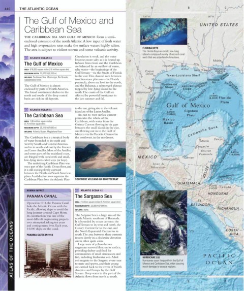
440     THE ATLANTIC OCEAN                                                           A                     B                     C


                                                                                     100ºW                                 90ºW
               The Gulf of Mexico and
                                                                                                                      UNITED S TATES
               Caribbean Sea                                                 1

               THE CARIBBEAN SEA AND GULF OF MEXICO form a semi-                                                        Mississippi
               enclosed extension of the north Atlantic. A low input of fresh water
               and high evaporation rates make the surface waters highly saline.
                                                                                     FLORIDA KEYS              Red River
               The area is subject to violent storms and some volcanic activity.
                                                                                     The Florida Keys are small, low-lying
                                                                                     islands composed mainly of ancient coral
                                             Circulation is weak, and the water
                  ATLANTIC OCEAN B3                                                  reefs that are underlain by limestone.
                                             becomes more salty as it is heated up.   2                                       Mobile
               The Gulf of Mexico            Inflows from rivers and the Caribbean                                30ºN
                                             are balanced by an outflow of warm,                Houston    Port
               AREA  618,000 square miles (1.6 million square km)  salty water—the beginnings of the   Corpus  Arthur  New Orleans  Mississippi-
                                                                                                                               Alabama
               MAXIMUM DEPTH  17,070 ft (5,203 m)  Gulf Stream—via the Straits of Florida   Rio Grande  Christi                 Shelf
                                             to the east. This channel runs between               Texas-Louisiana Shelf           De Soto
               INFLOWS  Caribbean Sea; Mississippi, Rio Grande,                                                                    Canyon
               Apalachicola rivers           two limestone plateaus—the Florida             Padre                          Mississippi
                                             peninsula, above sea level to the north,       Island                           Fan
                                                                                                                      Slope
               The Gulf of Mexico is almost   and the Bahamas, a submerged plateau              Northwest  Central  Mississippi        Florida
                                                                                                  Slope
               enclosed by parts of North America.   topped by low-lying islands to the   Brownsville       Slope                    Escarpment
               The broad continental shelves to the   south. The coasts of the Gulf are   Matamoros    S i g s b e e       E s c a r p m e n t
               north and south of the deep central   affected by powerful hurricanes in    3                                2,530m
               basin are rich in oil deposits.   the late summer and fall.              East Mexico Shelf                   (8,301ft)  Florida
                                                                                                                                  Plain
                                             to the east, giving rise to the volcanic   Tropic of Cancer  Gulf  of  Mexico
                  ATLANTIC OCEAN E6
                                             island arc of the Lesser Antilles.                    3,610m    Sigsbee
               The Caribbean Sea               An east-to-west surface current                    (11,844ft)   Plain
                                             permeates the whole of the
               AREA  1.06 million square miles   Caribbean, with water from the     Tampico     Mexico      Campeche  Escarpment
                                                                                                                                         Tongue
               (2.75 million square km)      Guiana Current flowing in via gaps                  Basin                                  Catoche
               MAXIMUM DEPTH  25,215 ft (7,685 m)  between the small islands in the east,   4  Tuxpán
               INFLOWS  Atlantic Ocean, Magdalena River  and flowing out in to the Gulf of                     C a m p e c h e   B a n k
                                             Mexico via the Yucatán Channel in   20ºN
               The Caribbean Sea is a tropical body   the northwest. in the northwest.                  Campeche Canyon               Yucatan Channel
               of water bounded to its south and                                                                      Mérida  Cancún
                                                                                                                                     Isla
               west by South and Central America,                                                                                   Cozumel
               and to its north and east by the Greater                           Veracruz       Bay of             Campeche
               and Lesser Antilles. Most of the Antilles,                                      Campeche               Yucatan
                                                                                                                                        4,407m
               and some parts of the mainland coast,                                                                  Peninsula    Yucatan Escarpment
                                                                                                                                        (14,459ft)
               are fringed with coral reefs and small,                            MEXICO                     Carmen
               low-lying islets called cays (or keys).                       5                  Coatzacoalcos
                 The underlying Caribbean Plate was                                       Istmo de
               once part of the Pacific Ocean floor, and                                 Tehuantepec
                                                                                                                            City
               it is still moving slowly eastward                                                                        BELIZE Belize
               between the North and South American                                                                         Barrier Reef
               plates. A subduction zone separates the                                                                            Swan  Trough
               Caribbean Plate from the Atlantic Plate   SOUFRIERE VOLCANO ON MONTSERRAT                                        Islas de la Bahía
                                                                                                         GUATEMALA
                                                                                                                           Puerto
                                                                                                                           Cortés  La Ceiba
                 HUMAN IMPACT                   ATLANTIC OCEAN H2
                                                                             6                                             HONDURAS
                 PANAMA CANAL                The Sargasso Sea
                                                                                                                     EL
                                             AREA  2 million square miles (5.2 million square km)
                 Opened in 1914, the Panama Canal
                 links the Atlantic Ocean with the   MAXIMUM DEPTH  23,000 ft (7,000 m)                          SALVADOR
                 Pacific, allowing ships to avoid the   INFLOWS  None                                                           NICARAGUA
                 long journey around Cape Horn.
                 Its construction was one of the   The Sargasso Sea is a large area of the
                 most difficult engineering projects   north Atlantic southeast of Bermuda.   7                 10ºN                 COSTA
                                             It is bounded by ocean currents: the
        ATLAS OF THE OCEANS  PANAMA GATES IN 1913  south. The area between these currents   8  HURRICANE LILI           P A CIFIC
                 ever attempted, taking ten years
                                             Gulf Stream to its west and north, the
                 and costing many lives. Each year,
                                             Canary Current far to the east, and
                 14,000 ships use the canal.
                                             the North Equatorial Current to its
                                                                                                                                         RICA
                                             rotates slowly in a clockwise direction
                                             and is often quite calm.
                                               Large mats of yellow-brown
                                             sargassum seaweed float on its surface,
                                             providing shelter and food for
                                             communities of small crustaceans and
                                             fish, including freshwater eels. Adult
                                             eels migrate to the Sargasso every year
                                                                                     Hurricanes occur frequently in the Gulf of
                                                                                                                          OCEAN
                                             to mate and spawn, and their young
                                                                                     Mexico and Caribbean Sea, often causing
                                             are carried back to the rivers of North
                                                                                     much damage to coastal regions.
                                             America and Europe by the Gulf
                                             Stream. Deep water in this part of the
                                             Atlantic flows from north to south.
                                                                                         A              90ºW   B                     C
   437   438   439   440   441   442   443   444   445   446   447