
Page 441 - (DK) Ocean - The Definitive Visual Guide
P. 441
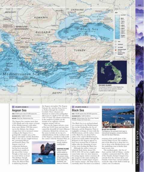
G H I J K L 439
Danube 20˚E 30˚E UKRAINE Taganrog 40˚E
MOLDOVA Mariupol’
HUNGARY Prut Dniester Mykolayiv Dnieper Gulf of Taganrog Don KEY
Kherson sea level
Odesa
ROMANIA RUSSIAN 800 ft 1
Drava Sea of Azov
CROATIA Danube Gulf of Karkinitt Crimean Kerch FEDERATION (250 m)
Sava
Yevpatoriya Peninsula Novorossiysk 1,600 ft
Sevastopol’ Kerch (500 m)
BOSNIA AND Constanta Crimea Strait 3,300 ft
HERZEGOVINA SERBIA AND Danube Danube Cone 2,267m Escarpment Caucasus (1,000 m)
MONTENEGRO Varna (7,438ft) Black Sea Escarpment 6,500 ft
2,155m (2,000 m)
9,800 ft
Dubrovnik BULGARIA (7,070ft) E u x i n e P l a i n (3,000 m)
1,695m
Maritsa Burgas West Black Sea (5,561ft)
Adriatic Escarpment Sinop 16,400 ft
Bosporus (5,000 m)
Basin East Black Sea
MACEDONIA Zonguldak Samsun Escarpment
Bari Durrës Istanbul land 2
Salonica Ordu Trabzon
Taranto ALBANIA Thracian Izmit
Chalkidiki Sea seamount
Sea of 40˚N
Gulf of Limos Dardanelles Marmara
Strait of Otranto
Taranto GREECE sea depth
Corfu Aegean Sea maximum depth
Lesbos TURKE Y on map
Apulian
Sporades
Chíos Izmir tectonic plate
Plateau
Athens Euboea boundary
Ionian Pátra
33m
Sea Peloponnese
Cyclades
Ionian Islands
Antalya Mersin
Mirtoo (108ft) Dodecanese
Ionian 5,095m Pelagos Sea of Crete Gulf of Iskenderun 3
Antalya
Basin (16,716ft) Cretan Trough Rhodes Rhodes Antalya Cilicia Trough Latakia
Basin
4,030m Hellenic Trough Crete Irákleio Karpathos Anaximander Basin
(13,222ft) 4,335m Ridge CYPRUS
Ptolemy Limassol
(14,223ft)
Strabo Trench
Seamounts
Mediterranean Sea Pliny Trench Herodotus Basin (2,077ft) Cyprus Tripoli
633m
Herodotus 1,269m Eratosthenes Basin Beirut
Seamount (4,163ft) Tablemount
Sir te Herodotus Trough LEBANON
Rise Mediterranean Ridge Levantine Basin Hefa
Darnah Herodotus Rise ISRAEL
Gulf of N i l e F a n Tel Aviv–Yafo VOLCANIC ISLANDS
Gulf of Sirte Benghazi Tubruq Salûm Gaza The islands of Santorini in the Aegean Sea 4
Alexandria Nile Delta Dead are the remains of an explosive volcanic
Sea
Surt Port Said Suez eruption about 3,500 years ago.
Canal
E GYPT
20˚E 30˚E Nile JORDAN
G H I J K L
the Aegean microplate. The Aegean
ATLANTIC OCEAN H2 ATLANTIC OCEAN J2
Volcanic Arc stretches from Greece
Aegean Sea to Turkey through the southern Black Sea
Cyclades. These volcanoes are
AREA 83,000 square miles (214,000 square km) dormant or extinct, but earthquakes AREA 163,000 square miles (422,000 square km)
MAXIMUM DEPTH 10,800 ft (3,294 m) still occur at a depth of 95–105 miles MAXIMUM DEPTH 7,200 ft (2,200 m)
(150–170 km). The islands of Santorini,
INFLOWS Black Sea, Mediterranean Sea INFLOWS Mediterranean Sea, Sea of Azov; Danube,
in the southern Cyclades, are the Dniester, Dnieper, Kizil Irmak rivers
The Aegean Sea contains more than remains of an explosive volcanic
1,000 islands and is the source of most eruption around 1640 bc. The Black Sea is an enclosed inland
of the Mediterranean’s cold, saline This was the largest volcanic event sea, connected to the Mediterranean
deep water. Before 1990 this source of the last 10,000 years and may have Sea via the Dardanelles, the Sea of
was in the Adriatic, but climate caused the downfall of Crete’s Minoan Marmara, and the Bosporus. There is BLACK SEA SHIPPING
changes have led to increased winter civilization. Behind the volcanic arc, negligible exchange of water with the The Bosporus, the narrowest strait open to
cooling in the Aegean. It is a the main Cyclades sit on top of a Mediterranean, and the surface waters international navigation, connects the Black
geologically complex area, as the subsided plateau. At the northern end of the Black Sea are about half as Sea with the Sea of Marmara.
Aegean microplate and the Anatolian of the Aegean, a transform fault marks saline as the eastern Mediterranean.
Plate to the east are caught between the contact with the Eurasian Plate, an A previous small outflow through the remnant of the north shore of the
the converging African area prone to Bosporus to the Aegean appears to ancient Tethys Ocean. The southern
and Eurasian plates. The strong, shallow have been reversed due to reduced part of the Black Sea is deep, but it is
Aegean crust is of earthquakes. inflow after the damming of some not as deep as the Mediterranean, and
continental thickness, of the rivers feeding the Black Sea. the underlying crust is thicker than
but has been stretched SKIATHOS ISLAND Although the surface waters are most ocean crust. ATLAS OF THE OCEANS
and thinned, notably in Aegean islands relatively fresh, below about 330– The northern parts—the Sea of
the area of the Cretan consist mostly of 490 ft (100–150 m) lies a highly saline Azov and the Gulf of Odessa—overlie
Trough, so that much of hard metamorphic water body with very slow turnover. a shallow continental shelf. The delta
it is now below sea level. and volcanic rocks, Decaying organic matter consumes all of the Danube, Europe’s longest river,
The Hellenic Trough so their coasts often the oxygen in this water, making the extends from the western shore, and
and Pliny Trench mark show steep cliffs, Black Sea the world’s largest oxygen- Danube waters have carried sediment
where the African Plate headlands, and free marine system—the deep water is across the edge of the shelf to build up
is subducting beneath wave-cut features. essentially dead. The basin is an isolated a thick cone of sediment.