
Page 446 - (DK) Ocean - The Definitive Visual Guide
P. 446
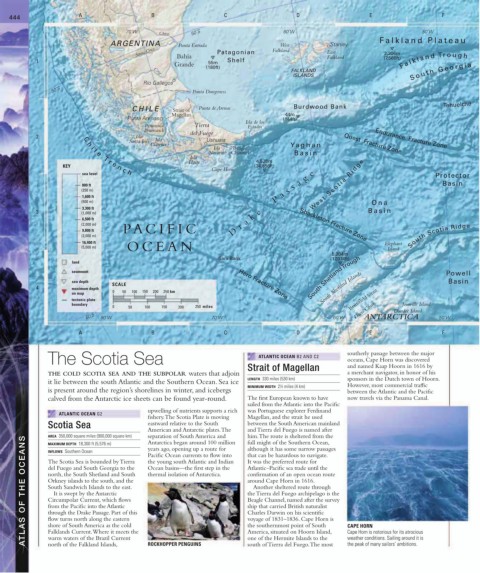
444 A B C D E F
70˚W Chico 50˚S 60˚W 50˚W
F alkland Plateau
ARGENTINA Punta Entrada West Stanley
Santa Cruz Bahía Patagonian Falkland East 2,306m
1 55m Shelf Falkland (7,566ft) F a l k l a n d Tr o u g h
Grande
(180ft)
FALKLAND S o u t h G e o r g i a
Coig
ISLANDS
Río Gallegos
50˚S Punta Dungeness
Tehuelche
CHILE Strait of Punta de Arenas Burdwood Bank
Magellan 44m
Punta Arenas (144ft)
Peninsula Tierra Isla de los
Estados
Brunswick
2 C Isla del Fuego Endurance Fracture Zone
Santa Inés Isla Ushuaia
h Clarence Yaghan Quest Fracture Zone
i Isla Beagle
l
Navarino Channel Basin
Isla
Hoste 4,528m
KEY (14,856ft)
Cape Horn
e T r e n c h
sea level g e Protector
a Basin
800 ft s We s t S c o t i a R i d g e
(250 m) s
1,600 ft a
(500 m) P Ona
3,300 ft
3 (1,000 m) e Basin
6,500 ft k
(2,000 m) r a Shackleton Fracture Zone
9,800 ft PA CIFIC D
(3,000 m) South Scotia Ridge
16,400 ft Elephant
(5,000 m) OCEAN Island
5,204m
Sars Bank (17,074ft)
land
seamount Powell
sea depth South Shetland Trough Basin
SCALE Hero Fracture Zone
4 maximum depth South Shetland Islands
on map 0 50 100 150 200 250 km
tectonic plate Bransfield Strait
boundary Joinville Island
0 50 100 150 200 250 miles Davis Coast Dundee Island
60˚S 80˚W 70˚W 60˚W ANTARCTICA 50˚W
A B C D E F
The Scotia Sea ATLANTIC OCEAN B2 AND C2 southerly passage between the major
oceans, Cape Horn was discovered
Strait of Magellan and named Kaap Hoorn in 1616 by
THE COLD SCOTIA SEA AND THE SUBPOLAR waters that adjoin a merchant navigator, in honor of his
LENGTH 330 miles (530 km) sponsors in the Dutch town of Hoorn.
it lie between the south Atlantic and the Southern Ocean. Sea ice
MINIMUM WIDTH 2½ miles (4 km) However, most commercial traffic
is present around the region’s shorelines in winter, and icebergs between the Atlantic and the Pacific
calved from the Antarctic ice sheets can be found year-round. The first European known to have now travels via the Panama Canal.
sailed from the Atlantic into the Pacific
upwelling of nutrients supports a rich was Portuguese explorer Ferdinand
ATLANTIC OCEAN G2
fishery. The Scotia Plate is moving Magellan, and the strait he used
Scotia Sea eastward relative to the South between the South American mainland
American and Antarctic plates. The and Tierra del Fuego is named after
separation of South America and
him. The route is sheltered from the
AREA 350,000 square miles (900,000 square km)
ATLAS OF THE OCEANS The Scotia Sea is bounded by Tierra the young south Atlantic and Indian It was the preferred route for CAPE HORN
Antarctica began around 100 million
full might of the Southern Ocean,
MAXIMUM DEPTH 18,300 ft (5,576 m)
although it has some narrow passages
years ago, opening up a route for
INFLOWS Southern Ocean
that can be hazardous to navigate.
Pacific Ocean currents to flow into
Atlantic–Pacific sea trade until the
del Fuego and South Georgia to the
Ocean basins—the first step in the
thermal isolation of Antarctica.
north, the South Shetland and South
confirmation of an open ocean route
Orkney islands to the south, and the
around Cape Horn in 1616.
South Sandwich Islands to the east.
Another sheltered route through
the Tierra del Fuego archipelago is the
It is swept by the Antarctic
Circumpolar Current, which flows
Beagle Channel, named after the survey
from the Pacific into the Atlantic
ship that carried British naturalist
through the Drake Passage. Part of this
Charles Darwin on his scientific
flow turns north along the eastern
voyage of 1831–1836. Cape Horn is
shore of South America as the cold
the southernmost point of South
America, situated on Hoorn Island,
Falklands Current. Where it meets the
Cape Horn is notorious for its atrocious
warm waters of the Brazil Current
one of the Hermite Islands to the
weather conditions. Sailing around it is
north of the Falkland Islands,
ROCKHOPPER PENGUINS
south of Tierra del Fuego. The most
the peak of many sailors’ ambitions.