
Page 467 - (DK) Ocean - The Definitive Visual Guide
P. 467
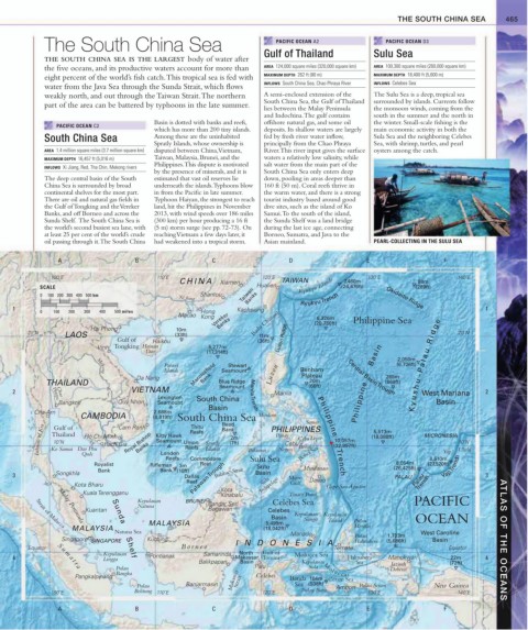
THE SOUTH CHINA SEA 465
The South China Sea PACIFIC OCEAN A2 PACIFIC OCEAN D3
THE SOUTH CHINA SEA IS THE LARGEST body of water after Gulf of Thailand Sulu Sea
the five oceans, and its productive waters account for more than AREA 124,000 square miles (320,000 square km) AREA 100,300 square miles (260,000 square km)
eight percent of the world’s fish catch. This tropical sea is fed with MAXIMUM DEPTH 262 ft (80 m) MAXIMUM DEPTH 18,400 ft (5,600 m)
INFLOWS South China Sea, Chao Phraya River INFLOWS Celebes Sea
water from the Java Sea through the Sunda Strait, which flows
weakly north, and out through the Taiwan Strait. The northern A semi-enclosed extension of the The Sulu Sea is a deep, tropical sea
South China Sea, the Gulf of Thailand surrounded by islands. Currents follow
part of the area can be battered by typhoons in the late summer.
lies between the Malay Peninsula the monsoon winds, coming from the
and Indochina. The gulf contains south in the summer and the north in
Basin is dotted with banks and reefs, offshore natural gas, and some oil the winter. Small-scale fishing is the
PACIFIC OCEAN C2
which has more than 200 tiny islands. deposits. Its shallow waters are largely main economic activity in both the
South China Sea Among these are the uninhabited fed by fresh river water inflow, Sula Sea and the neighboring Celebes
Spratly Islands, whose ownership is principally from the Chao Phraya Sea, with shrimp, turtles, and pearl
AREA 1.4 million square miles (3.7 million square km) disputed between China, Vietnam, River. This river input gives the surface oysters among the catch.
MAXIMUM DEPTH 16,457 ft (5,016 m) Taiwan, Malaysia, Brunei, and the waters a relatively low salinity, while
Philippines. This dispute is motivated salt water from the main part of the
INFLOWS Xi Jiang, Red, Tha Chin, Mekong rivers
by the presence of minerals, and it is South China Sea only enters deep
The deep central basin of the South estimated that vast oil reserves lie down, pooling in areas deeper than
China Sea is surrounded by broad underneath the islands. Typhoons blow 160 ft (50 m). Coral reefs thrive in
continental shelves for the most part. in from the Pacific in late summer. the warm water, and there is a strong
There are oil and natural gas fields in Typhoon Haiyan, the strongest to reach tourist industry based around good
the Gulf of Tongking and the Vereker land, hit the Philippines in November dive sites, such as the island of Ko
Banks, and off Borneo and across the 2013, with wind speeds over 186 miles Samui. To the south of the island,
Sunda Shelf. The South China Sea is (300 km) per hour producing a 16 ft the Sunda Shelf was a land bridge
the world’s second busiest sea lane, with (5 m) storm surge (see pp. 72-73). On during the last ice age, connecting
at least 25 per cent of the world’s crude reaching Vietnam a few days later, it Borneo, Sumatra, and Java to the
oil passing through it. The South China had weakened into a tropical storm. Asian mainland. PEARL-COLLECTING IN THE SULU SEA
A B C D E F
100˚E 110˚E 120˚E 130˚E 140˚E
CHINA Xiamen TAIWAN 7,460m 88m
SCALE Hualien Ryukyu Islands (24,476ft) (289ft)
0 100 200 300 400 500 km Shantou Taiwan
Xi Jiang Banks Ryukyu Trench Okidaito Ridge
1 Kaohsiung 1
0 100 200 300 400 500 miles Hong
Macao Kong Vereker 6,326m Philippine Sea
Hai Phong 10m Banks Bashi Channel (20,756ft)
20˚N LAOS (33ft) 11m 20˚N
Gulf of Haikou (36ft) Luzon Ridge
Vinh Tongking Hainan 5,277m
Dao (17,314ft)
2,050m
Paracel Stewart (6.726ft) u s h u – P a l a u R i d g e
Islands Seamount Benham
Bank
Mekong
265m
Da Nang Macclesfield Luzon Plateau Central Basin Trough
20m
THAILAND Blue Ridge (66ft) Philippine Basin (869ft)
Seamount
2 Phraya Chao VIETNAM Manila West Mariana 2
Lexington South China Manila Trench
Bangkok Quy Nhon Seamount Basin
Basin K y
Cha-Am 2,688m
CAMBODIA (8,819ft) South China Sea Mindoro Samar
Reed
Isthmus of Kra Ko Samui Dao Phu Rach Gia Royal Bishop Kitty Hawk Union Spratly Bank PHILIPPINES Philippine Trench (18,088ft) MICRONESIA 10˚N
Cam Ranh
Gulf of
Thitu
5,513m
Reefs
Thailand
Panay
Hô Chi Minh
Leyte
2m
Cebu
10,057m
Seamount
10˚N
(7ft)
Banks
Cebu
(32,997ft)
Bohol
Reefs
Islands
Ulithi
Negros
Yap
London
Quôc
Yap Trench
Sulu Sea
Reefs Commodore Palawan Bohol Sea 8,510m
Palawan Trough
Royalist Rifleman 3m Reef Sulu 8,054m (27,920ft)
Bank Bank (10ft) Basin Mindanao (26,425ft)
3 Songkhla Dallas Balabac Strait Moro PALAU 3
Reef Sulu Davao Palau
Kota Bharu Archipelago Gulf Cape San Agustin Trench
Kuala Terengganu Kota
Kinabalu Tinaca Point
Kepulauan BRUNEI Celebes Sea PACIFIC
Natuna Bandar Seri
Kuantan Begawan Celebes
Kepulauan Kepulauan
Basin Sangir Talaud OCEAN
MALAYSIA 5,499m Pulau
Malay Peninsula
Morotai
Strait of Malacca
MALAYSIA Sunda Shelf (18,042ft)
Natuna Sea Manado West Caroline
1,733m
Singapore SINGAPORE Kuching INDONESIA Pulau (5,686ft) Basin ATLAS OF THE OCEANS
Halmahera
Equator Bor neo Ternate Equator
Kepulauan Samarinda North Gulf of Molucca Sea
4 S u m a t r a Lingga Pontianak Makassar Tomini Halmahera Manokwari 22m 4
Balikpapan Basin Kepulauan Sea Jazirah (72ft)
Pulau Palu Sula M oluccas Doberai
Bangka
Pangkalpinang Makassar Celebes Banda 164m Ceram Sea
Pulau Banjarmasin Strait Sea (538ft) Ambon Pulau Seram New Guinea
100˚E Belitung 110˚E 120˚E Pulau Buru 130˚E 140˚E
A B C D E F