
Page 135 - (DK Eyewitness) Travel Guide - India
P. 135
HIM A CHAL PR ADESH 133
p Lahaul and Spiti
Lahaul and Spiti district. 170 km
(106 miles) N from Shimla to Keylong
via Kunjam Pass. * 33,200. @
_ Ladarcha Festival, Spiti (Aug).
At an average altitude of 2,750 m
(9,022 ft), Lahaul and Spiti,
bordering Tibet and Ladakh’s
Zanskar Valley, comprise the
trans-Himalayan regions of
western Himachal Pradesh. Unlike
the lush meadows of the Kullu
Valley, this is a barren land of rocky
massifs and hanging glaciers,
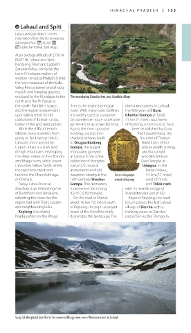
enclosed by the Himalayas to the The meandering Chandra river, near Gondhla village
north and the Pir Panjal to
the south. Rainfall is scarce, river, is the region’s principal oldest monastery in Lahaul,
and the region is dependent town. With many basic facilities, the 800-year-old Guru
upon glacial melt for the it is widely used as a stopover Ghantal Gompa at Tandi,
cultivation of its main crops, by travellers en route to Leh (see 11 km (7 miles) southwest
barley, millet and seed potato. pp140–41) or as a base for treks. of Keylong, is believed to have
While the difficult terrain Across the river, opposite been etablished by Guru
inhibits many travellers from Keylong, a steep tree- Padmasambhava, the
going to Spiti (see pp134–5), shaded pathway leads founder of Tibetan
Lahaul is more accessible. to Drugpa Kardang Buddhism. Other
Upper Lahaul is a stark land Gompa, the largest places worth visiting
of high mountains enveloping monastery (gompa) are the carved
the deep valleys of the Chandra in Lahaul. It has a fine wooden Mrikula
and Bhaga rivers, while Lower collection of thangkas Devi Temple at
Lahaul lies below Tandi, where (see p127), musical Udaipur, in the
the two rivers meet and instruments and old Pattan Valley,
become the Chandrabhaga, weapons. Nearby is the Detail of a prayer 44 km (27 miles)
or Chenab. 16th-century Shashur wheel at Keylong west of Tandi,
Today, Lahaul’s social Gompa. This monastery and Trilokinath,
structure is an interesting mix is renowned for its long with its marble image of
of Buddhism and Hinduism, 4.5 m (15 ft) thangka. Avalokitesvara (see p145).
reflecting the close ties the On the road to Manali, Beyond Keylong, the road
region had with Tibet, Ladakh about 16 km (10 miles) south to Leh passes the last Lahaul
and neighbouring Kullu. of Keylong, the eight-storeyed village of Darcha with a
Keylong, the district tower of the Gondhla chiefs trekking route to Zanskar
headquarters on the Bhaga dominates the landscape. The (see p156) via the Shingo-la.
Suraj Tal, the glacial lake that is the source of Bhaga river, one of the main rivers in Lahaul
132-133_EW_India.indd 133 26/04/17 11:43 am