
Page 499 - 9780077418427.pdf
P. 499
/Users/user-f465/Desktop
tiL12214_ch18_455-476.indd Page 476 9/3/10 6:21 PM user-f465
tiL12214_ch18_455-476.indd Page 476 9/3/10 6:21 PM user-f465 /Users/user-f465/Desktop
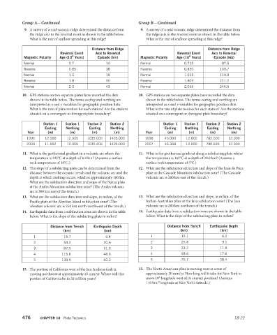
Group A—Continued Group B—Continued
9. A survey of a mid-oceanic ridge determined the distance from 9. A survey of a mid-oceanic ridge determined the distance from
the ridge axis to the reversal event as shown in the table below. the ridge axis to the reversal event as shown in the table below.
What is the rate of seafloor spreading at this ridge? What is the rate of seafloor spreading at this ridge?
Distance from Ridge Distance from Ridge
Reversal Event Axis to Reversal Reversal Event Axis to Reversal
6
6
Magnetic Polarity Age (10 Years) Episode (km) Magnetic Polarity Age (10 Years) Episode (km)
Normal 0.7 14 Normal 0.715 87.5
Reverse 0.85 18 Reverse 0.850 109.7
Normal 1.0 19 Normal 1.015 119.8
Reverse 1.8 35 Reverse 1.805 211.2
Normal 2.0 43 Normal 2.055 246.6
10. GPS stations on two separate plates have recorded the data 10. GPS stations on two separate plates have recorded the data
shown in the table below. The terms easting and northing are shown in the table below. The terms easting and northing are
interpreted as x and y variables for geographic position data. interpreted as x and y variables for geographic position data.
What is the rate of plate motion for each station? Are the stations What is the rate of plate motion for each station? Are the stations
situated on a convergent or divergent plate boundary? situated on a convergent or divergent plate boundary?
Station 1 Station 1 Station 2 Station 2 Station 1 Station 1 Station 2 Station 2
Easting Northing Easting Northing Easting Northing Easting Northing
Year (m) (m) (m) (m) Year (m) (m) (m) (m)
1995 12.000 12.005 1035.000 1405.000 1998 45.000 12.000 782.000 12.000
2009 11.552 12.005 1035.406 1405.000 2007 46.368 12.000 780.695 12.000
11. What is the geothermal gradient in a volcanic arc where the 11. What is the geothermal gradient along a subducting plate where
temperature is 225°C at a depth of 6.0 km? (Assume a surface the temperature is 165°C at a depth of 20.0 km? (Assume a
rock temperature of 10°C.) surface rock temperature of 5°C.)
12. The slope of a subducting plate can be determined from the 12. What are the subduction direction and slope of the Juan de Fuca
distance between the oceanic trench and the volcanic arc and the plate at the Cascade Mountain subduction zone? (The Cascade
depth at which melting occurs, which is approximately 100 km. volcanic arc is 260 km east of the trench.)
What are the subduction direction and slope of the Nazca plate
at the Andes Mountain subduction zone? (The Andes volcanic
arc is 300 km east of the trench.)
13. What are the subduction direction and slope, in m/km, of the 13. What are the subduction direction and slope, in m/km, of the
Pacific plate at the Aleutian Island subduction zone? (The Indian-Australian plate at the Java subduction zone? (The Java
Aleutian volcanic arc is 250 km north-northwest of the trench.) volcanic arc is 280 km northeast of the trench.)
14. Earthquake data from a subduction zone are shown in the table 14. Earthquake data from a subduction zone are shown in the table
below. What is the slope of the subducting plate in m/km? below. What is the slope of the subducting plate in m/km?
Distance from Trench Earthquake Depth Distance from Trench Earthquake Depth
(km) (km) (km) (km)
1 15.7 6.4 1 12.1 4.2
2 54.2 20.6 2 25.4 9.1
3 87.5 31.3 3 33.2 11.8
4 115.6 48.6 4 48.6 17.6
5 139.9 60.2 5 75.7 28.4
15. The portion of California west of the San Andreas fault is 15. The North American plate is moving west at a rate of
moving northwest at approximately 45 mm/yr. Where will this approximately 20 mm/yr. How long will it take for New York to
portion of California be in 20 million years? move 10° longitude west of its current position? (Assume
110 km/°longitude at New York’s latitude.)
476 CHAPTER 18 Plate Tectonics 18-22