
Page 28 - (DK Eyewitness) Travel Guide - Australia
P. 28
26 INTRODUCING A USTR ALIA
Australia’s Landscape
Geological stability has been largely responsible for creating
the landscape of the earth’s oldest, flattest and driest
inhabited continent. Eighty million years ago, Australia’s last
major bout of geological activity pushed up the Great Dividing
Range, but since then the continent has slept. Mountains have
been eroded down, making it difficult for rain clouds to
develop. Deserts have formed in once lush areas and today
more than 70 per cent of the continent is arid. However, with
some of the oldest rocks on earth, its landscapes are anything Australia’s drift towards the
but uniform, and include rainforests, tropical beaches, glacial equator has brought a northern
monsoon climate, as in Kakadu
landforms, striking coastlines and flood plains. National Park (see pp280–81).
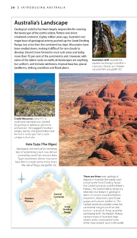
Cradle Mountain (see p471) in
southwest Tasmania was created
by geological upheaval, glaciation
and erosion. Here jagged mountain
ranges, ravines and glacial lakes have
formed a landscape that is quite
unique in Australia.
Kata Tjuta (The Olgas)
Geological remnants of an immense
bed of sedimentary rock now almost
covered by sand from erosion, Kata
Tjuta’s weathered domes may once
have been a single dome many times
the size of Uluru (see pp290–93).
There are three main geological
regions in Australia: the coastal plain
including the Great Dividing Range;
the Central Lowlands; and the Western
Plateau. The Great Dividing Range is a
relatively new feature in geological
Central terms. It contains Australia’s highest
Lowlands
Western mountains, deep rivers, spectacular
Plateau gorges and volcanic landforms. The
Central Lowlands subsided when the
Great continental margins on either side
Dividing rose up – a result of rifting caused by
Range
continental drift. The Western Plateau
contains many of Australia’s large
deserts and is composed of some
of the most ancient rocks in the world.