
Page 171 - (DK Eyewitness) Travel Guide - The Netherlands
P. 171
INTRODUCING THE WESTERN NE THERLANDS 169
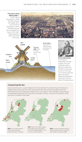
This view is of the
oldest polder in
North Holland
(anonymous, c.1600).
The West Friesland
Omringdijk, which
runs around Het
Grootslag, is 126 km
(78 miles) long and
was completed as far
back as 1250. North
Holland ceased to
exist to the north
of the dyke.
Upper At low tide the
windmill ring canal can
drain the water
The ring pumped out of
dyke stems the polder.
the water
from the ring
Archimedes’ canal.
screw
Seepage In the 16th century,
Middle channel Jan Adriaansz.
reservoir Leeghwater invented
a system that used
windmills to drain a
lake after a ring canal
had been constructed
around it. This meant
that it became relatively
easy to pump dry
deeper and larger lakes,
giving rise to the first
pieces of reclaimed land.
Conquering the Sea
God created the earth – except Holland, for the Dutch did that. This statement by the French poet
Voltaire comes close to the truth. This is because since the 14th century, the surface area of the
Netherlands has increased by approximately 10 per cent, thanks to land reclamation. Land continues
to be extended today, with the construction, for example, of IJburg, a new area of Amsterdam, which
was built on an island in the IJmeer.
1900 Thanks to the steam engine,
1860 Land could be drained increasingly lower-lying polders, 2000 The new Amsterdam district of
only by using windmills. such as the Zuidplaspolder, at -6.74 IJburg is built in the IJmeer using the
Limited areas were reclaimed. m (-22 ft), could be drained. most modern methods available.
168-169_EW_Netherlands.indd 169 16/01/17 11:54 am