
Page 281 - (DK Eyewitness) Travel Guide - The Netherlands
P. 281
THE WEST FRISIAN ISLANDS 279
A horse-drawn lifeboat, the pride of Ameland
in the old centre recall the days Balg, Kobbeduinen and the salt metres in height and an
when many islanders made marshes) in particular make for impressive salt marsh are its
their living from whaling. wonderful walking areas, with characteristic features. The
If you want to see the real their varied flora (including many island also belongs to the
Ameland, you must visit Hollum. orchids) and bird life. No cars at seals and birds.
The Zuiderlaan and Oosterlaan all are allowed on the island.
are steeped in the atmosphere
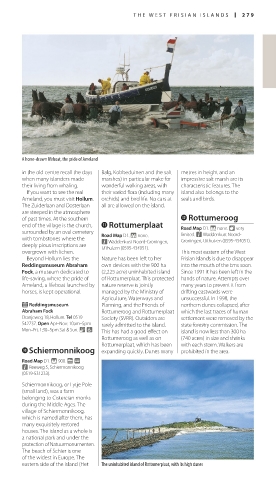
of past times. At the southern w Rottumeroog
end of the village is the church, q Rottumerplaat Road Map D1. * none. 8 very
surrounded by an oval cemetery Road Map D1. * none. limited. n Waddenkust Noord-
with tombstones where the n Waddenkust Noord-Groningen, Groningen, Uithuizen (0595-434051).
deeply pious inscriptions are Uithuizen (0595-434051).
overgrown with lichen. This most eastern of the West
Beyond Hollum lies the Nature has been left to her Frisian Islands is due to disappear
Reddingsmuseum Abraham own devices with the 900 ha into the mouth of the Ems soon.
Fock, a museum dedicated to (2,225 acre) uninhabited island Since 1991 it has been left in the
life-saving, where the pride of of Rottumerplaat. This protected hands of nature. Attempts over
Ameland, a lifeboat launched by nature reserve is jointly many years to prevent it from
horses, is kept operational. managed by the Ministry of drifting eastwards were
Agriculture, Waterways and unsuccessful. In 1998, the
E Reddingsmuseum Planning, and the Friends of northern dunes collapsed, after
Abraham Fock Rottumeroog and Rottumerplaat which the last traces of human
Oranjeweg 18, Hollum. Tel 0519 Society (SVRR). Outsiders are settlement were removed by the
542737. Open Apr–Nov: 10am–5pm rarely admitted to the island. state forestry commission. The
Mon–Fri, 1:30–5pm Sat & Sun. & 7 This has had a good effect on island is now less than 300 ha
Rottumeroog as well as on (740 acres) in size and shrinks
Rottumerplaat, which has been with each storm. Walkers are
0 Schiermonnikoog expanding quickly. Dunes many prohibited in the area.
Road Map D1. * 900. g @
n Reeweg 5, Schiermonnikoog
(0519-531233).
Schiermonnikoog, or Lytje Pole
(small land), was a farm
belonging to Cistercian monks
during the Middle Ages. The
village of Schiermonnikoog,
which is named after them, has
many exquis itely restored
houses. The island as a whole is
a national park and under the
protection of Natuurmonumenten.
The beach of Schier is one
of the widest in Europe. The
eastern side of the island (Het The uninhabited island of Rottumerplaat, with its high dunes
278-279_EW_Netherlands.indd 279 16/01/17 12:05 pm