
Page 101 - (DK) Ocean - The Definitive Visual Guide
P. 101
COASTAL LANDSCAPES 99
INDIAN OCEAN NORTHWEST INDIAN OCEAN NORTHEAST were later thrust upwards and tipped
SATELLITE VIEW over at an angle when India began to
Tigris Euphrates The delta’s seaward edge has Krabi Coast collide with mainland Asia some 50
advanced by about 250km (150 miles) million years ago. Around Krabi and
Delta in the past 3,000 years. TYPE Primary coast Phang Nga Bay to its north, chemical
FORMATION Chemical erosion of these limestone strata by
TYPE Primary coast
erosion of limestone rainwater, followed by sea-level rise,
FORMATION Sediment followed by drowning has created thousands of craggy karst
deposition from Tigris, EXTENT 160km
Euphrates, and Karun hills and islands. These include a
(100 miles) number of isolated cone- and
EXTENT 150 km LOCATION Andaman Sea coast of southwestern
(95 miles) cylinder-shaped karst towers that rise
Thailand out of the sea to heights of up to
LOCATION Parts of southeastern Iraq, northeastern
Kuwait, and southwestern Iran 210m (700ft) and groups of towers
The area around Krabi on the western that sit on broad masses of limestone.
The Tigris Euphrates delta is a broad coast of southern Thailand is notable Many of these karst formations are
area of marshes and alluvial plain for its fantastic-looking formations of elongated in a northeast-southwest
at the northern head of the Arabian partially dissolved limestone, known direction, reflecting the axis (or strike
Gulf, formed from sediment deposited as karst. This limestone was originally line) around which the original layers
by three major rivers. An important formed about 260 million years ago. of limestone were tipped.
wildlife haven, the delta suffered great At that time, a shallow sea covered
ecological damage between the 1970s what is now south Asia and slowly KOH TAPU ISLAND
and 2003 from various drainage and built up deposits of shells and coral Some of the karst formations along this coast
damming schemes carried out for that sediments washed in from the have been weathered into unusual shapes,
military and political purposes. Fisheries land subsequently buried. These as in these examples at Koh Tapu Island in
and several animal species became formed layers of limestone, which Phang Nga Bay to the north of Krabi.
threatened. Some recovery from the
damage has occurred since 2003.
INDIAN OCEAN SOUTHEAST One of Australia’s best-known
geological landmarks is a group of
The Twelve Apostles large sea stacks formed through the
erosion of 20-million-year-old
TYPE Secondary coast limestone cliffs. Known as the Twelve
FORMATION Wave Apostles, even though there were
erosion of cliffs originally only nine of them, the
producing large sea
stacks stacks are up to 70m (230ft) tall.
In 2005, one of the stacks collapsed,
EXTENT 3km (2 miles)
leaving just eight. Collapses such as
LOCATION Near Port Campbell, southwest of this are quite common and are an
Melbourne, Victoria, southeastern Australia
integral part of the erosion process.
ONGOING EROSION
The effects of wave erosion can
clearly be seen at the bases of
the remaining Apostles.
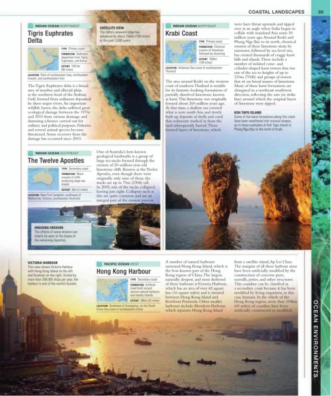
VICTORIA HARBOUR PACIFIC OCEAN WEST A number of natural harbours from a satellite island, Ap Lei Chau.
This view shows Victoria Harbour surround Hong Kong Island, which is The margins of all these harbour areas
with Hong Kong Island on the left Hong Kong Harbour the best-known part of the Hong have been artificially modified by the
and Kowloon on the right. Visited by Kong region of China. The largest, construction of concrete piers,
more than 200,000 ships per year, the TYPE Secondary coast naturally deepest, and most sheltered seawalls, jetties, and other structures.
harbour is one of the world’s busiest. FORMATION Artificial of these harbours is Victoria Harbour, This coastline can be classified as
coast built around which has an area of over 42 square a secondary coast because it has been
various natural harbours km (16 square miles) and is situated modified by living organisms, in this
and nearby islands
between Hong Kong Island and case, humans. In the whole of the
EXTENT 40km (25 miles) Kowloon Peninsula. Other smaller Hong Kong region, more than 100km
LOCATION Southeast of Guangzhou, on the South harbours include Aberdeen Harbour, (60 miles) of coastline have been
China Sea coast of southeastern China which separates Hong Kong Island artificially constructed or modified. OCEAN ENVIRONMENTS