
Page 97 - (DK) Ocean - The Definitive Visual Guide
P. 97
COASTAL LANDSCAPES 95
ATLANTIC OCEAN NORTHWEST HUMAN IMPACT
Hatteras Island CAPE HATTERAS
LIGHTHOUSE
TYPE Secondary coast
FORMATION Deposition
of sediment by waves Erosion and deposition often
and currents cause shorelines to migrate.
EXTENT 70 miles In 1999, the Cape Hatteras
(112 km) Lighthouse was moved
LOCATION Off the coast of North Carolina, because the sea had
northeastern US begun to lap at its
base, threatening
Hatteras Island is a classic barrier its destruction.
island of sandy composition. It runs
parallel to the mainland and is long
and narrow, with an average width of
1,500 ft (450 m), and has been shaped
by complex processes of deposition
effected by ocean currents and waves.
It is part of a series of barrier islands
called the Outer Banks and has two
HATTERAS SHORELINE
distinct sections, which join at a Hatteras Island is a typical barrier island, NEW POSITION
promontory called Cape Hatteras. The being low-lying with wave-straightened The lighthouse is now located about 1,500 ft
dangerously turbulent waters in this shorelines. (450 m) back from the shoreline.
area have resulted in hundreds of
shipwrecks over the centuries.
high. These are the eroded remnants
ATLANTIC OCEAN WEST
of two lava domes (large masses of
Les Pitons lava) that formed some 250,000 years
ago on the flank of a huge volcano.
TYPE Primary coast The volcano later collapsed, leaving
FORMATION Volcanic behind the peaks and other volcanic
lava-dome formation features in the area. The volcanic rocks
followed by volcano on this coast are densely vegetated,
collapse and erosion
except on the very steepest parts of
1
EXTENT 4 / 2 miles (7 km) Les Pitons themselves. Beneath the sea
LOCATION Southwestern coast of St. Lucia, Lesser are some scattered coral reefs within
Antilles, eastern Caribbean a series of protected marine reserves.
This region was declared a World
The southwestern coastline on the Heritage Site in 2004.
Caribbean island of St. Lucia is rocky,
highly indented, and steeply shelving. TWIN PEAKS
A landmark here is Les Pitons (“The In this view, Petit Piton is the nearer peak,
Peaks”), two steep-sided mountain while Gros Piton, which is slightly higher and
spires, each more than 2,430 ft (740 m) much broader, is visible in the background.
ATLANTIC OCEAN NORTHEAST
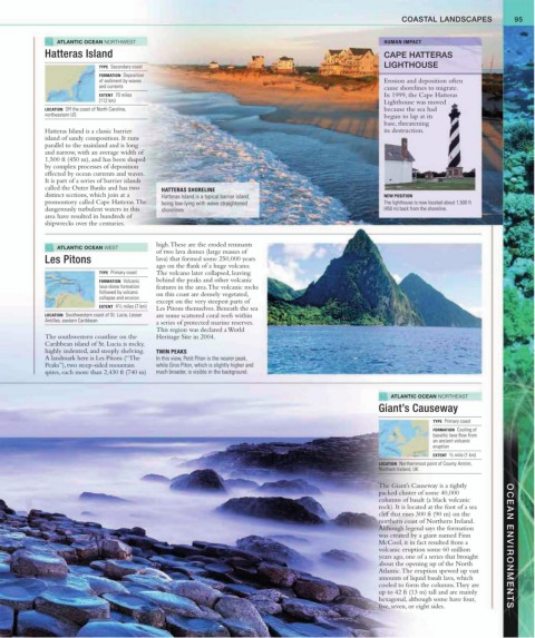
Giant’s Causeway
TYPE Primary coast
FORMATION Cooling of
basaltic lava flow from
an ancient volcanic
eruption
3
EXTENT / 5 mile (1 km)
LOCATION Northernmost point of County Antrim,
Northern Ireland, UK
The Giant’s Causeway is a tightly
packed cluster of some 40,000
columns of basalt (a black volcanic
rock). It is located at the foot of a sea
cliff that rises 300 ft (90 m) on the
northern coast of Northern Ireland.
Although legend says the formation
was created by a giant named Finn
McCool, it in fact resulted from a OCEAN ENVIRONMENTS
volcanic eruption some 60 million
years ago, one of a series that brought
about the opening up of the North
Atlantic. The eruption spewed up vast
amounts of liquid basalt lava, which
cooled to form the columns. They are
up to 42 ft (13 m) tall and are mainly
hexagonal, although some have four,
five, seven, or eight sides.