Page 99 - (DK) Ocean - The Definitive Visual Guide
P. 99

COASTAL LANDSCAPES             97


                                                                                                         ATLANTIC OCEAN NORTHEAST
                                                                                                      Western Algarve

                                                                                                                     TYPE  Secondary coast
                                                                                                                     FORMATION  Erosional
                                                                                                                     action of waves on
                                                                                                                     ancient rock strata
                                                                                                                     EXTENT  84 miles
                                                                                                                     (135 km)
                                                                                                      LOCATION  Southern and southwestern coast
                                                                                                      of Portugal
                                                                                                      The western Algarve coast extends
                                                                                                      from the city of Faro in southern
                                                                                                      Portugal to Cape St. Vincent, at the
                                                                                                      southwestern tip of the Iberian
                                                                                                      Peninsula, and then for a further
                                                                                                      30 miles (50 km) to the north. This
                                                                                                      coastline, which is bathed by the
                                                                                                      warm Gulf Stream, is notable for its
                                                                                                      picturesque, honey-colored limestone
                                                                                                      cliffs, small bays and coves, sheltered
                                                                                                      beaches of fine sand, and emerald-
                                                                                                      green water. Many stretches of this
                                                                                                      coast show typical features of marine
                                                                                                      erosion at work, including caves at
                                                                                                      the feet of cliffs, grottoes, blowholes,
                                                                                                      arches forming through headlands,
                                                                                                      and sea stacks (isolated pillars of rock
                                                                                                      set off from headlands). Although
                                                                          BALANCED STACK              limestone is a primary component of
                                                                          At Marinha Beach near Carvoeiro, wind   the landscape, other rocks, including
                                                                          and waves have produced distinctive rock   sandstones and shales, form parts of
                                                                          formations, such as this eroded sea stack   the cliffs along scattered stretches
                                                                          balanced on the shoreline.  of the coast. The strikingly beautiful
                                                                                                      scenery has made this coast a popular
                                                                                                      vacation destination.


                ATLANTIC OCEAN EAST           ATLANTIC OCEAN EAST
             Amalfi Coast                  Nile Delta
                           TYPE  Secondary coast         TYPE  Primary coast
                           FORMATION  Marine             FORMATION  Deposition
                           erosion of folded and         of sediment at mouth
                           inclined limestone rock       of Nile River
                           strata
                                                         EXTENT  150 miles
                           EXTENT  43 miles (69 km)      (240 km)
             LOCATION  Southern side of the Sorrento Peninsula,   LOCATION  North of Cairo, northern Egypt
             south of Naples, southern Italy
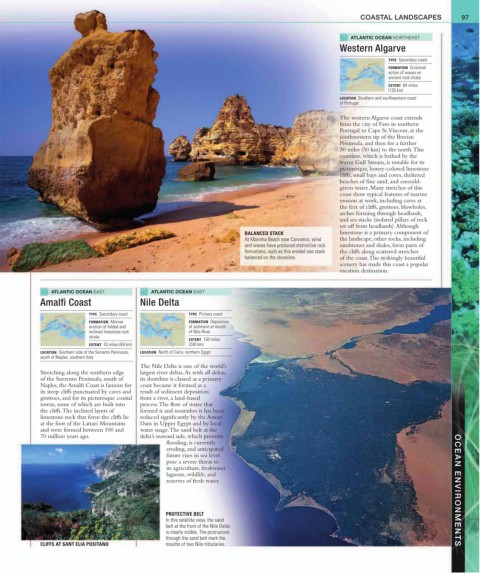
                                           The Nile Delta is one of the world’s
             Stretching along the southern edge    largest river deltas. As with all deltas,
             of the Sorrento Peninsula, south of   its shoreline is classed as a primary
             Naples, the Amalfi Coast is famous for   coast because it formed as a
             its steep cliffs punctuated by caves and   result of sediment deposition
             grottoes, and for its picturesque coastal   from a river, a land-based
             towns, some of which are built into   process. The flow of water that
             the cliffs. The inclined layers of   formed it and nourishes it has been
             limestone rock that form the cliffs lie   reduced significantly by the Aswan
             at the foot of the Lattari Mountains   Dam in Upper Egypt and by local
             and were formed between 100 and    water usage. The sand belt at the
             70 million years ago.         delta’s seaward side, which prevents
                                                  flooding, is currently
                                                  eroding, and anticipated
                                                  future rises in sea level
                                                  pose a severe threat to
                                                  its agriculture, freshwater
                                                  lagoons, wildlife, and
                                                  reserves of fresh water.                                                               OCEAN ENVIRONMENTS


                                                  PROTECTIVE BELT
                                                  In this satellite view, the sand
                                                  belt at the front of the Nile Delta
                                                  is clearly visible. The protrusions
                                                  through the sand belt mark the
             CLIFFS AT SANT ELIA POSITANO         mouths of two Nile tributaries.
   94   95   96   97   98   99   100   101   102   103   104