
Page 104 - (DK) Ocean - The Definitive Visual Guide
P. 104
102 COASTS AND THE SEASHORE
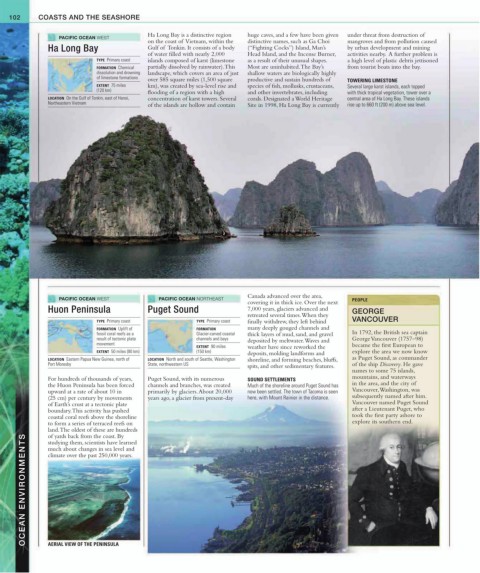
PACIFIC OCEAN WEST Ha Long Bay is a distinctive region huge caves, and a few have been given under threat from destruction of
on the coast of Vietnam, within the distinctive names, such as Ga Choi mangroves and from pollution caused
Ha Long Bay Gulf of Tonkin. It consists of a body (“Fighting Cocks”) Island, Man’s by urban development and mining
of water filled with nearly 2,000 Head Island, and the Incense Burner, activities nearby. A further problem is
TYPE Primary coast islands composed of karst (limestone as a result of their unusual shapes. a high level of plastic debris jettisoned
FORMATION Chemical partially dissolved by rainwater). This Most are uninhabited. The Bay’s from tourist boats into the bay.
dissolution and drowning landscape, which covers an area of just shallow waters are biologically highly
of limestone formations over 585 square miles (1,500 square productive and sustain hundreds of TOWERING LIMESTONE
EXTENT 75 miles km), was created by sea-level rise and species of fish, mollusks, crustaceans, Several large karst islands, each topped
(120 km) flooding of a region with a high and other invertebrates, including with thick tropical vegetation, tower over a
LOCATION On the Gulf of Tonkin, east of Hanoi, concentration of karst towers. Several corals. Designated a World Heritage central area of Ha Long Bay. These islands
Northeastern Vietnam of the islands are hollow and contain Site in 1998, Ha Long Bay is currently rise up to 660 ft (200 m) above sea level.
Canada advanced over the area,
PACIFIC OCEAN WEST PACIFIC OCEAN NORTHEAST PEOPLE
covering it in thick ice. Over the next
Huon Peninsula Puget Sound 7,000 years, glaciers advanced and GEORGE
retreated several times. When they
TYPE Primary coast TYPE Primary coast finally withdrew, they left behind VANCOUVER
FORMATION Uplift of FORMATION many deeply gouged channels and
fossil coral reefs as a Glacier-carved coastal thick layers of mud, sand, and gravel In 1792, the British sea captain
result of tectonic plate channels and bays deposited by meltwater. Waves and George Vancouver (1757–98)
movement
EXTENT 90 miles weather have since reworked the became the first European to
EXTENT 50 miles (80 km) (150 km) deposits, molding landforms and explore the area we now know
LOCATION Eastern Papua New Guinea, north of LOCATION North and south of Seattle, Washington shoreline, and forming beaches, bluffs, as Puget Sound, as commander
Port Moresby State, northwestern US spits, and other sedimentary features. of the ship Discovery. He gave
names to some 75 islands,
For hundreds of thousands of years, Puget Sound, with its numerous SOUND SETTLEMENTS mountains, and waterways
the Huon Peninsula has been forced channels and branches, was created Much of the shoreline around Puget Sound has in the area, and the city of
upward at a rate of about 10 in primarily by glaciers. About 20,000 now been settled. The town of Tacoma is seen Vancouver, Washington, was
(25 cm) per century by movements years ago, a glacier from present-day here, with Mount Rainier in the distance. subsequently named after him.
of Earth’s crust at a tectonic plate Vancouver named Puget Sound
boundary. This activity has pushed after a Lieutenant Puget, who
coastal coral reefs above the shoreline took the first party ashore to
to form a series of terraced reefs on explore its southern end.
land. The oldest of these are hundreds
of yards back from the coast. By
OCEAN ENVIRONMENTS AERIAL VIEW OF THE PENINSULA
studying them, scientists have learned
much about changes in sea level and
climate over the past 250,000 years.