Page 98 - (DK) Ocean - The Definitive Visual Guide
P. 98

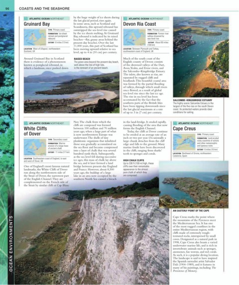
96      COASTS AND THE SEASHORE


                  ATLANTIC OCEAN NORTHEAST   by the huge weight of ice sheets during   ATLANTIC OCEAN NORTHEAST
                                             the last glacial period, rises again.
               Gruinard Bay                  In some areas, such as Scotland and   Devon Ria Coast
                                             Scandinavia, this upward rebound has
                              TYPE  Primary coast  outstripped the sea-level rise caused   TYPE  Primary coast
                              FORMATION  Ice-sheet   by the ice sheets melting. At Gruinard   FORMATION  Former river
                              retreat and postglacial   Bay, rebound is indicated by its raised   valleys drowned by
                              rebound        beaches—flat, grassy areas behind the       sea-level rise
                              EXTENT  8 miles (13 km)   present-day beaches. Over the last    EXTENT  About 60 miles
                                             11,000 years, this part of Scotland has     (100 km)
               LOCATION  West of Ullapool, northwestern    been moving upward relative to sea   LOCATION  Between Plymouth and Torbay,
               Scotland, UK                  level, up to 4 in (10 cm) per century.  southwestern coast of England, UK
               Around Gruinard Bay in Scotland   RAISED BEACH              Much of the south coast of the
               there is evidence of a phenomenon   The green area beyond the present-day beach,   English county of Devon consists
               known as postglacial rebound, in   well above the line of high tide,    of the drowned valleys of the Dart,
               which a landmass, once pushed down   is the remnant of an ancient beach.  Avon, Yealm, and Erme rivers, and
                                                                           the Salcombe–Kingsbridge Estuary.
                                                                           The inlets, also known as rias, are
                                                                           separated by rugged cliffs and
                                                                           headlands. This beautiful coastal area
                                                                           was formed by the partial flooding
                                                                           of valleys, through which small rivers
                                                                           once flowed, as a result of global
                                                                           sea-level rise since the last ice age.
                                                                           The rise in sea level has been
                                                                           accentuated by the fact that the  SALCOMBE–KINGSBRIDGE ESTUARY
                                                                           southern parts of the British Isles  The highly scenic Salcombe Estuary is the
                                                                           have been tipping downwards since  largest of the five rias on the south Devon
                                                                           the last glacial maximum at a rate  coast. Its protected waters provide ideal
                                                                           of up to 3 in (7 cm) per century.  conditions for sailing.

                                             Nez. The chalk from which the    in the land-bridge. It eroded rapidly,
                  ATLANTIC OCEAN NORTHEAST                                                                  ATLANTIC OCEAN NORTHEAST
                                             cliffs are composed was formed   causing flooding of the area that now
               White Cliffs                  between 100 million and 70 million   forms the English Channel.   Cape Creus
                                             years ago, when a large part of what    Today, the cliffs at Dover continue
               of Dover                      is now northwestern Europe was   to be eroded at an average rate of an    TYPE  Primary coast
                                             underwater. The shells of tiny   inch or two per year. Occasionally a     FORMATION  Land-eroded
                              TYPE  Secondary coast
                                             planktonic organisms that inhabited   large chunk detaches from the cliff   rocky coastline of schists
                              FORMATION  Marine   those seas gradually accumulated on   edge and falls to the ground. Many   and other metamorphic
                              erosion of a large mass                                                                  and igneous rocks
                              of ancient chalk   the sea floor and became compressed   marine fossils have been discovered
                                             into a layer of chalk that was several   in the cliffs, ranging from sharks’    EXTENT  6 miles (10 km)
                              EXTENT  11 miles (17 km)
                                             hundred yards thick. Subsequently,    teeth to sponges and corals.  LOCATION  Northeast of Girona, northeastern
                                             as the sea level fell during successive                    Catalonia, Spain
               LOCATION  Southeastern coast of England, to east
               and west of Dover, UK         ice ages, this mass of chalk lay above   HIGH CHALK CLIFFS
                                             the sea, and it later formed a land   Up to 330 ft (100 m) high, these
               One of England’s most famous natural   bridge between present-day England   cliffs owe their remarkable
               landmarks, the White Cliffs of Dover   and France. However, about 8,500   appearance to the almost
               run along the northwestern side of    years ago, the buildup of a large    pure chalk of which they
               the Strait of Dover, the narrowest part   lake in an area now occupied by the   are composed.
               of the English Channel. They are   southern North Sea caused a breach
               complemented on the French side of
               the Strait by similar cliffs at Cap Blanc


                                                                                                        AN EASTERLY POINT OF THE CAPE

                                                                                                        Cape Creus marks the point where
        OCEAN ENVIRONMENTS                                                                              entire Mediterranean region, with
                                                                                                        the mountains of the Pyrenees meet
                                                                                                        the Mediterranean Sea. It has one
                                                                                                        of the most rugged coastlines in the
                                                                                                        cliffs made of extremely rough-
                                                                                                        textured rocks, interspersed by small
                                                                                                        coves. Designated as a natural park in
                                                                                                        1998, Cape Creus also boasts a varied
                                                                                                        underwater marine life, and is rich in
                                                                                                        invertebrate animals such as sponges,
                                                                                                        anemones, fan worms, and red corals.
                                                                                                        As such, it is a popular diving location.
                                                                                                        The landscape is said to have inspired
                                                                                                        the Spanish surrealist artist Salvador
                                                                                                        Dali (1904–1989), and it features in
                                                                                                        many of his paintings, including The
                                                                                                        Persistence of Memory.
   93   94   95   96   97   98   99   100   101   102   103