
Page 445 - (DK) Ocean - The Definitive Visual Guide
P. 445
THE CENTRAL ATLANTIC 443
triple-junction. Two of the rifts but to attempt the arduous journey
ATLANTIC OCEAN I1 ATLANTIC OCEAN K4
continued opening to the south out of the Namib Desert on foot.
Gulf of Guinea and the west, forming today’s south Skeleton Coast Namibia’s coastal waters are dredged
Atlantic Ocean. Activity in the third for diamonds, as the Benguela
AREA 500,000 square miles (1.4 million square km) rift, to the northeast, ceased rather TYPE Secondary coast Current carries sediments from the
MAXIMUM DEPTH 17,070 ft (5,204 m) quickly. The site of this stalled spreading LENGTH 870 miles (1,400 km) Orange River north along the coast.
centre is marked by a chain of extinct These sediments include large
INFLOWS Atlantic Ocean, Niger, Volta rivers
volcanoes, including the islands of The cold Benguela Current hugs quantities of gem-quality diamonds
Part of the north Atlantic’s Canaries Annabon, São Tomé, Principe, and the west coast of southern Africa washed down from the South African
Current continues along the African Bioco in the Gulf of Guinea, and and dominates its climate. Although interior. A rich fishery is another
coast and into the Gulf of Guinea as Mount Cameroon inland. São Tomé prevailing winds are from the sea, the by-product of the
the eastward-flowing Guinea Current. rises 6,640 ft (2,020 m) above sea level. air above the cold water carries little Benguela Current,
The main freshwater input to the gulf moisture, and the adjacent coast is a which causes
is provided by the River Niger, which desert. When warm air from the land upwelling of
has an extensive depositional fan, up meets the cold sea air, dense fogs nutrient-rich
to 2.5 miles (4km) thick. An even often form. This can be a hazard waters.
greater source of fresh water for the to navigation, as testified to by
south Atlantic is from the Congo the numerous ship hulks along the
River to the south. Large oil and notorious Skeleton Coast. Even
gas reserves have accumulated in without the fog, any vessel disabled
the sediments of the Niger Delta and by engine trouble is driven towards
Fan, and Nigeria is Africa’s biggest oil the shore by wind and current, and
producer. Smaller deposits lie in the the nearest ports are quite distant.
Congo Fan and in the continental Many sailors who have survived being
shelf off Gabon, and deeper water shipwrecked here have had little choice
in the Gulf of Guinea is now being
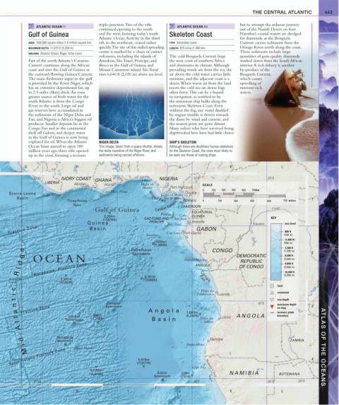
explored for oil. When the Atlantic NIGER DELTA SHIP’S SKELETON
Ocean basin started to open 180 This image, taken from a space shuttle, shows Although there are doubtless human skeletons
million years ago, three rifts opened the delta coastline of the Niger River, and on the Skeleton Coast, the ones most likely to
up in the crust, forming a tectonic sediments being carried offshore. be seen are those of rusting ships.
G H I J K L
10˚W IVORY COAST 0˚ Volta Lagos NIGERIA 10˚E 20˚E
LIBERIA Abidjan GHANA Bight of SCALE
Accra
Benin Niger Port Harcourt
Cape Three Points 0 150 300 450 600 750km
Sierra Leone Cape Palmas Niger Fan Douala
Bight of Biafra
Basin Isla de Bioco 1
Three Points Malabo 0 150 300 450 600 750 miles
Spur Calabar Canyon CAMEROON
Gulf of Guinea Congo
Príncipe EQUATORIAL
5,204m Cabo GUINEA KEY
(17,074ft) SAO TOME AND San Juan
Guinea PRINCIPE São Tomé Libreville Equator sea level
Fracture Zone Basin Annobón Cap Lopez Port-Gentil (250 m)
GABON
800 ft
600m Congo (1,600 ft)
(1,969ft) (500 m)
3,300 ft
e Pierre Brazza CONGO (1,000 m)
Seamounts 6,500 ft 2
g
OCEAN Pointe-Noire DEMOCRATIC (2,000 m)
d ANGOLA REPUBLIC 9,800 ft
i Ascension Fracture Zone OF CONGO (3,000 m)
R (5,000 m)
16,400 ft
5,391m
Ascension 3,332m (17,688ft) Fan
Congo
Island (10,932ft)
land
c Ponta das
i Palmeirinhas Luanda seamount
t sea depth
Dampier 10˚S
n Seamount maximum depth 3
on map
a l Fracture Zone Angola 1,600m tectonic plate
Cardno 384m (5,250ft) Ponta das Lobito ANGOLA boundary
Tablemount (1,260ft) Basin
t Salinas
A
-
Bonaparte
d Seamount Namibe ZAMBIA
Ponta Albina
i Saint Helena ATLAS OF THE OCEANS
Saint Helena Fracture Zone 5,479m 4
M
(17,977ft)
Cape Fria Skeleton Coast
6,039m
(19,814ft) Zubov 229m NAMIBIA BOTSWANA
Seamount (751ft)
10˚W 0˚ 10˚E 20˚E 20˚S
G H I J K L