
Page 470 - (DK) Ocean - The Definitive Visual Guide
P. 470
468 THE PACIFIC OCEAN
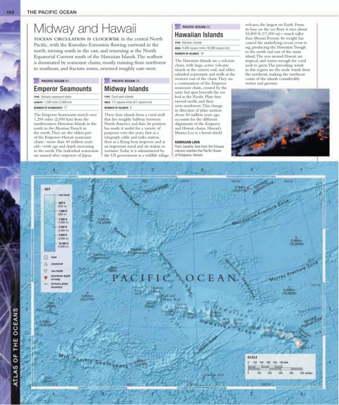
Midway and Hawaii PACIFIC OCEAN E3 volcano, the largest on Earth. From
its base on the sea floor it rises about
Hawaiian Islands 55,800 ft (17,000 m)—much taller
TOCEAN CIRCULATION IS CLOCKWISE in the central North than Mount Everest. Its weight has
TYPE Volcanic islands caused the underlying ocean crust to
Pacific, with the Kuroshio Extension flowing eastward in the
AREA 6,400 square miles (16,600 square km) sag, producing the Hawaiian Trough
north, turning south in the east, and returning as the North to the north and east of the main
NUMBER OF ISLANDS 19
Equatorial Current south of the Hawaiian Islands. The seafloor island. The seas around Hawaii are
is dominated by seamount chains, mostly running from northwest The Hawaiian Islands are a volcanic tropical, and warm enough for coral
chain, with large, active volcanic reefs to grow. The prevailing winds
to southeast, and fracture zones, oriented roughly east–west. islands at the eastern end, and older, in this region are the trade winds from
subsided seamounts and atolls at the the northeast, making the northeast
western end of the chain. They are coasts of the islands considerably
PACIFIC OCEAN B1 PACIFIC OCEAN C3
a continuation of the Emperor wetter and greener.
Emperor Seamounts Midway Islands seamount chain, created by the
same hot spot beneath the sea
TYPE Volcanic seamount chain TYPE Coral atoll islands bed as the Pacific Plate first
LENGTH 1,200 miles (2,000 km) AREA 2 / 2 square miles (6.2 square km) moved north, and then
1
west-northwest. This change
NUMBER OF SEAMOUNTS 17 NUMBER OF ISLANDS 4
in direction of plate motion
The Emperor Seamounts stretch over These four islands form a coral atoll about 40 million years ago
1,200 miles (2,000 km) from the that lies roughly halfway between accounts for the different
northwestern Hawaiian Islands in the North America and Asia. Its position alignments of the Emperor
south to the Aleutian Trench in has made it useful for a variety of and Hawaii chains. Hawaii’s
the north. They are the oldest part purposes over the years, first as a Mauna Loa is a broad shield
of the Emperor–Hawaii seamount telegraph cable and radio station,
chain—more than 40 million years then as a flying boat stopover, and as HAWAIIAN LAVA
old—with age and depth increasing an important naval and air station in Fluid, basaltic lava from the Kilauea
to the north. The individual seamounts wartime. Today it is administered by volcano reaches the Pacific Ocean
are named after emperors of Japan. the US government as a wildlife refuge. at Kalapana, Hawaii.
A B C D E F
170˚E 180˚ 170˚W 160˚W Surveyor 150˚W 40˚N
7,184m
KEY Chinook Trough (23,571ft) Fracture Zone
sea level Emperor Trough
40˚N
1 800 ft Emperor Seamounts 1
(250 m)
1,600 ft Mendocino Fracture Zone
(500 m)
3,300 ft 5,547m
(1,000 m) (18,200ft)
6,500 ft
(2,000 m) Hess Rise
9,800 ft
(3,000 m)
5,999m
16,400 ft (19,683ft)
(5,000 m)
Mellish
Seamount
2 Kammu 2
land Seamount 30˚N
seamount
18m
30˚N
sea depth (59ft) Murray Fracture Zone
maximum depth Northwest Hawaiian Ridge
on map P A CIFIC OCEAN
tectonic plate 150˚W
boundary Midway
Kure Islands 5,999m
Atoll (19,683ft)
5,800m Pearl and
Musicians Seamounts
(22,311ft) Hermes Reef
73m 56m Laysan
(240ft) (184ft) Lisianski Island Moro Pinnacles Island Necker Tropic of Cancer 3
3
ATLAS OF THE OCEANS 4 20˚N M i d - P a c i f i c S e a m o u n t s (2,736ft) Necker Ridge SCALE Kaua‘i O‘ahu Moloka‘i Trough 20˚N 4
Gardner
Tropic of Cancer
Island
Molokai
Reef
Fracture Zone
Tern
6,798m
Island
H a w a i i a n I s l a n d s
(19,023ft)
Nihoa
H a w a i i a n R i d g e
Honolulu
Hawaiian
Maui
Lana‘i
Hilo
Hawai‘i
834m
0
100 200 300 400 500 km
200
Wake
Island
170˚E
A B 180˚ C 170˚W D Johnston Atoll 0 E 100 160˚W 300 400 500 miles
F