Page 471 - (DK) Ocean - The Definitive Visual Guide
P. 471

A                    B                   C                    D                    E                    F                469

                             140˚W             130˚W                 120˚W                 110˚W                   100˚W
                                                               Eureka
                                                                                                  SCALE
                        Mendocino Fracture Zone
                                                          Delgada    Sacramento                   0  100 200 300 400 500 km
                                                            Fan
    1                                                                                         Colorado  0  100  200  300  400  500  miles  1
                            Pioneer Fracture Zone
                                                          San Francisco
                        5,561m
                       (18,246ft)
                                                               Monterey
                                                              Monterey                              UNITED STATES
                                                                Fan
                                                                                                             OF
                                                                                                        AMERICA
                     Murray Fracture Zone                       Channel Islands
                                                                           Los Angeles
                                           Erben                                                                               30˚N
        30˚N
                                       Tablemount      Fieberling         San Diego
                                                       Tablemount      Patton Escarpment  Tijuana
    2                 Moonless Mountains                                                                                             2
                                   1,468m
                                   (4,817ft)
                                                                      Isla Guadalupe  Cedros       Guaymas
                                                                                     Isla
                                          PA CIFIC                                  Punta  B a j a   C a l i f o r n i a
                                                                                   Eugenia     Gulf of California  MEXICO
                                                                516m
                                                               (1,693ft)                                                Tropic of Cancer
        Tropic of Cancer
                                            OCEAN                                        Cedros  Trench            Mazatlán
                Molokai Fracture Zone                                                            La Paz
    3                                                                                               Cabo                             3
                                                                                                  San Lucas
                                                                                                                       Puerto
        20˚N                                                                                                                   20˚N
                                                                                                                       Vallarta
                                                                                                   28m
                                                                                                   (92ft)
                                                                                           Revillagigedo Islands  Rivera Fracture Zone  Middle
                                                                              Alphecca
                                    Clarion Fracture Zone                    Seamount    Clarion                           America
                                                                                                                           Trench
                                                                                         Island
                                                                             Shimada              Mathematicians   Orozco Fracture
                                                                            Seamount                Seamounts
    4                                                                                                              Zone Pacif        4
                            457m                                                                                 Seamount  East
                           (1,499ft)                                                                             Khayyam ic Rise
            140˚W                      130˚W                           120˚W                            110˚W

                 A                    B                   C                    D                    E                    F


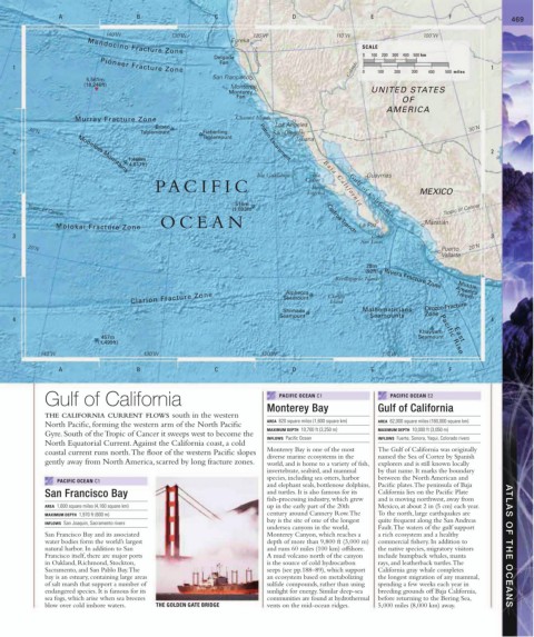
             Gulf of California                                             PACIFIC OCEAN C1             PACIFIC OCEAN E2
                                                                        Monterey Bay                  Gulf of California
             THE CALIFORNIA CURRENT FLOWS south in the western
                                                                        AREA  620 square miles (1,600 square km)  AREA  62,000 square miles (160,000 square km)
             North Pacific, forming the western arm of the North Pacific
                                                                        MAXIMUM DEPTH  10,700 ft (3,250 m)  MAXIMUM DEPTH  10,000 ft (3,050 m)
             Gyre. South of the Tropic of Cancer it sweeps west to become the
                                                                        INFLOWS  Pacific Ocean         INFLOWS  Fuerte, Sonora, Yaqui, Colorado rivers
             North Equatorial Current. Against the California coast, a cold
             coastal current runs north. The floor of the western Pacific slopes   Monterey Bay is one of the most   The Gulf of California was originally
                                                                        diverse marine ecosystems in the   named the Sea of Cortez by Spanish
             gently away from North America, scarred by long fracture zones.  world, and is home to a variety of fish,   explorers and is still known locally
                                                                        invertebrate, seabird, and mammal   by that name. It marks the boundary
                                                                        species, including sea otters, harbor   between the North American and
                PACIFIC OCEAN C1
                                                                        and elephant seals, bottlenose dolphins,  Pacific plates. The peninsula of Baja
             San Francisco Bay                                          and turtles. It is also famous for its   California lies on the Pacific Plate
                                                                        fish-processing industry, which grew   and is moving northwest, away from
             AREA  1,600 square miles (4,160 square km)                 up in the early part of the 20th   Mexico, at about 2 in (5 cm) each year.
             MAXIMUM DEPTH  1,970 ft (600 m)                            century around Cannery Row. The   To the north, large earthquakes are
                                                                        bay is the site of one of the longest   quite frequent along the San Andreas
             INFLOWS  San Joaquin, Sacramento rivers
                                                                        undersea canyons in the world,   Fault. The waters of the gulf support
             San Francisco Bay and its associated                       Monterey Canyon, which reaches a   a rich ecosystem and a healthy
             water bodies form the world’s largest                      depth of more than 9,800 ft (3,000 m)   commercial fishery. In addition to
             natural harbor. In addition to San                         and runs 60 miles (100 km) offshore.    the native species, migratory visitors   ATLAS OF THE OCEANS
             Francisco itself, there are major ports                    A mud volcano north of the canyon    include humpback whales, manta
             in Oakland, Richmond, Stockton,                            is the source of cold hydrocarbon   rays, and leatherback turtles. The
             Sacramento, and San Pablo Bay. The                         seeps (see pp.188–89), which support   California gray whale completes
             bay is an estuary, containing large areas                  an ecosystem based on metabolizing   the longest migration of any mammal,
             of salt marsh that support a number of                     sulfide compounds, rather than using   spending a few weeks each year in
             endangered species. It is famous for its                   sunlight for energy. Similar deep-sea   breeding grounds off Baja California,
             sea fogs, which arise when sea breezes                     communities are found at hydrothermal  before returning to the Bering Sea,
             blow over cold inshore waters.  THE GOLDEN GATE BRIDGE     vents on the mid-ocean ridges.  5,000 miles (8,000 km) away.
   466   467   468   469   470   471   472   473   474   475   476