
Page 487 - (DK) Ocean - The Definitive Visual Guide
P. 487
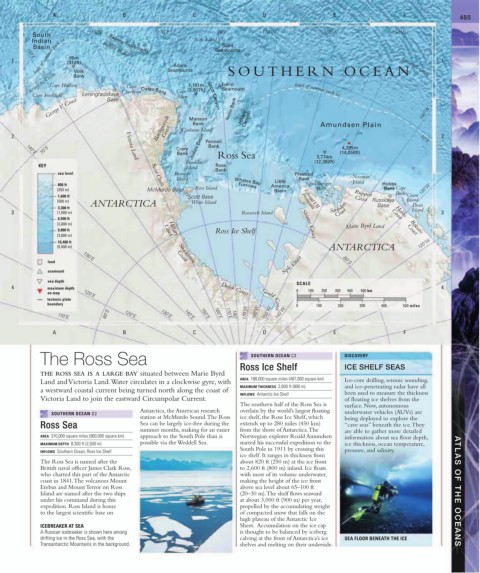
A B C D E F 485
160˚E 170˚E 180˚ 170˚W 160˚W 150˚W
South
limit of summer pack ice 95m
Indian Balleny Seamounts Scott Island
Scott
Basin Balleny Islands Seamounts
150˚E
1 (312ft) Seamounts SOUTHERN OCEAN 1
Adare
Virik
Antarctic Circle Bank Cape 1,191m Iselin
Antarctic Circle
Cape Hudson
Seamount
Cape Freshfield Leningradskaya Cheetham Oates Bank Cape (3,907ft) Scott Canyon limit of summer pack ice
Adare
Base
George V Coast Iselin Bank Hillary 140˚W
Borchgrevink Coast Coulman Island Canyon Amundsen Plain
Manson
Bank
2 Pennell 70˚S 2
70˚S Victoria Land Crary Jodies Basin Bank Ross Sea (14,058ft)
4,285m
Bank
140˚E
3,774m
Franklin (12,382ft)
KEY Island Ross
sea level Scott Coast Beaufort Bank Prestrud
Island Bank Newman
Little Island
Whales Bay
800 ft Furrows America Sulzberger Hobbs
(250 m) McMurdo Base Ross Island Basin Bay Bank Cape 130˚W
Ruppert Burks
1,600 ft Scott Base Edward VII Grant
(500 m) ANTARCTICA White Island Peninsula Coast Russkaya Island
Dean
3,300 ft Saunders Base Island
3 (1,000 m) Roosevelt Island Coast Coast 3
Hobbs
6,500 ft
(2,000 m) Shirase Coast Bakutis
9,800 ft Coast Ross Ice Shelf Marie Byrd Land Coast
(3,000 m)
Hillary
16,400 ft 120˚W
(5,000 m) Shackleton ANTARCTICA
Siple Coast
land 130˚E Coast 80˚S
seamount
sea depth
SCALE
4 maximum depth Dufek Coast 0 100 200 300 400 500 km 4
on map 120˚E
tectonic plate Gould Coast
boundary 0 100 200 300 400 500 miles
80˚S 120˚E 130˚E 140˚E 150˚E 160˚E 170˚E 180˚ 170˚W 160˚W 150˚W 140˚W
110˚E
A B C D E F
The Ross Sea SOUTHERN OCEAN C3 DISCOVERY
Ross Ice Shelf ICE SHELF SEAS
THE ROSS SEA IS A LARGE BAY situated between Marie Byrd
AREA 188,000 square miles (487,000 square km)
Land and Victoria Land. Water circulates in a clockwise gyre, with Ice-core drilling, seismic sounding,
MAXIMUM THICKNESS 2,600 ft (800 m) and ice-penetrating radar have all
a westward coastal current being turned north along the coast of
INFLOWS Antarctic Ice Shelf been used to measure the thickness
Victoria Land to join the eastward Circumpolar Current. of floating ice shelves from the
The southern half of the Ross Sea is surface. Now, autonomous
Antarctica, the American research overlain by the world’s largest floating underwater vehicles (AUVs) are
SOUTHERN OCEAN D2
station at McMurdo Sound. The Ross ice shelf, the Ross Ice Shelf, which being deployed to explore the
Ross Sea Sea can be largely ice-free during the extends up to 280 miles (450 km) “cave seas” beneath the ice. They
summer months, making for an easier from the shore of Antarctica. The are able to gather more detailed
AREA 370,000 square miles (960,000 square km) approach to the South Pole than is Norwegian explorer Roald Amundsen information about sea floor depth,
MAXIMUM DEPTH 8,300 ft (2,500 m) possible via the Weddell Sea. started his successful expedition to the ice thickness, ocean temperature,
South Pole in 1911 by crossing this
INFLOWS Southern Ocean, Ross Ice Shelf pressure, and salinity.
ice shelf. It ranges in thickness from
The Ross Sea is named after the about 820 ft (250 m) at the ice front
British naval officer James Clark Ross, to 2,600 ft (800 m) inland. Ice floats
who charted this part of the Antarctic with most of its volume underwater,
coast in 1841. The volcanoes Mount making the height of the ice front
Erebus and Mount Terror on Ross above sea level about 65–100 ft
Island are named after the two ships (20–30 m). The shelf flows seaward ATLAS OF THE OCEANS
under his command during this at about 3,000 ft (900 m) per year,
expedition. Ross Island is home propelled by the accumulating weight
to the largest scientific base on of compacted snow that falls on the
high plateau of the Antarctic Ice
ICEBREAKER AT SEA Sheet. Accumulation on the ice cap
A Russian icebreaker is shown here among is thought to be balanced by iceberg
drifting ice in the Ross Sea, with the calving at the front of Antarctica’s ice SEA FLOOR BENEATH THE ICE
Transantarctic Mountains in the background. shelves and melting on their underside.