
Page 486 - (DK) Ocean - The Definitive Visual Guide
P. 486
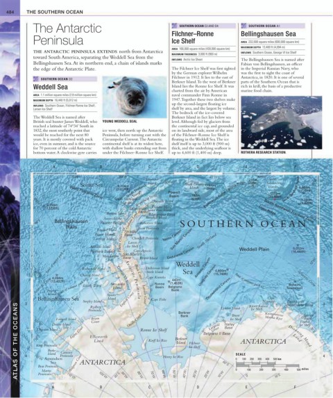
484 THE SOUTHERN OCEAN
The Antarctic SOUTHERN OCEAN C3 AND D4 SOUTHERN OCEAN A1
Filchner–Ronne Bellingshausen Sea
Peninsula Ice Shelf AREA 232,000 square miles (600,000 square km)
MAXIMUM DEPTH 13,400 ft (4,094 m)
AREA 166,000 square miles (430,000 square km)
THE ANTARCTIC PENINSULA EXTENDS north from Antarctica INFLOWS Southern Ocean, George VI Ice Shelf
MAXIMUM THICKNESS 3,000 ft (900 m)
toward South America, separating the Weddell Sea from the
INFLOWS Arctic Ice Sheet The Bellingshausen Sea is named after
Bellingshausen Sea. At its northern end, a chain of islands marks Fabian von Bellingshausen, an officer
the edge of the Antarctic Plate. The Filchner Ice Shelf was first sighted in the Imperial Russian Navy, who
by the German explorer Wilhelm was the first to sight the coast of
Filchner in 1912. It lies to the east of Antarctica, in 1820. It is one of several
SOUTHERN OCEAN D2
Berkner Island. To the west of Berkner parts of the Southern Ocean that is
Weddell Sea Island lies the Ronne Ice Shelf. It was rich in krill, the basis of a productive
charted from the air by American marine food chain.
AREA 1.1 million square miles (2.8 million square km) naval commander Finn Ronne in
MAXIMUM DEPTH 16,440 ft (5,012 m) 1947. Together these two shelves make
up the second-largest floating ice
INFLOWS Southern Ocean, Filchner-Ronne Ice Shelf,
Larsen Ice Shelf shelf by area, and the largest by volume.
The bedrock of the ice-covered
The Weddell Sea is named after Berkner Island in fact lies below sea
British seal hunter James Weddell, who YOUNG WEDDELL SEAL level. Although fed by glaciers from
reached a latitude of 74°34’ South in the continental ice cap, and grounded
1832, the most southerly point that ice west, then north up the Antarctic on its landward side, most of the area
would be reached for the next 80 Peninsula, before turning east with the of the Filchner–Ronne Ice Shelf is
years. It is mostly covered with pack Circumpolar Current. The Antarctic floating in the Weddell Sea. The ice
ice, even in summer, and is the source continental shelf is at its widest here, shelf itself is up to 3,000 ft (900 m)
for 70 percent of the cold Antarctic with shallow banks extending out from thick, and the underlying seafloor is
bottom water. A clockwise gyre carries under the Filchner–Ronne Ice Shelf. up to 4,600 ft (1,400 m) deep. ROTHERA RESEARCH STATION.
A B C D E F
70˚W 60˚W 40˚W 30˚W
Elephant 210m South
Scotia Sea 5,204m Island 50˚W South Orkney Orkney Bruce Ridge (689ft) Sandwich 20˚W
South Shetland
Islands
5,404m
(17,074ft) Powell Islands Deep 7,152m South Sandwich Trench (17,731ft)
T rough
187m
Hero Fracture Zone
1 South Shetland Bransfield Strait Basin (614ft) Endurance Ridge (23,466ft) 1,780m 1
Islands Joinville Island (5,840ft)
80˚W
5,259m
Dundee Island
(17,255ft) Esperanza James Ross Island Ligeti Ridge
Brabant Island Marambio Base South Sandwich Fracture Zone
Anvers Island Graham LandBase Snowhill Island 60˚S
60˚S Bellingshausen Palmer Base Robertson Island SOUTHERN OCEAN
Plain Jason Peninsula
Renaud Island Faraday
Biscoe Islands Base Yelcho Canyon
Churchill Peninsula
Lavoisier Island Larsen San Martin Canyon South Shetland
Adelaide Island Loubet Coast Ice Shelf 5,012m
limit of winter pack ice Bay Base Hearst Island Weddell 10˚W
2 Rothera Base San Martín Endurance Canyon Weddell Plain (16,444ft) 2
Cape Agassiz
Marguerite
Antartic Canyon
Dollerman Island
Rothschild Island
4,800m
Charcot Island George VI Sound Black Coast Steele Island 443m Sea Uruguay Canyon (15,749ft) limit of summer pack ice Antarctic Circle
90˚W
Cape Knowles
Antarctic Circle 4,094m Latady Island Alexander Ronne Belgrano Deutschland Canyon Seamount
Island limit of summer pack ice
(13,432ft)
(1,453ft)
Behaim
Basin
Island
Bank
Peter I
Antarctic Penins
Bellingshausen Sea Spaatz Lassiter Coast Cape Fiske Cape
Island
Smyley Island English Coast ula Berkner Lyddan Island Riiser–Larsen Georg von Sanae 0˚ 3
Norvegia
ATLAS OF THE OCEANS 4 100˚W Burke Peninsula ANTARCTICA Ronne Ice Shelf Berkner Ice Shelf Belgrano II Base SCALE 200 300 400 500 km Dronning Maud 70˚S 4
3
Neumayer Base
Rydberg
Ice Shelf
Peninsula
Brunt
Orville Coast
Kronprinsesse
Bank
Base
Bryan
Martha Kyst
Ice Shelf
Farewell Island
Fimbul
Coast
Halley
Luitpold
Dustin Island
Ice Shelf
Eights Coast
Base
Coast
Thurston Island
70˚S
Ellsworth
Korff Ice Rise
ANTARCTICA
Land
Land
Island Filchner
King Peninsula
Canisteo
Island
Walgreen Coast
Henry Ice Rise
110˚W Amundsen
100
0
Sea
80˚S
Bear Peninsula
Martin
Peninsula
B
A 110˚W 100˚W 80˚S 90˚W 80˚W C 70˚W 60˚W 50˚W 40˚W 30˚W D 20˚W 10˚W 0 E 0˚ 100 200 300 10˚E 400 F 500 miles