
Page 485 - (DK) Ocean - The Definitive Visual Guide
P. 485
D E F G West Australia Current
Benguela 483
Current
60˚E Kerguelen 90˚E
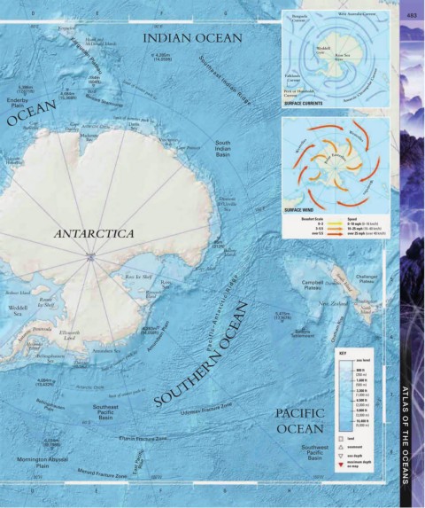
INDIAN OCEAN
Heard and
McDonald Islands
Weddell
Gyre
4,285m Ross Sea
(14,059ft) Gyre
Kerguelen Plateau
Falklands
184m
(604ft) Southeast Indian Ridge Current
5,386m Antarctic Circumpolar Current
(17,671ft) 60˚S limit of winter pack ice Peru or Humboldt
4,684m Current
(15,368ft) Banzare Seamounts SURFACE CURRENTS
Enderby
OCEAN Cape limit of summer pack ice
Plain
Cape
Davis
Antarctic Circle
Batterbee
Darnley
Mackenzie Sea Westerlies
Bay Vincennes
Bay South
Cape Poinsett Indian Westerlies
Basin
Lützow-
Holm Bay Polar Easterlies
Dumont Westerlies
D’Urville
Sea 150˚E SURFACE WIND
Beaufort Scale Speed
0–3 0–10 mph (0–16 km/h)
3–5.5
ANTARCTICA over 5.5 10–25 mph (16–40 km/h)
over 25 mph (over 40 km/h)
95m
(312ft)
Balleny
South Islands
Pole
Cape Adare
Ross Ice Shelf Challenger 5
Ross Campbell Dunedin Plateau
Sea Plateau
South Island
Berkner Island Roosevelt
Island
Ronne Wellington
Ice Shelf New Zealand
Weddell North
Sea P a c i f i c – A n t a r c t i c R i d g e (17,767ft) Island
5,415m
Amundsen Plain
4,283m
Antarctic Peninsula Ellsworth (14,058ft) Tablemount Chatham Rise 180˚ 6
Bollons
Land
Alexander
Island
Amundsen Sea KEY
Bellingshausen SOUTHERN OCEAN
Sea Thurston limit of summer pack ice sea level
Island 800 ft
(250 m)
4,094m 1,600 ft
(13,432ft) (500 m)
Antarctic Circle
limit of winter pack ice (1,000 m) 7
3,300 ft
6,500 ft
Southeast (2,000 m) 30˚S
Bellingshausen
Plain Udintsev Fracture Zone 9,800 ft
Pacific PACIFIC (3,000 m)
Basin
16,400 ft
60˚S (5,000 m)
OCEAN
Eltanin Fracture Zone land ATLAS OF THE OCEANS
6,034m
(19,798ft) Southwest seamount 8
East Pacific Rise maximum depth
Basin
Mornington Abyssal Pacific sea depth
Plain on map
90˚W Menard Fracture Zone 120˚W 150˚W
D E F G H I