
Page 484 - (DK) Ocean - The Definitive Visual Guide
P. 484
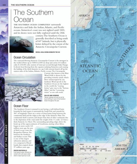
482 THE SOUTHERN OCEAN A B C
Crozet
The Southern 30˚S 30˚E Transkei Escarpment Crozet
Plateau
1 AFRICA Basin Del Cano Islands
Rise
Mozambique
Ocean Elizabeth
Port
Prince
Africana Edward
THE SOUTHERN OCEAN COMPLETELY surrounds Seamount Islands
Cape Agulhas Prince Edward Fracture Zone
Antarctica and links the Indian, Atlantic, and Pacific Town Plateau 5,819m Lena
oceans. Antarctica’s coast was not sighted until 1820, 30˚S Cape of (19,092ft) Seamount
Good Hope
and its shores were not fully explored until the 20th
2
century. The Southern Ocean is
generally described as being south
Cape A t l a n t i c – I n d i a n R i d g e Atlantic–
of 60° latitude, but is physically Basin Indian
better defined by the extent of the Basin
Antarctic Circumpolar Current.
5,115m
WEDELL SEAL DIVING BENEATH THE ICE (16,782ft)
3 Seamounts SOUTHERN
Davis
Ocean Circulation 0˚
The eastward-flowing Antarctic Circumpolar Current is the strongest in Discovery
Seamounts
the world. It flows up to 9,800 ft (3,000 m) deep and carries 4.8 million
cubic ft (135,000 cubic meters) of water per second through Drake Passage. Astrid Ridge
It diverts heat flowing from the equator, isolating Antarctica and causing ATLANTIC
the buildup of the thick Antarctic ice cap. Cold currents branch off up the Maud
Rise
eastern sides of the Indian, Atlantic, Pacific oceans. The Circumpolar 4 OCEAN
Current (also known as the West
Wind Drift) is driven by the Lazarev
Sea
prevailing westerly winds, which America–Antarctica Ridge
blow uninterrupted by any Mid-Atlantic Ridge Cape Norvegia
5,012m
landmass. Wind speeds in the (16,444ft)
Southern Ocean are the highest Gough Fracture Zone
in the world: the “roaring Fracture Zone South Sandwich
forties” give way to the “furious
fifties” and the “screaming 5 Weddell
sixties” as one sails south. Islas Orcadas Ridge Plain
1,748m 7,152m
(5,735ft) (23,466ft)
SEA-ICE AND ICEBERGS South Sandwich Trench
Tabular icebergs and sea ice can be East
found drifting in much of the Southern Scotia
Ocean throughout the year. Basin
Ocean Floor South 187m
30˚W Georgia (604ft)
The Southern Ocean is unusual in not having a well-defined basin 6 South
bounded by land masses: it surrounds the South Pole and extends for 3,667m Orkney
(12,031ft) Islands
360˚ of longitude. There are a series of deep basins lying between the
continental shelf and the ridges at the edge of the Antarctic Plate. The Scotia Sea Bransfield Strait
continental shelf is narrow, and deeper than that of other continents due
1
to the depression of the crust under the weight of the 1/ 2 -mile- (2.5-km-) South
Shetland
thick Antarctic Ice Sheet. The surrounding spreading ridges drove the Falkland Plateau Islands
Zapiola
Ridge
break up of the supercontinent of Gondwana, starting when Africa Argentine Falkland Escarpment Yaghan Cape
ATLAS OF THE OCEANS Kerguelen Plateau, lies 30˚S SCALE 400 600 800 1,000 km Falkland
began to move north 165
million years ago. An area
Drake Passage
Basin
Basin
of thick ocean crust, the
Horn
between the Southern
Islands
and Indian oceans. This
is one of the largest
submarine plateaus, and
it is composed of flood
SOUTH
basalts that erupted about
0
200
97 million years ago.
AMERICA
FROZEN WATERFALLS
200
0
Fresh glacial water refreezes on
contact with cold ocean water,
which is kept liquid by its salt.
B
A 400 600 60˚W 800 1,000 miles C