
Page 483 - (DK) Ocean - The Definitive Visual Guide
P. 483
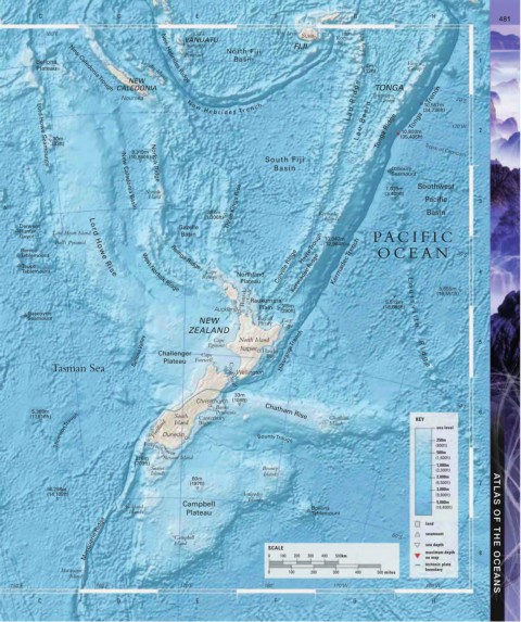
C D E F G H 481
160˚E 170˚E Viti Levu Suva 180˚
VANUATU Koro
Erromango FIJI Sea Lau Group
North Fiji
Pentecost
Bellona Basin Vava’u 1
Plateau New Caledonia Trough CALEDONIA 4m Group
(13ft)
NEW TONGA
Loyalty Islands
L a u R i d g e Group 20˚S
New Hebrides Ridge
Nouméa Tongatapu
N e w H e b r i d e s Tr e n ch Tonga Trench
10,567m
(34,736ft)
10,800m
10m L a u B a s i n Tonga Ridge (35,435ft) 170˚W 2
(33ft)
3,319m Tropic of Capricorn
(10,890ft)
South Fiji
Basin Ozbourn
Lord Howe Seamounts
Seamount
Norfolk Ridge
1,039m
Norfolk (3,409ft) Southwest
Island Pacific 3
New Caledonia Basin
398m Three Kings Rise Kermadec Basin
(1,306ft) Islands
Derwent Gazelle
Hunter Lord Howe Island
Guyot Basin 10,047m PA CIFIC
Ball’s Pyramid Lord Howe Rise (32,964ft)
Barcoo Havre Trough
Tablemount Reinga Ridge OCEAN 30˚S
Taupo Colville Ridge Kermadec Trench
Tablemount West Norfolk Ridge Cape Kermadec Ridge 4
Reinga Northland
Plateau L 5,655m
Hauraki Gulf Raukumara 5,512m u (18,551ft)
o
i
s
119m
Auckland Plain (390ft) (18,085ft) v
Gascoyne i
Seamount Bay of l
NEW Plenty East l
Cape
e
ZEALAND North Island
Bellona Valley Challenger Cape Napier Hawke Hikurangi Trench R d 5
Cape
Egmont
i
Bay
g
Tasman Sea Plateau Farewell e
Wellington
Cook Strait
33m
Christchurch (108ft)
Banks 40˚S
5,369m Peninsula Chatham Rise 6
Thomson Trough Fiordland Dunedin Bounty Trough Islands sea level
South
(17,616ft) Island Canterbury Chatham KEY
Bight
250m
(800ft)
500m
Foveaux Strait
216m Stewart Island (1,600ft)
(709ft) 1,000m
Snares Bounty (3,300ft)
Islands Islands
60m 2,000m
(197ft) (6,500ft) 7
4,298m 3,000m
(14,102ft) Antipodes (9,800ft)
Islands
Campbell 5,000m
Auckland Bollons (16,400ft)
Islands Plateau Tablemount land
Macquarie Ridge Campbell SCALE 50˚S seamount ATLAS OF THE OCEANS
Island
sea depth
maximum depth
0
100
400
500km
300
200
on map
tectonic plate 8
Macquarie 0 100 200 300 400 500 miles boundary
Island
150˚E 160˚E 170˚E 180˚ 170˚W 160˚W
C D E F G H