
Page 72 - (DK) Ocean - The Definitive Visual Guide
P. 72
70 CIRCULATION AND CLIMATE
Hurricanes and Typhoons
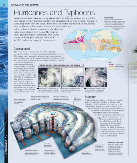
HURRICANES AND TYPHOONS ARE TERMS USED IN different parts of the world for DISTRIBUTION
Severe tropical cyclones start as
very similar weather phenomena. They are characterized by violent winds moving in depressions over warm oceans in the
a circular pattern over the ocean, dense bands of clouds, and rainfall. In the Atlantic tropics. They move across the ocean
surface for several days, causing
they are known as hurricanes; those in the west Pacific are huge damage on reaching land. Their
paths are shown in the
called typhoons. Similar phenomena elsewhere are map above.
A R C T I C O C E A N
called severe storms or cyclones. They start as
a low-pressure system (depression) over warm
oceans in the tropics, between latitudes 5°
and 20°, and occur mainly in late summer. P A CIFIC
OCEAN
P A CIFIC A T L A N T I C O C E A N INDIAN
OCEAN OCEAN
Development
All tropical cyclones develop from the effects of the Sun
warming the surface of a broad area of ocean and the air above it.
This heating causes masses of warm, moist air to rise, creating a
S O U T H E R N O C E A N
region of low pressure at the surface, and dense clouds above it. The
low pressure sucks in more air, which spirals to the center, creating
a circular wind system. As it KEY
grows stronger, becoming THREE DEVELOPMENT STAGES: HURRICANE SANDY, OCTOBER 2012 hurricanes
a tropical storm, it is pushed severe cyclones
westward by the prevailing typhoons
trade winds. In the Atlantic, a
storm attains hurricane status
once its winds exceed 74 mph
(119 kph). Eventually, most of
these violent storms move
away from the equator—
that is, to the north in the
Northern Hemisphere. When
one reaches land, it begins to
1 On October 23 a swirling mass of 2 By October 26, the cyclone has 3 At full hurricane status on October
lose energy, as it is no longer warm, moist air rises over a tropical a spiral form, with a dense central 28, the cyclone has compacted and
fed by heat from the ocean. area of ocean, condensing into clouds. nucleus of clouds. developed a clear central “eye.”
eyewall is a ring of destructive eye of the hurricane is a Structure
thunderstorms and rainbands calm, cloud-free area of high-level
cap of cirrus clouds around the eye sinking air and light winds winds spiral A fully developed typhoon or hurricane is usually
over cumulonimbus outward
that forms bulk 185–370 miles (300–600 km) in diameter and
of clouds
6–9 miles (10–15 km) high. At its center is a calm
region of low atmospheric pressure, called the eye.
Within the rest of the cyclone, winds spiral in an
counterclockwise direction in the Northern
Hemisphere and clockwise in the
Southern Hemisphere (the difference is
due to the Coriolis effect, see p. 54).
Within an area surrounding the
eye, called the eyewall, the air
spins upward, forming dense
clouds. The eye stays calm
because the winds that spiral in
toward it never reach the center.
Radiating out from the eye and
eyewall are well-defined bands of
INTRODUCTION low pressure at water’s sea surface cool, dry air spiral rainbands HURRICANE STRUCTURE
clouds, called rainbands.
A hurricane consists of the
rises at center
central eye, which can be
can extend for
of hurricane
5–120 miles (8–200 km)
hundreds of
miles from the
across, the eyewall (a
ascending warm,
hurricane center
column of thick clouds,
surface creates warm
moist air created
rain, and upward-spiraling
sinking toward
winds; these increase in
by solar heating of
winds), and the rainbands.
the ocean surface
speed toward the eye
the ocean surface