
Page 75 - (DK) Ocean - The Definitive Visual Guide
P. 75
73
Typhoon Haiyan
Typhoon Haiyan, known in the Philippines as Typhoon
PATH OF DESTRUCTION
Yolanda, was an exceedingly powerful tropical cyclone
that devastated the Philippines and some other EYE OF THE STORM
Haiyan originated around
parts of Southeast Asia between November 4 and
November 2 from an area of
November 11, 2013. It is the deadliest typhoon ever low pressure in the western
recorded in the Philippines, killing more than 6,000 Pacific. Over the next
3–4 days, it grew into a
people in that country alone. Haiyan is also the most GENESIS super-typhoon and developed
powerful storm ever to hit land, and the fourth most a distinct “eye” at its center.
intense tropical cyclone ever recorded in terms of
highest sustained wind speeds. STORM SURGE By November 7,
Haiyan was producing sustained
Most of the catastrophic destruction occurred in a
winds of up to 168 mph (270 kph).
central group of islands within the Philippines called The next day, it made landfall in
the Visayas. Although wind speeds were extreme, the the Philippines, where a storm
surge pounded coastal areas.
major cause of damage and loss of life was a storm
surge, particularly hitting the eastern coasts of the
islands of Samar and Leyte. The city of Tacloban,
with a population of over 220,000, was almost
completely destroyed. On November 10 and 11, EVACUATION Warnings had
been issued across a wide
Haiyan passed over Vietnam and southern China, LANDFALL IN PHILIPPINES region to evacuate or seek
by which time it had weakened to a tropical storm safe refuge. Here, a Filipino
child is being taken to board
and then to a depression. Nevertheless, there was a military plane as part of
extensive flooding in some areas, thousands of homes an evacuation program.
were destroyed, and around 50 people were killed.
Some climate scientists believe that global warming
will increase the frequency of high-intensity tropical
cyclones like Typhoon Haiyan. If this is the case,
governments in affected countries will need to make
provisions for dealing with similar-scale catastrophes
more often in the future.
DESTROYED COMMUNITY The destruction caused to parts of the
central Philippines that Haiyan passed across was almost total. This
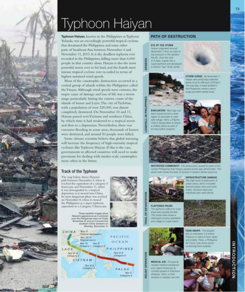
Track of the Typhoon aerial view shows the town of Guiuan in eastern Samar province.
The map below shows Haiyan’s INFRASTRUCTURE DAMAGE
path between November 5, when it The high level of destruction in
reached the equivalent of a category 4 urban areas, which included
hurricane, and November 11, when downed power lines and radio
it was downgraded to a tropical masts, blocked roads and
depression as it moved into China. interfered with relief efforts.
Its most dangerous phase was reached
on November 8, when it crossed
the Philippines as a super-typhoon,
equivalent to a Category 5 hurricane. TRAIL OF DEVASTATION FLATTENED PALMS
The typhoon’s effect on rural
These satellite images show areas was equally terrible.
Haiyan’s appearance as it centered This aerial view shows a
over the Philippines (top) on Friday destroyed coconut plantation
November 8, and as it moved into and village on Leyte island.
southern China (bottom) on
Monday, November 11.
CHINA Nov 11 FOOD DROPS The disaster
Tropical depression left an estimated 1.9 million
Nov 10–11 P A CIFIC Filipinos in need of food, water,
Tropical storm and shelter. Here, a Philippine
OCEAN
Nov 10 Nov 9 Air Force crew drops sacks
Category 1 Category 3 containing food supplies.
LA OS P H ILPPINES
Nov 9–10 Nov 6–8
Category 2 Category 5
VIETNAM MEDICAL AID Thousands INTRODUCTION
Nov 8–9 RELIEF OPERATION needed medical assistance
Category 4 and urgent measures to
P ALA U combat spread of infectious
Nov 5
Category 4 diseases. Here, a child
receives a measles vaccine.