
Page 49 - Towards_a_New_Malaysia_The_2018_Election_and_Its_6146371_(z-lib.org)
P. 49
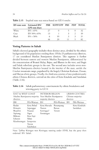
34                                        Ibrahim Su an and Lee Tai De

                  Table 2.15  Implied state seat status based on GE14 results

                   BN state seats Estimated BN/  PBB  SUPP/UPP PRS   PDP TOTAL
                               GPS vote share
                   White       BN > 65%          27       0       5     0    32
                   Grey        BN 50%–65%        13       1       3     2    19
                   Black       BN < 50%           6     19        3     3    31
                                                 46     20       11     5    82


                  Voting Patterns in Sabah
                  Sabah’s electoral geography includes three distinct areas, divided by the ethnic
                  background of the population residing there. Of the 25 parliamentary districts,
                  17 are considered Muslim Bumiputera districts.  is segment is further
                  divided between eastern and western Muslim Bumiputera, di erentiated by
                  the concentration of Brunei Malay, Bajau, and Illanun in the west, and Bugis
                  and Suluk subethnic groups in the east.  e second area includes seven non-
                  Muslim Bumiputera districts located in the interior of the state, astride the
                  Crocker mountain range, populated by the largely Christian Kadazan, Dusun,
                  and Murut ethnic groups. Finally, the third area consists of two predominantly
                  ethnic-Chinese districts, centred on the cities of Kota Kinabalu and Sandakan
                  (Table 2.16).

                  Table 2.16  Sabah parliamentary constituencies by ethnic breakdown and
                              winning party in GE14

                   EAST & WEST COAST      INTERIOR REGION        URBAN CENTRES
                   Muslim Bumiputera-majority  Non-Muslim Bumiputera-  Chinese-majority-
                   districts              majority districts     districts
                   BN          PH+Warisan BN          PH+Warisan BN   PH+Warisan
                   Kudat       Kota Belud  Kota Marudu Penampang      Kota Kinabalu
                   Kimanis     Sepanggar  Tuaran      Ranau           Sandakan
                   Beaufort    Putatan    Keningau*   Tenom
                   Sipitang    Papar      Pensiangan
                   Beluran     Batu Sapi
                   Libaran     Silam
                   Kinabatangan Semporna
                               Tawau
                               Kalabakan
                  Note: *Je rey Kitingan won Keningau running under STAR, but the party then
                  endorsed BN Sabah.


                        This content downloaded from 139.80.253.0 on Fri, 06 Nov 2020 04:21:47 UTC
                                   All use subject to https://about.jstor.org/terms