
Page 194 - NAVAL SCIENCE 3 TEXTBOOK
P. 194
200 NAVAL SK ILLS
Dead Reckoning
\·Vhen a ship is out of sight of lilnd, or electronic navigation is not
available and bad weather prevents taking celestial obscrvations,
thc ship must be navigated b}' dead reckoning. Dead reckoning
means determining a position from the direction and distance the-
oreticall)· traveled from a known stilrting point. normall), the last
good fix.
In dead reckoning, a line called a collrse Ihle is drawn on a nau-
tical chart from evcry new fix in the direction in which the ship
is proceeding. The dircction, or course, is labeled above the line,
and speed in knots below the line. Then, future positions called
Dii (dead reckoning) positiolls are computed, plotted, and labeled
along this line as required for snfc navigation. This is the dead
reckon;llg (DR) track for the ship. tillt a ship under wa), is mov-
ing through water, a vcr)' unstable element. \·Vind and current may
cause the ship to drift from the presumed course, or its speed to
vary from what is set, even though the helmsman has very care-
fully tried to steer the exact course. For this reason, dead reckon-
ing positions are only approximilte, and their accuraC)' decreases
over time.
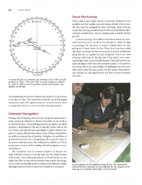
A sample DR plot on a compass rose, showing a fix at 1200, and DR
positions at 1300, 1330, and 1400. A course change was ordered
at 1330. At 1400 a new fix was taken and the ship's position was
updated accordingly.
rate positioning information without such updates for up to seven
to ten da)'s or more. This makes them ideal for usc in submerged
submarines when GPS signals cannot be received, such as when
cruising under Arctic ice, or on extended submerged patrols.
Celestial Navigation
Piloting, dead reckoning, and electronic navigation systems deter-
mine position by reference to objects or localities on the Earth or
in near-Earth space. The remaining branch of navigation, in which
position is determined by the aid of heavenly bodies stich as the
Sun, 1\,loon, and selected stars and planets, is called ce/estia/1J(lI'i-
gatioll. A precise altitude observation of any of these celestial bod-
ies yields an accurate line of position. Navigation by such lines of
position has been the key to navigating on the oceans for much of
the past two hundred ),ears. The widespread availability of GPS in
recent years. however, is fast making celestial navigation at sea a
vanishing art.
The instrument lIsed in celestial navigiltion to meilsure the
angle (altitude) between a heavenl), bod)' and the visible horizon
is the SWnlll. After fi nding the altitude of several bodies, or of a
single body like the Sun over rill extended time period, the naviga-
tor can work out the ship's position using various almanacs. tables,
A quartermaster on the amphibious assault ship USS Bonhomme
and sight reduction forms or electronic calculator or computer. Richard (LHD 6) maintains the ship's DR plot for the navigator while
entering port at Seattie, Washington. (John Ciccarelli)