
Page 485 - 9780077418427.pdf
P. 485
/Users/user-f465/Desktop
tiL12214_ch18_455-476.indd Page 462 9/3/10 6:21 PM user-f465
tiL12214_ch18_455-476.indd Page 462 9/3/10 6:21 PM user-f465 /Users/user-f465/Desktop
150 120 90 60 30 0 30 60 90
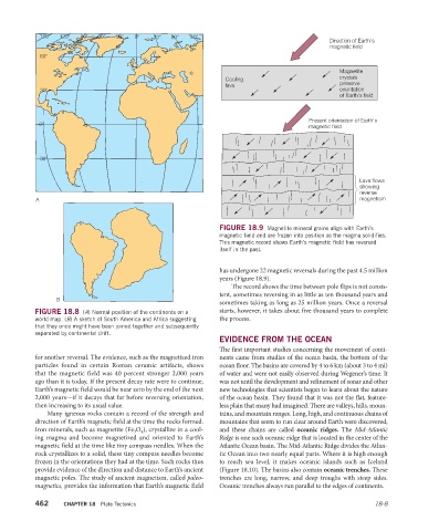
Direction of Earth's
magnetic field
60
Magnetite
Cooling crystals
lava preserve
30 orientation
of Earth's field
Present orientation of Earth's
0 magnetic field
30
Lava flows
showing
reverse
A magnetism
FIGURE 18.9 Magnetite mineral grains align with Earth’s
magnetic field and are frozen into position as the magma solidifies.
This magnetic record shows Earth’s magnetic field has reversed
itself in the past.
has undergone 22 magnetic reversals during the past 4.5 million
years (Figure 18.9).
The record shows the time between pole flips is not consis-
tent, sometimes reversing in as little as ten thousand years and
B
sometimes taking as long as 25 million years. Once a reversal
FIGURE 18.8 (A) Normal position of the continents on a starts, however, it takes about five thousand years to complete
world map. (B) A sketch of South America and Africa suggesting the process.
that they once might have been joined together and subsequently
separated by continental drift.
EVIDENCE FROM THE OCEAN
The first important studies concerning the movement of conti-
for another reversal. The evidence, such as the magnetized iron nents came from studies of the ocean basin, the bottom of the
particles found in certain Roman ceramic artifacts, shows ocean floor. The basins are covered by 4 to 6 km (about 3 to 4 mi)
that the magnetic field was 40 percent stronger 2,000 years of water and were not easily observed during Wegener’s time. It
ago than it is today. If the present decay rate were to continue, was not until the development and refinement of sonar and other
Earth’s magnetic field would be near zero by the end of the next new technologies that scientists began to learn about the nature
2,000 years—if it decays that far before reversing orientation, of the ocean basin. They found that it was not the flat, feature-
then increasing to its usual value. less plain that many had imagined. There are valleys, hills, moun-
Many igneous rocks contain a record of the strength and tains, and mountain ranges. Long, high, and continuous chains of
direction of Earth’s magnetic field at the time the rocks formed. mountains that seem to run clear around Earth were discovered,
Iron minerals, such as magnetite (Fe 3 O 4 ), crystallize in a cool- and these chains are called oceanic ridges. The Mid-Atlantic
ing magma and become magnetized and oriented to Earth’s Ridge is one such oceanic ridge that is located in the center of the
magnetic field at the time like tiny compass needles. When the Atlantic Ocean basin. The Mid- Atlantic Ridge divides the Atlan-
rock crystallizes to a solid, these tiny compass needles become tic Ocean into two nearly equal parts. Where it is high enough
frozen in the orientations they had at the time. Such rocks thus to reach sea level, it makes oceanic islands such as Iceland
provide evidence of the direction and distance to Earth’s ancient ( Figure 18.10). The basins also contain oceanic trenches. These
magnetic poles. The study of ancient mag netism, called paleo- trenches are long, narrow, and deep troughs with steep sides.
magnetics, provides the information that Earth’s magnetic field Oceanic trenches always run parallel to the edges of continents.
462 CHAPTER 18 Plate Tectonics 18-8