
Page 592 - 9780077418427.pdf
P. 592
/Volume/201/MHDQ233/tat78194_disk1of1/0073378194/tat78194_pagefiles
tiL12214_ch23_565-596.indd Page 569 9/23/10 11:07 AM user-f465
tiL12214_ch23_565-596.indd Page 569 9/23/10 11:07 AM user-f465 /Volume/201/MHDQ233/tat78194_disk1of1/0073378194/tat78194_pagefile
droplets making up the cloud and the relative positions of you, the
cloud, and the Sun. You will see a white cloud, for example, if you
are between the cloud and the Sun so that you see reflected sun-
light from the cloud. The same cloud will appear to be gray if it is
between you and the Sun, positioned so that it filters the sunlight
coming toward you. (For an additional worked example on this
material, see the chapter 23 resources at www.mhhe.com/tillery.)
ORIGIN OF PRECIPITATION
Water that returns to the surface of Earth, in either the liquid or
solid form, is called precipitation (Figure 23.5). Note that dew
and frost are not classified as precipitation because they form
directly on the surface and do not fall through the air. Precipita-
tion seems to form in clouds by one of two processes: (1) the
coalescence of cloud droplets or (2) the growth of ice crystals.
It would appear difficult for cloud droplets to merge, or coalesce,
with one another since any air movement moves them all at the
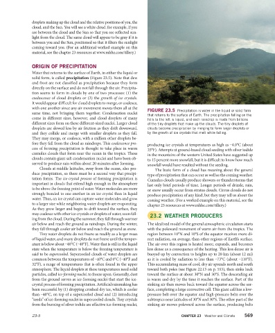
FIGURE 23.5 Precipitation is water in the liquid or solid form
same time, not bringing them together. Condensation nuclei
that returns to the surface of Earth. The precipitation falling on the
come in different sizes, however, and cloud droplets of many hills to the left is liquid, and each raindrop is made from billions
different sizes form on these different-sized nuclei. Larger cloud of the tiny droplets that make up the clouds. The tiny droplets of
droplets are slowed less by air friction as they drift downward, clouds become precipitation by merging to form larger droplets or
and they collide and merge with smaller droplets as they fall. by the growth of ice crystals that melt while falling.
They may merge, or coalesce, with a million other droplets be-
fore they fall from the cloud as raindrops. This coalescence pro-
producing ice crystals at temperatures as high as –4.0°C (about
cess of forming precipitation is thought to take place in warm
25°F). Attempts at ground-based cloud seeding with silver iodide
cumulus clouds that form near the ocean in the tropics. These
in the mountains of the western United States have suggested up
clouds contain giant salt condensation nuclei and have been ob-
to 15 percent more snowfall, but it is difficult to know how much
served to produce rain within about 20 minutes after forming.
snowfall would have resulted without the seeding.
Clouds at middle latitudes, away from the ocean, also pro-
The basic form of a cloud has meaning about the general
duce precipitation, so there must be a second way that precipi-
type of precipitation that can occur as well as the coming weather.
tation forms. The ice-crystal process of forming precipitation is
Cumulus clouds usually produce showers or thunderstorms that
important in clouds that extend high enough in the atmosphere
last only brief periods of time. Longer periods of drizzle, rain,
to be above the freezing point of water. Water molecules are more
or snow usually occur from stratus clouds. Cirrus clouds do not
strongly bonded to one another in an ice crystal than in liquid
produce precipitation of any kind, but they may tell us about the
water. Thus, an ice crystal can capture water molecules and grow
coming weather. (For a worked example on this material, see the
to a larger size while neighboring water droplets are evaporating.
chapter 23 resources at www.mhhe.com/tillery.)
As they grow larger and begin to drift toward the surface, they
may coalesce with other ice crystals or droplets of water, soon fall- 23.2 WEATHER PRODUCERS
ing from the cloud. During the summer, they fall through warmer
air below and reach the ground as raindrops. During the winter, The idealized model of the general atmospheric circulation starts
they fall through cooler air below and reach the ground as snow. with the poleward movement of warm air from the tropics. The
Tiny water droplets do not freeze as readily as a larger mass region between 10°N and 10°S of the equator receives more di-
of liquid water, and many droplets do not freeze until the temper- rect radiation, on average, than other regions of Earth’s surface.
ature is below about –40°C (–40°F). Water that is still in the liquid The air over this region is heated more, expands, and becomes
state when the temperature is below the freezing temperature is less dense as a consequence of the heating. This less dense air is
said to be supercooled. Supercooled clouds of water droplets are buoyed up by convection to heights up to 20 km (about 12 mi)
common between the temperatures of –40°C and 0°C (–40°F and as it is cooled by radiation to less than –73°C (about –110°F).
32°F), a range of temperatures that is often found in the upper This accumulating mass of cool, dry air spreads north and south
atmosphere. The liquid droplets at these temperatures need solid toward both poles (see Figure 22.13 on p. 553), then sinks back
particles, called ice-forming nuclei, to freeze upon. Generally, dust toward the surface at about 30°N and 30°S. The descending air
from the ground serves as ice-forming nuclei that start the ice- is warm and dry by the time it reaches the surface. Part of the
crystal process of forming precipitation. Artificial rainmaking has sinking air then moves back toward the equator across the sur-
been successful by (1) dropping crushed dry ice, which is cooler face, completing a large convective cell. This giant cell has a low-
than –40°C, on top of a supercooled cloud and (2) introducing pressure belt over the equator and high-pressure belts over the
“seeds” of ice-forming nuclei in supercooled clouds. Tiny crystals subtropics near latitudes of 30°N and 30°S. The other part of the
from the burning of silver iodide are effective ice-forming nuclei, sinking air moves poleward across the surface, producing belts
23-5 CHAPTER 23 Weather and Climate 569