
Page 593 - 9780077418427.pdf
P. 593
/Volume/201/MHDQ233/tat78194_disk1of1/0073378194/tat78194_pagefile
tiL12214_ch23_565-596.indd Page 570 9/23/10 11:07 AM user-f465
tiL12214_ch23_565-596.indd Page 570 9/23/10 11:07 AM user-f465 /Volume/201/MHDQ233/tat78194_disk1of1/0073378194/tat78194_pagefiles
Siberia for some time will become cold and dry. A
large body of air that remains over a warm tropical
ocean, on the other hand, will become warm and
moist. Knowledge about the condition of air masses
is important because they tend to retain the acquired
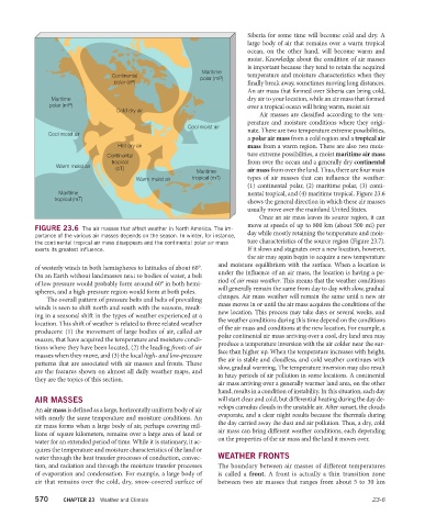
Maritime
Continental polar (mP) temperature and moisture characteristics when they
polar (cP) finally break away, sometimes moving long distances.
An air mass that formed over Siberia can bring cold,
Maritime dry air to your location, while an air mass that formed
polar (mP) over a tropical ocean will bring warm, moist air.
Cold dry air
Air masses are classified according to the tem-
perature and moisture conditions where they origi-
Cool moist air
Cool moist air nate. There are two temperature extreme possibilities,
a polar air mass from a cold region and a tropical air
Hot dry air mass from a warm region. There are also two mois-
Continental ture extreme possibilities, a moist maritime air mass
tropical from over the ocean and a generally dry continental
Warm moist air (cT)
Maritime air mass from over the land. Thus, there are four main
Warm moist air tropical (mT) types of air masses that can influence the weather:
(1) continental polar, (2) maritime polar, (3) conti-
Maritime nental tropical, and (4) maritime tropical. Figure 23.6
tropical (mT)
shows the general direction in which these air masses
usually move over the mainland United States.
Once an air mass leaves its source region, it can
move at speeds of up to 800 km (about 500 mi) per
FIGURE 23.6 The air masses that affect weather in North America. The im-
portance of the various air masses depends on the season. In winter, for instance, day while mostly retaining the temperature and mois-
the continental tropical air mass disappears and the continental polar air mass ture characteristics of the source region (Figure 23.7).
exerts its greatest influence. If it slows and stagnates over a new location, however,
the air may again begin to acquire a new temperature
and moisture equilibrium with the surface. When a location is
of westerly winds in both hemispheres to latitudes of about 60°.
under the influence of an air mass, the location is having a pe-
On an Earth without landmasses next to bodies of water, a belt
riod of air mass weather. This means that the weather conditions
of low pressure would probably form around 60° in both hemi-
will generally remain the same from day to day with slow, gradual
spheres, and a high-pressure region would form at both poles.
changes. Air mass weather will remain the same until a new air
The overall pattern of pressure belts and belts of prevailing
mass moves in or until the air mass acquires the conditions of the
winds is seen to shift north and south with the seasons, result-
new location. This process may take days or several weeks, and
ing in a seasonal shift in the types of weather experienced at a
the weather conditions during this time depend on the conditions
location. This shift of weather is related to three related weather of the air mass and conditions at the new location. For example, a
producers: (1) the movement of large bodies of air, called air
polar continental air mass arriving over a cool, dry land area may
masses, that have acquired the temperature and moisture condi-
produce a temperature inversion with the air colder near the sur-
tions where they have been located, (2) the leading fronts of air
face than higher up. When the temperature increases with height,
masses when they move, and (3) the local high- and low-pressure
the air is stable and cloudless, and cold weather continues with
patterns that are associated with air masses and fronts. These
slow, gradual warming. The temperature inversion may also result
are the features shown on almost all daily weather maps, and
in hazy periods of air pollution in some locations. A continental
they are the topics of this section.
air mass arriving over a generally warmer land area, on the other
hand, results in a condition of instability. In this situation, each day
AIR MASSES will start clear and cold, but differential heating during the day de-
velops cumulus clouds in the unstable air. After sunset, the clouds
An air mass is defined as a large, horizontally uniform body of air
evaporate, and a clear night results because the thermals during
with nearly the same temperature and moisture conditions. An
the day carried away the dust and air pollution. Thus, a dry, cold
air mass forms when a large body of air, perhaps covering mil-
air mass can bring different weather conditions, each depending
lions of square kilometers, remains over a large area of land or
on the properties of the air mass and the land it moves over.
water for an extended period of time. While it is stationary, it ac-
quires the temperature and moisture characteristics of the land or
water through the heat transfer processes of conduction, convec- WEATHER FRONTS
tion, and radiation and through the moisture transfer processes The boundary between air masses of different temperatures
of evaporation and condensation. For example, a large body of is called a front. A front is actually a thin transition zone
air that remains over the cold, dry, snow-covered surface of between two air masses that ranges from about 5 to 30 km
570 CHAPTER 23 Weather and Climate 23-6