
Page 596 - 9780077418427.pdf
P. 596
/Volume/201/MHDQ233/tat78194_disk1of1/0073378194/tat78194_pagefile
tiL12214_ch23_565-596.indd Page 573 9/23/10 11:07 AM user-f465
tiL12214_ch23_565-596.indd Page 573 9/23/10 11:07 AM user-f465 /Volume/201/MHDQ233/tat78194_disk1of1/0073378194/tat78194_pagefiles
Science and Society
Urban Heat Islands
rban areas are often 2 to 10 degrees It is possible to reduce the heat is- break to encourage developers to
Uwarmer at night than the surround- land effect by using alternatives to con- diminish the heat island effect? Why
ing rural areas. Climatologists call this ventional asphalt and concrete. Resins or why not?
difference the urban heat island effect. This and rubberized asphalt, for example, do 2. What are the advantages and dis -
effect is created by all the bricks, concrete, not absorb as much heat during the day. advantages of required urban plan-
and asphalt of buildings, parking lots, and Landscaping to create islands of “urban ning, including the creation of forest
streets. These structures are warmed by sun- forests” also helps. islands in urban areas?
light during the day, then reradiate stored
3. What solutions can you think of to
heat at night. Building surfaces also disrupt
QUESTIONS TO DISCUSS diminish the urban heat island
the normal cooling by infrared radiation.
effect?
Surrounding rural areas are cooler because 1. Developers are slow to consider taking
less heat is absorbed during the day, and steps to diminish heat island effects.
more is released by radiation at night. Should governments provide a tax
wind direction and a rapid increase in the barometric pressure. clouds. This light rain (and snow in the winter) may last for days
Before the cold front arrives, the wind is generally moving toward as the warm front passes.
the front as warm, less dense air is forced upward by the cold, Sometimes the forces influencing the movement of a cold
denser air. The lowest barometric pressure reading is associated or warm air mass lessen or become balanced, and the front stops
with the lifting of the warm air at the front. After the front passes advancing. When this happens, a stream of cold air moves along
your location, you are in the cooler, denser air that is settling out- the north side of the front, and a stream of warm air moves
ward, so the barometric pressure increases and the wind shifts along the south side in an opposite direction. This is called a
with the movement of the cold air mass. stationary front because the edge of the front is not advancing
A warm front forms when a warm air mass advances over (Figure 23.12A). A stationary front may sound as if it is a mild
a mass of cooler air. Since the advancing warm air is less dense
than the cooler air it is displacing, it generally overrides the
cooler air, forming a long, gently sloping front. Because of this, Cold air Warm front
the overriding warm air may form clouds far in advance of the
ground-level base of the front (Figure 23.11). This may produce
high cirrus clouds a day or more in advance of the front, which Warm air Cold
front
are followed by thicker and lower stratus clouds as the front ad- A B
vances. Usually these clouds result in a broad band of drizzle,
fog, and the continuous light rain usually associated with stratus Occluded
front
Low pressure
10
C D
Cirrus
Altitude (km) 5 Warm air mass Air flow L
Cold E
air
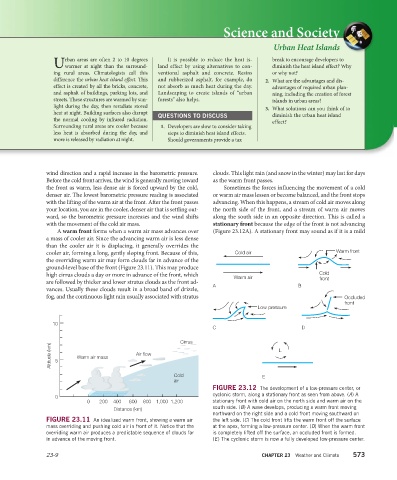
FIGURE 23.12 The development of a low-pressure center, or
0 cyclonic storm, along a stationary front as seen from above. (A) A
0 200 400 600 800 1,000 1,200 stationary front with cold air on the north side and warm air on the
Distance (km) south side. (B) A wave develops, producing a warm front moving
northward on the right side and a cold front moving southward on
FIGURE 23.11 An idealized warm front, showing a warm air the left side. (C) The cold front lifts the warm front off the surface
mass overriding and pushing cold air in front of it. Notice that the at the apex, forming a low-pressure center. (D) When the warm front
overriding warm air produces a predictable sequence of clouds far is completely lifted off the surface, an occluded front is formed.
in advance of the moving front. (E) The cyclonic storm is now a fully developed low-pressure center.
23-9 CHAPTER 23 Weather and Climate 573