
Page 594 - 9780077418427.pdf
P. 594
/Volume/201/MHDQ233/tat78194_disk1of1/0073378194/tat78194_pagefile
tiL12214_ch23_565-596.indd Page 571 9/23/10 11:07 AM user-f465
tiL12214_ch23_565-596.indd Page 571 9/23/10 11:07 AM user-f465 /Volume/201/MHDQ233/tat78194_disk1of1/0073378194/tat78194_pagefiles
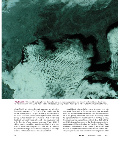
FIGURE 23.7 This satellite photograph shows the result of a polar air mass moving southeast over the southern United States. Clouds form
over the warmer waters of the Gulf of Mexico and the Atlantic Ocean, showing the state of atmospheric instability from the temperature differences.
(about 3 to 20 mi) wide, and the air masses do not mix other A cold front is formed when a cold air mass moves into
than in this narrow zone. The density differences between the warmer air, displacing it in the process. A cold front is generally
two air masses prevent any general mixing since the warm, steep, and when it runs into the warmer air, it forces the warmer
less dense air mass is forced upward by the cooler, denser air air to rise quickly. If the warm air is moist, it is quickly cooled
moving under it. You may have noticed on a daily weather map by expansion to the dew point temperature, resulting in large,
that fronts are usually represented with a line bulging outward towering cumulus clouds and thunderclouds along the front (Fig-
in the direction of cold air mass movement (Figure 23.8). A ure 23.10). You may have observed that thunderstorms created by
cold air mass is much like a huge, flattened bubble of air that an advancing cold front often form in a line along the front. These
moves across the land (Figure 23.9). The line on a weather thunderstorms can be intense but are usually over quickly, soon
map represents the place where the leading edge of this huge, followed by a rapid drop in temperature from the cold air mass.
flattened bubble of air touches the surface of Earth. The passage of the cold front is also marked by a rapid shift in the
23-7 CHAPTER 23 Weather and Climate 571