
Page 605 - 9780077418427.pdf
P. 605
/Volume/201/MHDQ233/tat78194_disk1of1/0073378194/tat78194_pagefile
tiL12214_ch23_565-596.indd Page 582 9/23/10 11:07 AM user-f465
tiL12214_ch23_565-596.indd Page 582 9/23/10 11:07 AM user-f465 /Volume/201/MHDQ233/tat78194_disk1of1/0073378194/tat78194_pagefiles
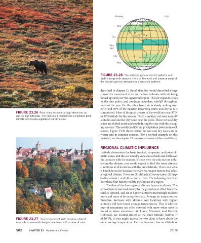
January July
Wet
Dry
Very
wet
Dry
Wet
FIGURE 23.28 The idealized general rainfall patterns over
Earth change with seasonal shifts in the wind and pressure areas of
the planet’s general atmospheric circulation patterns.
described in chapter 22. Recall that this model described a huge
convective movement of air in the low latitudes, with air being
forced upward over the equatorial region. This air expands, cools
to the dew point, and produces abundant rainfall throughout
most of the year. On the other hand, air is slowly sinking over
30°N and 30°S of the equator, becoming warm and dry as it is
FIGURE 23.26 Polar climates occur at high elevations as compressed. Most of the great deserts of the world are near 30°N
well as high latitudes. This mountain location has a highland polar or 30°S latitude for this reason. There is another wet zone near 60°
climate and tundra vegetation but little else. latitudes and another dry zone near the poles. These wet and dry
zones are shifted north and south during the year with the chang-
ing seasons. This results in different precipitation patterns in each
season. Figure 23.28 shows where the wet and dry zones are in
winter and in summer seasons. (For a worked example on this
material, see the chapter 23 resources at www.mhhe.com/tillery.)
REGIONAL CLIMATIC INFLUENCE
Latitude determines the basic tropical, temperate, and polar cli-
matic zones, and the wet and dry zones move back and forth over
the latitudes with the seasons. If these were the only factors influ-
encing the climate, you would expect to find the same climatic
conditions at all locations with the same latitude. This is not what
is found, however, because there are four major factors that affect
a regional climate. These are (1) altitude, (2) mountains, (3) large
bodies of water, and (4) ocean currents. The following describes
how these four factors modify the climate of a region.
The first of the four regional climate factors is altitude. The
atmosphere is warmed mostly by the greenhouse effect from the
surface upward, and air at higher altitudes increasingly radiates
more and more of its energy to space. Average air temperatures,
therefore, decrease with altitude, and locations with higher
altitudes will have lower average temperatures. This is why the
tops of mountains are often covered with snow when none is
found at lower elevations. St. Louis, Missouri, and Denver,
Colorado, are located almost at the same latitude (within 1°
FIGURE 23.27 This temperate-climate deciduous forest of 39°N), so you might expect the two cities to have about the
responds to seasonal changes in autumn with a show of color. same average temperature. Denver, however, has an altitude of
582 CHAPTER 23 Weather and Climate 23-18